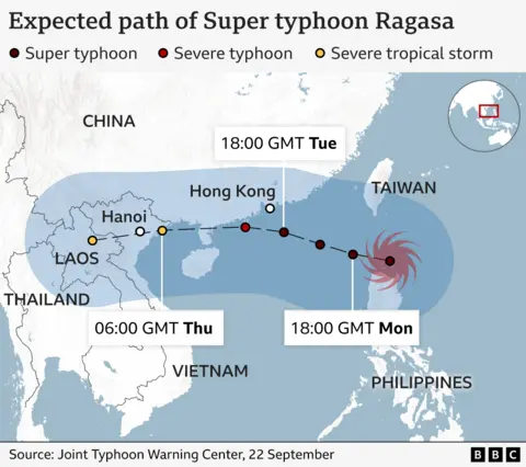
Super Typhoon Ragasa, locally called “Nando,” is a Category 5 storm with winds of 205 km/h and gusts up to 250 km/h. Originating in the warm western Pacific, it moves across the Luzon Strait toward the Babuyan Islands and southern China.
Copyright infringement not intended
Picture Courtesy: ECONOMICTIMES
The Philippines issued high alerts, halting work and classes, as Super Typhoon Ragasa, which originated over western Pacific Ocean, made its approach toward the northern island of Luzon.
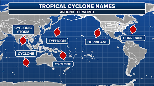
Tropical cyclones are intense, rotating storm systems with a low-pressure center, strong winds, and a spiral arrangement of thunderstorms that produce heavy rain. They are known by different names in different parts of the world:
A Super Typhoon is an extremely intense typhoon, equivalent to a Category 5 hurricane on the Saffir-Simpson scale, with sustained winds exceeding 240 km/h.
The World Meteorological Organization (WMO) maintains rotating lists of names for cyclones. National meteorological agencies in affected regions often assign their own local names. For example, the Philippine agency PAGASA gives local names (like "Nando" for Ragasa) to typhoons entering its area of responsibility to make warnings more relatable to local citizens.
The formation of a powerful typhoon like Ragasa requires a specific set of conditions:
Source: ECONOMICTIMES
|
PRACTICE QUESTION Q. Which country was the first to be severely impacted by Super Typhoon Ragasa? A) Thailand B) Japan C) Myanmar D) Philippines Answer: D Explanation: Super Typhoon Ragasa (locally known as Nando) first made landfall in the Philippines. |
The Western Pacific has consistently high sea surface temperatures (>26.5 C) and low vertical wind shear, ideal for cyclone formation.
A "Super Typhoon" is a classification in the Western Pacific for a typhoon with sustained winds of at least 240 km/h, indicating extreme intensity.
The Coriolis effect, caused by Earth's rotation, deflects the winds flowing into a low-pressure area, causing the storm to spin.


© 2026 iasgyan. All right reserved


