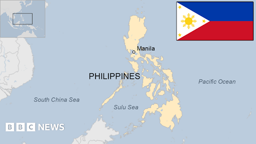
The magnitude 7.8 Mindanao earthquake on June 8, 2026, caused by Cotabato Trench subduction, killed 37 people and displaced 20,000. This disaster highlights the Philippines' extreme seismic vulnerability and offers crucial disaster management lessons for India.

Why In News?
On June 8, 2026, a magnitude 7.8 earthquake struck Mindanao in Philippines, triggering tsunamis, displacing over 20,000 people, and killing at least 37 due to tectonic subduction along the Cotabato Trench.
Philippines and Seismic Vulnerability
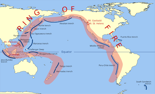
The nation sits directly on the Pacific Ring of Fire, an oceanic arc notorious for extreme seismic faults and volcanic eruptions.
Philippine Mobile Belt interacts with the Eurasian Plate, Philippine Sea Plate, and Sunda Plate, creating complex subduction zones.
The Manila Trench and Philippine Trench host megathrust faults capable of generating magnitude 8+ earthquakes and devastating tsunamis.
Metro Manila faces a "Big One" scenario—a predicted magnitude 7.2 movement along the West Valley Fault that could kill tens of thousands.
Poor urban planning and rapid informal settlements amplify risks; many structures lack earthquake-resistant design.
The country experiences an average of 20 earthquakes daily, though most remain imperceptible.
The 1990 Luzon Earthquake (magnitude 7.7) killed over 1,600 people and exposed systemic preparedness gaps.
What is an Earthquake?
An earthquake is a sudden release of energy in the Earth's lithosphere that creates seismic waves.
Tectonic plates grind past each other at fault lines, and when stress overcomes friction, the ground shakes violently.
The hypocenter (focus) lies underground where the rupture initiates; the epicenter marks the point directly above on the surface.
Primary (P) waves travel fastest through rock, while Secondary (S) waves and surface waves cause maximum destruction.
Magnitude (measured on the Richter scale) quantifies energy release; intensity (Modified Mercalli scale) measures observed effects.
Impact of the Earthquake
Infrastructure Collapse: Buildings, bridges, and roads crumple under seismic stress, especially where codes are weak.
Human Casualties: Thousands perish instantly from falling debris, fires, and tsunamis triggered by undersea quakes.
Economic Disruption: Industries shut down, trade halts, and reconstruction drains national budgets.
Secondary Hazards: Landslides bury villages; liquefaction turns solid ground into fluid, swallowing structures whole.
Psychological Trauma: Survivors suffer long-term mental health crises amid displacement and loss.
Ecological Damage: Coastlines alter, water sources contaminate, and ecosystems collapse.
Earthquake Disaster Management Lessons
Strict Enforcement of Building Codes: India must implement the National Building Code (NBC) rigorously, especially in seismic zones IV and V (Himalayan belt, Gujarat, Northeast).
Early Warning Systems: India should expand the Indian Tsunami Early Warning Centre (ITEWC) and integrate real-time seismic sensors across the Himalayan arc.
Community Preparedness: The Philippines conducts regular drills (e.g., Metro Manila Shake Drill); India must institutionalize similar annual nationwide exercises.
Retrofitting Critical Infrastructure: Hospitals, schools, and dams in high-risk zones require urgent structural reinforcement, as seen in Philippine retrofitting programs.
Land-Use Zoning: India must prohibit construction on liquefaction-prone and fault-trace areas, mirroring Philippine geohazard mapping efforts.
Multi-Hazard Approach: The Philippines links earthquake response with tsunami, fire, and landslide protocols; India should integrate the Sendai Framework across all disaster agencies.
Public Awareness Campaigns: The "Drop, Cover, Hold" campaign in the Philippines proves that simple messaging saves lives; India must replicate this through NDMA outreach.
Insurance and Financial Resilience: The Philippines utilizes catastrophe bonds; India should strengthen the National Disaster Response Fund (NDRF) with parametric insurance models.
Source: THEHINDU
|
PRACTICE QUESTION Q. Consider the following statements regarding the seismic geography of the Philippines: I. The Philippine archipelago sits tectonically between the Sunda Plate and the Philippine Sea Plate. II. The Cotabato Trench represents a major terrestrial strike-slip fault system. Which of the statements given above is/are correct? (a) I only (b) II only (c) Both I and II (d) Neither I nor II Answer: (a) Explanation: Statement I is correct: The Philippine archipelago is tectonically sandwiched between two major converging plates: the Sunda Plate (part of the larger Eurasian Plate to the west) and the Philippine Sea Plate (to the east). Statement II is incorrect: The Cotabato Trench is an offshore subduction zone (convergent boundary), not a terrestrial strike-slip fault system. It accommodates a portion of the oblique convergence between the Sunda and Philippine Sea Plates. Major terrestrial strike-slip faults in the country include the Philippine Fault System (a major left-lateral strike-slip system traversing the entire archipelago). |
The Philippines is highly prone to earthquakes because the archipelago sits directly atop a complex network of active tectonic plate boundaries and fault lines, including the colliding Philippine Sea Plate and Eurasian Plate.
India must learn to strictly enforce earthquake-resistant building codes across high-risk Himalayan and urban zones, deploy real-time early warning sensors, and conduct regular community-level evacuation drills.I


© 2026 iasgyan. All right reserved


