Cyclone ‘Shakhti’ highlights the rising frequency of Arabian Sea storms, emphasizing the need for accurate IMD forecasting, resilient infrastructure, community participation, and comprehensive disaster preparedness to mitigate climate change–driven impacts on vulnerable coastal regions.
Copyright infringement not intended
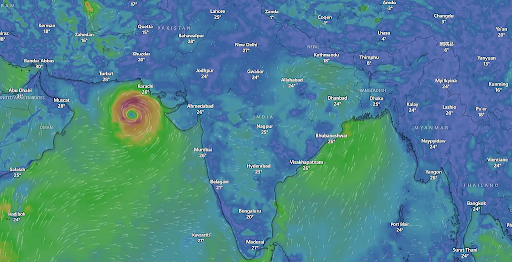
Picture Courtesy: DOWNTOEARTH
The India Meteorological Department (IMD) confirmed the formation of Cyclone ‘Shakhti’ over the northeast Arabian Sea.
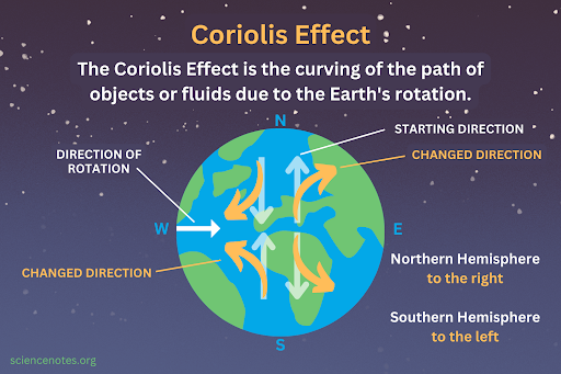
Cyclones are large, powerful, and rotating storm systems that have a low-pressure center. The direction of this rotation is determined by the Earth’s rotation (the Coriolis effect).
There are two main types of cyclones:
Tropical Cyclones
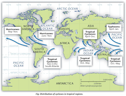
These are intense storms that form over warm tropical oceans, like Cyclone Shakhti. They are known as Hurricanes in the Atlantic, Typhoons in the Pacific, and Cyclones in the Indian Ocean.
Extra-Tropical Cyclones (or Temperate Cyclones)
These form in the mid-latitudes (between 30° and 60°) and are driven by the difference between cold and warm air masses. Western Disturbances that bring winter rain to northwest India are an example of these cyclones.
Specific conditions are necessary for their formation and intensification:
The naming of cyclones is a coordinated international process managed by the World Meteorological Organization (WMO) to avoid confusion and aid in disaster risk communication.
Tropical cyclones in the Bay of Bengal and Arabian Sea strike the coastal states of Tamil Nadu, Andhra Pradesh, West Bengal, Odisha, and Gujarat. Three main elements cause destruction:
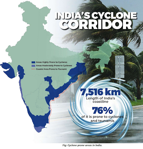
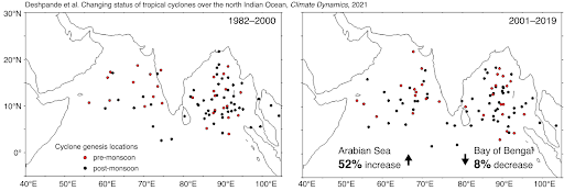
The Arabian Sea is transforming from a relatively calm basin into a major threat zone, altering India's cyclone risk map. This shift is a direct result of global warming.
|
Historical Trend (Pre-2000) |
Modern Trend (Post-2000) |
|
Experienced fewer and weaker cyclones. |
Increased Frequency: A 52% increase was noticed in the frequency of cyclones over the Arabian Sea between 2001 and 2019, and an 8% decrease over the Bay of Bengal. |
|
Cyclones were short-lived and less intense. |
Increased Duration & Intensity: 80% increase in the total duration of cyclones in the Arabian Sea (during the last four decades). The duration of very severe cyclones has increased by 260%. |
|
Generally cooler than the Bay of Bengal. |
Increased Warming: Sea Surface Temperatures (SST) over the Arabian Sea increased by 1.2°C to 1.4°C in recent decades. SST remains abnormally high, around 30°C, fuelling formation. |
Institutional framework
National Disaster Management Authority (NDMA): The apex body, headed by the Prime Minister, sets national policies and guidelines for disaster management. It is responsible for the National Cyclone Risk Mitigation Project (NCRMP) and coordinates with state and district authorities.
India Meteorological Department (IMD): Nodal agency for issuing cyclone early warnings. It monitors tropical cyclones in the Bay of Bengal and the Arabian Sea and provides forecasts and location-specific bulletins to coastal states.
National Disaster Response Force (NDRF): A specialist force deployed for search and rescue operations in affected areas. The NDMA proactively deploys NDRF battalions based on cyclone vulnerability profiles.
State and District Authorities: State Disaster Management Authorities (SDMAs) and District Disaster Management Authorities (DDMAs) are responsible for implementing the national plan at the local level. They conduct evacuations, coordinate relief efforts, and manage shelters.
Indian National Centre for Ocean Information Services (INCOIS): Provides a Storm Surge Early Warning System (SSEWS) for coastal communities and assists the IMD with data.
Multi-stage management process
Pre-disaster: Mitigation and preparedness
During the disaster: Response
Post-disaster: Recovery and reconstruction
India must continuously upgrade its forecasting technology and disaster response protocols to manage the increasing frequency and intensity of severe cyclones emerging from the rapidly warming Arabian Sea.
Source: DOWNTOEARTH
|
PRACTICE QUESTION Q. Warmer waters of the Arabian Sea are overturning historical cyclogenesis trends, making India’s western coast more vulnerable. Critically analyze. 250 words |
The Coriolis force is the deflection of moving objects caused by the Earth's rotation. It provides the necessary spin to initiate the cyclonic rotation. This is why cyclones do not form near the equator, where the Coriolis effect is too weak to create the required rotation.
A storm surge is an abnormal rise in sea level that occurs during a cyclone, above the normal astronomical tide. It is caused by the cyclone's strong winds pushing seawater ashore and is further enhanced by low atmospheric pressure and the shape of the coastline
Cyclones are more frequent in the Bay of Bengal due to higher sea surface temperatures, abundant moisture, low vertical wind shear, and favorable monsoon interactions. Its enclosed geography allows cyclones to intensify, unlike the Arabian Sea, which has stronger wind shear, lower moisture, and less favorable conditions for cyclogenesis.


© 2026 iasgyan. All right reserved


