Border Roads Organisation's Project UDAYAK recently celebrated its 37th Raising Day. Managing 1,457 km of strategic roads, it plays a vital role in national security by developing resilient infrastructure along the LAC and the Indo-Myanmar border.
Why In News?
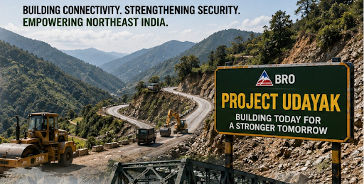
The Border Roads Organisation (BRO) celebrated the 37th Raising Day of Project UDAYAK in Doomdooma, Assam
About PROJECT UDAYAK
The Ministry of Defence operates Project UDAYAK as a specialized territorial wing of the Border Roads Organisation (BRO).
The government officially raised the project on June 1, 1990, at its headquarters in Doomdooma, Assam.
The BRO formed the project by carving out the 48 Border Roads Task Force (BRTF) and the 752 BRTF from existing projects (Vartak and Sewak) to focus specifically on India's far-eastern frontiers.
The name "Udayak" translates to "Rising Sun," symbolizing the operational area where India receives its very first sun rays.
The project functions under the motto "Shramena Sarvam Sadhyam", which means "Everything is achievable through hard work".
The project manages and maintains over 1,457 km of strategic road networks across the easternmost regions of Arunachal Pradesh and parts of Assam.
The project secures and develops border infrastructure along two sensitive international boundaries: the Line of Actual Control (LAC) with China and the Indo-Myanmar border.
Strategic Infrastructure & Key Contributions
Border Fencing: The project executes major border fencing infrastructure along the Indo-Myanmar border to curb insurgent movements and illegal cross-border activities.
Engineering Marvels (Bridges): Project UDAYAK constructs technologically challenging bridges that reduce travel time and connect rugged terrains:
Aviation & Civil Infrastructure: The project builds broader civil-military assets, including the resurfacing of the Dibrugarh Airfield, constructing accommodations for the Assam Rifles and Sashastra Seema Bal (SSB).
Innovative Technologies: The project integrates sustainable practices, such as utilizing shredded plastic in the asphalt concrete construction of the Roing-Koronu-Paya road.
National Connectivity Schemes: The project executes major segments of the Bharatmala Pariyojana and the Special Accelerated Road Development Programme for North East (SARDP-NE).
Significance for Security & Development
Rapid Troop Deployment: By building reliable infrastructure in hostile terrains, the project guarantees the Indian Army's mobility and rapid deployment capabilities against adversarial threats.
Socio-Economic Development: The project bridges the geographical gap to provide last-mile connectivity up to the LAC, linking remote tribal hamlets to essential markets, healthcare, and education.
Civil-Military Integration: The project routinely conducts community outreach programs, including medical camps, Swachhata Abhiyan, and road safety awareness campaigns to foster goodwill among local populations.
Source: PIB
|
PRACTICE QUESTION Q. Consider the following statements regarding 'Project UDAYAK':
Which of the statements given above is/are correct? A) 1 only B) 2 only C) Both 1 and 2 D) Neither 1 nor 2 Answer: B Explanation: Statement 1 is Correct: Project UDAYAK is a project of the Border Roads Organisation (BRO) raised on June 1, 1990, at Doomdooma, Assam. It is tasked with developing and maintaining strategic road infrastructure in the North-East region of India, specifically in the easternmost parts of Arunachal Pradesh and Assam. Statement 2 is Incorrect: Project UDAYAK is responsible for infrastructure along the Line of Actual Control (LAC) with China and the Indo-Myanmar border, not the Line of Control (LoC) with Pakistan. The LoC is primarily the responsibility of other BRO projects (such as Project Beacon or Project Sampark in J&K). Statement 3 is Correct: The project was instrumental in constructing the 426.60-meter-long Diffo Bridge over the Diffo River on the Roing-Koronu-Paya road. This bridge provides uninterrupted connectivity between the Dibang Valley and Lohit Valley regions of Eastern Arunachal Pradesh. |
Project UDAYAK is a specialized territorial wing of the Border Roads Organisation (BRO) tasked with developing and maintaining a vast strategic road network and bridge infrastructure in the remote and challenging terrains of Northeast India.
Its geographical coverage spans over 1,457 km in the easternmost regions of India, encompassing parts of Assam and the districts of Anjaw, Lohit, Dibang Valley, Longding, Tirap, and Changlang in Arunachal Pradesh.
The project aims to improve troop mobility and logistics along the Line of Actual Control (LAC) with China and the Indo-Myanmar border. It also executes major border fencing to curb insurgency and provides last-mile connectivity to remote border hamlets.

© 2026 iasgyan. All right reserved