India experiences sudden, intense flash floods from extreme rainfall, cloudbursts, and glacial lake outbursts, aggravated by saturated soil. Hotspots include the Himalayas, West Coast, and Central India. Climate change is increasing their frequency and intensity, causing damage and over 5,000 deaths annually.
Copyright infringement not intended
Picture Courtesy: TIMESOFINDIA
Intense monsoon rainfall has recently caused flash floods and landslides across Jammu and Kashmir, Himachal Pradesh, and Uttarakhand.
It is a local flood caused by heavy or excessive rainfall in a short period of time.
Between 2020 and 2022, flash flood events increased from 132 to 184, according to the Union Ministry of Jal Shakti.
Climatic Factors
Cloudbursts: Extreme precipitation exceeding 100 mm/hour over a small geographical area cause flash floods in hilly terrains.
Glacial Lake Outburst Floods (GLOFs): Sudden release of large volumes of water from glacial lakes, by melting glaciers due to global warming.
Landslide Lake Outburst Floods (LLOFs): Break of lakes formed by landslides, lead to flash floods.
Climate Change: Rising temperatures increase the atmosphere's moisture-holding capacity by about 7% per 1°C rise, leading to more intense and frequent rainfall.
Intense Rainfall: Lengthy low-intensity rainfall or multi-day rainfall, combined with wet antecedent soil conditions, initiates most (about 3/4th) flash floods, while only 25% solely caused by extreme precipitation. (Source: Journal Nature Hazards)
Rapid Snowmelt: Sudden increases in temperature or rain on snow can cause flash floods.
Geological Factors
Topography: Steep slopes, high relief, and fragile geology accelerate runoff, making regions like the Himalayas vulnerable.
Soil Quality/Ground Cover: Rocks and loamy, flat soils can prevent moisture penetration, can lead to rapid flash flooding.
Anthropogenic Factors (Man-made)
Development Activities: Unplanned road construction, building in uninspected areas, hydroelectric power projects (clearing trees, blasting, tunnelling), mining, and forest encroachment, destabilize the natural ecosystem and alter natural water flows.
Population Growth & Tourism: Increasing population and tourist numbers in hilly regions, more development and encroachment, resulting flood.
Unscientific Land Use Planning: Encroachment on floodplains, waterways, and wetlands reduces the capacity of rivers and natural flood sinks.
Humanitarian Impact: Flash floods cause a high number of fatalities, exceeding 5,000 deaths annually in India. (Source: Indian Express)
Economic Impact: Average annual monetary losses due to floods are around Rs 5649 crores. Indian floods account for over half of climate-related disasters, causing $54.63 billion in damages between 1990 and 2017. (NITI Aayog Report).
Infrastructure Damage: Around 1.2 million houses are annually damaged by floods. Major events like the Uttarakhand flood of 2013 resulted in an estimated Rs 50,000 crore in infrastructural loss.
Agriculture and Livelihoods: An average of 3.94 Mha of cropped area is affected annually. Loss of cattle life around 618,248 annually. Livelihoods, mainly for daily wage workers, domestic helpers, rag pickers, and street vendors, are impacted. (NITI Aayog Report)
Environmental Impact: Flood Control Infrastructure (FCI) leads to degradation of local riverine ecosystems and cause ecological impacts by prioritizing flood control over ecological conservation and restoration.
Governance/Administrative Impact: Floods place burden on disaster management agencies, also creates pressure on state finances.
Rising global mean temperatures link to increased moisture-holding capacity of the atmosphere, results in more intense and frequent rainfall events.
Between 1981-2020, extreme precipitation increased by 56% during monsoon, 40% post-monsoon, and 12.5% in winter seasons. (Source: IIT Gandhinagar)
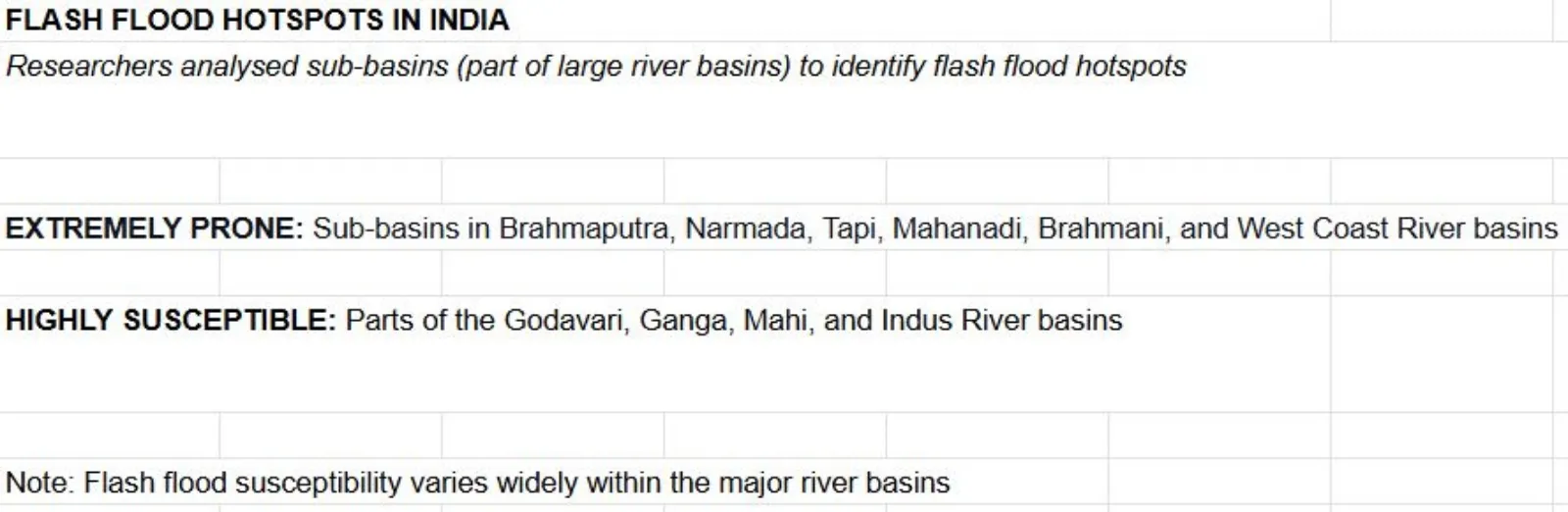
Between 1980-2018, over 75% of flash floods occur during the summer monsoon season (June–September). Most flash floods occur in the Brahmaputra, Ganga, and Krishna River basins.
Warming climate can lead to new flash flood hotspots in the future.
 Steps taken by Government to address Flash Flood
Non-Structural Measures
Flood Forecasting and Early Warning Systems (EWS): Central Water Commission (CWC) operates around 1600 hydro-meteorological sites across 20 river basins for flood forecasting and warning.
Flood Plain Zoning: Limiting flood-prone areas and setting permissible developments to minimize damage.
Community Radio Policy: 'Mandakini Ki Awaz', the first radio station in Uttarakhand set up by local people in Rudraprayag, covers about 350 villages, sharing emergency information and timely updates.
NDMA GLOFs Guidelines 2020: Focus on improving administrative response, using scientific information, developing early warning systems, and capacity building.
NDMA Guidelines for Urban Floods: Encouraging cities to integrate flood mitigation plans with overall land use policy and master planning.
Structural Measures
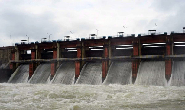
Reservoirs: Moderate flood intensity by storing water during high flows and releasing it later.
Embankments: Confine river flows, preventing overflow and reducing damage.
Channel Improvement: Desilting, dredging, and lining river channels increase their carrying capacity.
Interlinking of Rivers: Projects for interlinking rivers are being pursued in a time-bound manner to divert floodwaters to water-scarce areas.
Difficult Terrain and Accessibility: Hilly regions difficulties due to challenging terrain, restricted accessibility, and low monitoring levels, hindering flood risk management.
Inadequate Data and Monitoring: Lack of adequate data, and an insufficient number of hourly rainfall observing systems hamper effective flood detection and forecasting.
Forecasting Difficulty: Flash floods occur due to intense, short blasts of rainfall, difficult to measure their intensity and duration for accurate forecasting.
Incomplete Policy Frameworks: Uttarakhand State Disaster Management Plan 2020 does not adequately include policies for cloudbursts, glacial lakes, or climate change risk management, which are major causes of flash floods.
Infrastructure Limitations: Flood Control Infrastructure (FCI) requires consistent, expensive maintenance, many flood protection structures suffer from inadequate maintenance, leading to repeated failures.
Inter-Agency Coordination Gaps: Lack of inter-agency coordination between national, state, and district levels creates gaps in effective management.
Financial Disparity: India spends insufficient funds on flood mitigation compared to relief measures.
Multipurpose Dams: Many dams serve multiple purposes (flood control, irrigation, hydropower), making it difficult for states to prepare specific Emergency Action Plans (EAPs) for flood scenarios.
Urban Drainage Issues: Many cities lack proper storm water drainage systems, overburdened sewage networks.
|
Why Himalayan region is prone to flash floods? Natural Factors Intense Rainfall
Geological Vulnerabilities
Circular basins: Contribute to rapid runoff, facilitating flash flood occurrences compared to elongated basins. Complex drainage patterns: Dense networks or poorly defined channels, influence the distribution and intensity of flooding. Human Impact
The NITI Aayog report recommended, for strict Flood Plain Zoning, mandatory Disaster Impact Assessment (DIA) with Environmental Impact Assessment (EIA), for large projects in ecologically sensitive regions, and comprehensive landslide risk zonation mapping. |
Integrated Disaster Management: Focus on managing natural disasters such as cloudbursts, landslides, earthquakes, and avalanches, as they trigger flash floods.
Policy Integration and Enforcement
Enhanced Forecasting and Warning Systems
Organizational and Financial Reforms
Integrated River Basin Management: Managing river basin resources as a whole, moving away from fragmented, localized efforts.
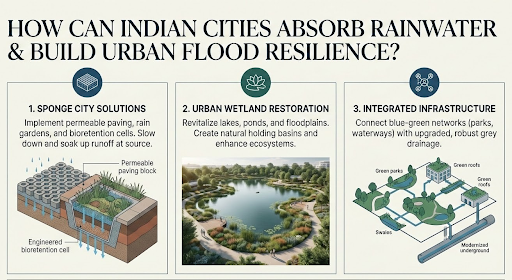
"Room for the River" Concept: Flood management stresses minimizing destruction by "leaving the room of the river," allowing natural processes to occur, and creating wetlands and lakes.
Flood Proofing and Infrastructure Revamping: Constructing buildings on fills, using water-resistant materials, or designing structures that can float.
Urban Open Spaces and Floodplain Restoration: Direct floodwater to green spaces for temporary retention. Floodplain restoration involves planting native vegetation, and allowing natural processes to restore ecological functions.
Flash floods represent a recurrent and devastating natural disaster, with their frequency and intensity escalating due to climate change and uncontrolled anthropogenic activities.
Current management approaches have largely focused on structural measures, but past events demonstrate their insufficiency.
Moving forward, India needs a paradigm shift towards comprehensive, climate-resilient strategies that prioritize non-structural measures like advanced early warning systems, strict floodplain zoning, and community-based preparedness.
Source: TIMESOFINDIA
|
PRACTICE QUESTION Q. Flash floods are often a man-made disaster masked as a natural one. Critically analyze. 250 words |
Flash floods are sudden, intense floods of short duration that occur within six hours of heavy or extreme rainfall, rapid snowmelt, glacial lake outbursts (GLOFs), or dam/levee failures. They are characterized by rapid onset, high intensity, and localized impact.
Unlike river floods, flash floods have a rapid onset and decline, high intensity, unpredictability, and more localized impact, particularly in hilly and mountainous areas. They also cause the highest mortality rate compared to riverine and coastal flooding.
GLOFs are sudden, large-volume floods resulting from the rupture of glacial lakes in high-elevation glacier basins, often formed or expanded due to landslides and global warming.


© 2026 iasgyan. All right reserved