

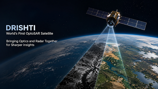
Mission Drishti is the world’s first OptoSAR satellite, developed by the Indian startup GalaxEye. It uniquely combines optical and SAR sensors for all-weather Earth observation. Despite a recent solar storm anomaly, it marks a major milestone for India’s private space ecosystem.
Why In News?
The Mission Drishti spacecraft encountered a severe anomaly and lost communication following an extreme geomagnetic solar storm.
What is Mission Drishti?
Mission Drishti is India’s largest privately developed Earth observation (EO) satellite.
It is recognized as the world’s first OptoSAR satellite.
Developed by: GalaxEye, a Bengaluru-based space technology startup founded by IIT Madras alumni.
Launch Details: Successfully launched in May 2026, aboard a SpaceX Falcon 9 rocket from Vandenberg Space Force Base, USA.
OptoSAR Technology
Dual-Sensor Integration: The satellite integrates Electro-Optical (EO) cameras and Synthetic Aperture Radar (SAR) into a single operational platform.
Complementary Strengths: While optical sensors capture high-resolution, intuitive visual images, they are limited by cloud cover and nighttime. SAR uses radar pulses to generate images in all-weather, day-and-night conditions.
Simultaneous Capture: Typically, data from optical and SAR satellites must be manually aligned, which causes temporal and spatial gaps. Mission Drishti solves this by capturing optical and radar data of the same location simultaneously.
Key Features & Components
Orbit: Designed to follow a Sun-synchronous Low Earth Orbit (LEO).
SAR Sensor: An active microwave sensor operating in the X-band (VV polarization) that provides high-resolution imaging up to 0.9 m.
Multispectral Imaging Sensor (MSI): A passive optical sensor that captures data across seven spectral bands with a 3.6 m resolution.
OptoSAR Fusion Payload: Generates 1.8 m fused, analysis-ready imagery in a single pass, enhancing data accuracy and eliminating the need for post-processing.
Applications
Defence and Strategic Utility: Enhances continuous border surveillance, maritime domain awareness, and military intelligence.
Civilian and Economic Use: Highly beneficial for disaster management, agricultural planning, environmental monitoring, and urban development. It ensures consistent monitoring even during India's heavy monsoon seasons.
Boosting the Space Economy: Demonstrates the growing sovereign capability of India’s private space sector under the facilitation of IN-SPACe, positioning India as a competitive provider of global Earth observation data.
Current Status
Mission Drishti established communication and completed a major portion of its planned Launch and Early Orbit Phase (LEOP).
Recently, it lost communication following a geomagnetic solar storm.
Source: THEHINDU
|
PRACTICE QUESTION Q. Consider the following statements regarding 'Mission Drishti': 1. It is India's largest privately developed Earth observation satellite. 2. It operates exclusively using optical imaging sensors to penetrate heavy cloud cover. 3. It was successfully placed into orbit by the Indian Space Research Organisation (ISRO) using a PSLV. Which of the statements given above is/are correct? (a) 1 only (b) 1 and 2 only (c) 2 and 3 only (d) 1, 2 and 3 Answer: (a) Explanation: Statement 1 is correct: Mission Drishti is identified as India's largest privately developed Earth observation satellite, weighing approximately 190 kg. It was developed by the Bengaluru-based space-tech startup GalaxEye Space. Statement 2 is incorrect: The satellite does not operate "exclusively" using optical sensors. Instead, it employs a proprietary hybrid technology called "OptoSAR", which fuses Multi-Spectral (optical) sensors with Synthetic Aperture Radar (SAR) on a single platform. While optical sensors provide high-resolution visual clarity, they cannot see through clouds; it is the SAR component that allows the satellite to penetrate heavy cloud cover and capture images at night. Statement 3 is incorrect: The satellite was not launched by ISRO using a PSLV. It was successfully launched aboard a SpaceX Falcon 9 rocket from the Vandenberg Space Force Base in California, USA, on May 3, 2026. |
OptoSAR technology is a dual-sensor satellite architecture that fuses Optical Imaging (which provides high-resolution, color visual data) with Synthetic Aperture Radar (SAR) (which uses radar pulses to image the earth through clouds and darkness). This provides a single, highly accurate, and all-weather composite image.
Drishti is the world's first satellite to physically place both an optical camera and a SAR sensor on the exact same platform. These sensors flew on separate satellites, creating time delays (temporal gaps) and angle differences (parallax errors) when analysts tried to merge the data.
SAR is an active microwave sensor technology that beams radar signals down to Earth and measures the reflected return. Unlike optical cameras that need sunlight, SAR works perfectly at night and can penetrate severe weather events, fog, and thick clouds, making it vital for continuous surveillance.
During natural disasters like cyclones or monsoon floods, skies are heavily overcast, rendering optical satellites useless. OptoSAR utilizes its radar component to accurately map flood inundation and infrastructure damage through the clouds, instantly fusing it with pre-existing optical data to guide rapid, precision rescue operations.





© 2026 iasgyan. All right reserved