The Aravalli Range, North India’s crucial dust and desertification shield, faces severe degradation. Recent Supreme Court rulings redefining the hills for mining regulations have sparked ecological concerns, amplifying the urgent need for the Aravalli Green Wall eco-restoration project.
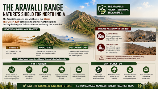
The Aravalli Range acts as a vital barrier that blocks Thar Desert dust from reaching the Indo-Gangetic plains, but illegal mining and deforestation are weakening this protection.
The Aravalli Range is a 670-kilometer-long mountain belt stretching from Delhi through Haryana and Rajasthan to Ahmedabad, Gujarat.
Dating back 2 billion years, it is the oldest fold mountain system in India.
It features the highest peak, Guru Shikhar (1,722 meters) in Mount Abu.
How Does the Aravalli Range Act as a Natural Shield Against Thar Desert Dust?
The Aravallis function as a natural physical barrier between the Thar Desert and the rest of the country.
Geographic Barrier: The range separates the arid western Asiatic desert region from the true peninsula of the subcontinent.
Wind Regulation: Its canopy and physical structure regulate wind velocity, slowing the eastward drift of desert sand toward the Indo-Gangetic plains.
Climate Stabilization: The range stabilizes micro-climates and helps maintain humidity across Gujarat, Rajasthan, Haryana, and Delhi.
Atmospheric Shield: It prevents the incursion of sand into Delhi-NCR, protecting the region's air quality from natural mineral dust pollutants.
Formation of Gaps: Natural erosion and human-led destruction have created 12 major gaps in the range, extending from the Magra hills (Ajmer) to the Khetri-Madhogarh hills (Jhunjhunu) and into Mahendragarh (Haryana).
Breach of Barrier: These breaches act as corridors, enabling desert dust from the Thar to drift directly into the Delhi-NCR region.
Loss of Canopy: Deforestation reduces the "friction" that normally slows down dust-laden winds.
Vanishing Hillocks: The disappearance of low-elevation hills due to illegal quarrying removes physical obstructions that previously trapped sand.
Hill Disappearance: A 2018 Supreme Court-appointed committee found that in Rajasthan, 31 out of 128 Aravalli hills disappeared over 50 years due to illegal quarrying.
Hydrological Disruption: Mining activities damage aquifers and dry up lakes, compromising the range's ability to recharge groundwater.
Fragmentation: The ecological richness is now restricted to fragmented forest patches, reducing the range's overall resilience.
Impact of the "100-Metre Rule": Supreme Court definition (2025) classifies only landforms rising 100 metres above local relief as Aravalli Hills. This excludes 91.3% of mapped hills from strict protection, opening them to further exploitation.
Drivers of Aravalli Degradation
Extensive Mining: The Aravallis are a repository of 70 different minerals. Commercial exploitation of Zinc, Lead, Copper, and Marble causes massive topographical changes.
Critical Mineral Demand: High demand for strategic minerals (Lithium, Rare Earth Elements, Tin, Graphite) for energy transition puts additional pressure on the landscape.
Urbanization and Encroachment: Rapidly growing towns like Gurugram, Faridabad, and Sohna cause habitat loss through construction and infrastructure development.
Population Pressure: Increased human and livestock density exerts "tremendous pressure" on biodiversity, leading to overgrazing and fuel-wood extraction.
Modernization of Agriculture: Indiscriminate use of chemical fertilizers and excessive underground water extraction for irrigation degrade the foothills.
Consequences for the Indo-Gangetic Plains
The degradation of the Aravalli range triggers a cascade of environmental crises for Northern India.
|
Impact |
Consequences for the Indo-Gangetic Plains |
|
Water Security |
Failure to recharge fissured rock aquifers, which provide approximately 2 million litres of water per hectare to surrounding cities. |
|
Desertification |
Eastward movement of desert sands, compromising agricultural productivity in Alwar, Haryana, and Uttar Pradesh. |
|
Air Quality |
Heightened levels of particulate matter (dust) in Delhi-NCR, worsening an already severe air pollution crisis. |
|
Biodiversity |
Shrinking wildlife corridors and increased human-wildlife conflict as species lose their dry deciduous and semi-arid habitats. |
|
Agriculture |
Loss of fertile topsoil due to combined water and wind erosion, forming sandy ravines on the eastern side of the range. |
Inconsistent Definitions: Historically, different states used different criteria for "Aravallis," making uniform enforcement difficult.
Illegal Mining Mafias: Prohibitions often push mining underground, empowering local mafias and making regulation harder.
Indifferent Local Attitudes: Surveys indicate a lukewarm attitude toward conservation among some villagers due to the declining direct contribution of biodiversity to their immediate quality of life.
Economic Conflict: The range's status as a mineral repository creates a clash between industrial development goals and environmental preservation.
Aravalli Green Wall Project: Aimed at restoring the landscape to check desertification.
Management Plan for Sustainable Mining (MPSM): A court-mandated plan to identify permissible areas versus ecologically sensitive, conservation-critical zones where mining is strictly prohibited.
National Biodiversity Strategy and Action Plan (NBSAP): Initiated in 2000 to promote integrated action in biodiversity conservation and equitable sharing of benefits.
Joint Forest Management (JFM): Reviving the traditional relationship between local communities and forests through Village Forest Protection Committees.
Judicial Intervention: The Supreme Court has placed a moratorium on new mining leases until comprehensive geographical mapping and the MPSM are finalized.
Comprehensive Mapping: Undertake geographical mapping of the entire landscape to demarcate all valid hills and ranges based on scientific (not just elevation) criteria.
Restore Ecological Gaps: Prioritize reforestation in the 12 identified gaps to create a continuous physical and biological barrier against desertification.
Revive Indigenous Knowledge: Re-incorporate the local knowledge systems and cultures that historically conserved the biodiversity of the region.
Sustainable Resource Use: Implement judicious utilization of fuel, fodder, and medicinal plants through community-led management to create local stakes in conservation.
Legal Protections: Strengthen legal frameworks to prevent the diversion of forest lands around protected areas like Sariska Wildlife Sanctuary.
The Aravalli Range serves as an ecological shield against desertification and water scarcity, requiring urgent, uniform protection and restoration to safeguard the environmental future of Northern India.
Source: INDIANEXPRESS
|
PRACTICE QUESTION Q. Consider the following statements regarding the Aravalli Range:
Which of the statements given above are correct? A) 1 and 2 only B) 2 and 3 only C) 1 and 3 only D) 1, 2, and 3 Answer: D Explanation: Statement 1 is correct: The Aravalli Range is the oldest fold mountain system in India and among the oldest in the world, having formed during the Proterozoic/Paleoproterozoic eras (roughly 2.5 to 1.7 billion years ago). Statement 2 is correct: The Supreme Court adopted a uniform definition stating that landforms rising at least 100 metres above the local relief qualify as Aravalli Hills. Statement 3 is correct: The Aravalli Green Wall Project aims to establish a 1,400 km long, 5 km wide green belt buffer stretching from Gujarat to Haryana (passing through Rajasthan and Delhi) to combat desertification and land degradation. |
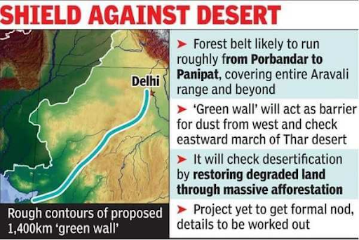
It is a proposed 1,400 km-long and 5 km-wide green ecological corridor from Porbandar, Gujarat, to Panipat, Haryana, designed to combat desertification, act as a dust barrier, and restore degraded land.
The Aravallis act as a natural physical barrier that slows the eastward expansion of the Thar Desert, protecting the heavily populated Indo-Gangetic plains and Delhi-NCR from intense dust and sand storms.
It is not entirely banned. While new leases for general minerals are paused until a Management Plan for Sustainable Mining (MPSM) is finalised, exemptions exist for critical, strategic, and atomic minerals.


© 2026 iasgyan. All right reserved