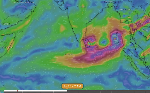
Two developing systems in the Bay of Bengal may trigger a Fujiwhara interaction, where their circulations influence each other and create major uncertainty in the storm’s final path and strength. Divergent IMD and global model forecasts heighten risks, making coordinated early warnings essential for vulnerable coastal regions.
Copyright infringement not intended
Picture Courtesy: DOWNTOEARTH
Meteorological models forecast two cyclonic systems in the Bay of Bengal, potentially causing the rare Fujiwhara effect if they form closely.
The Fujiwhara effect is a meteorological phenomenon where two nearby cyclonic storms orbit each other and influence each other's path and intensity.
Named after Japanese meteorologist Sakuhei Fujiwhara, who first described it in 1921, this interaction occurs when tropical cyclones come within approximately 1,400 kilometers of each other.
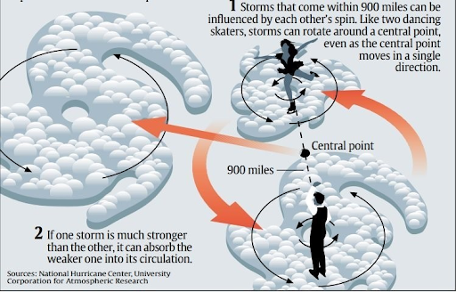
Potential Outcomes of the Fujiwhara Effect
Merging: The two cyclones spiral towards a common center and combine into a single, larger storm. This is rare and usually happens when they are within 300 km of each other.
Absorption: A stronger or larger storm can dominate the interaction and absorb the weaker one, intensifying in the process.
"Dancing" or Orbiting: Storms of similar strength may rotate around a common central point before moving off on separate paths. This rotation is counter-clockwise in the Northern Hemisphere.
Weakening: The interaction can disrupt the atmospheric structure of one or both storms, leading to their weakening or dissipation.
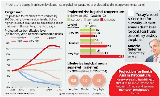
Rising Sea Temperatures: Global warming has led to a steady increase in the heat content of the upper oceans. The IPCC's Sixth Assessment Report (AR6) confirms that the global proportion of major tropical cyclones (Category 3-5) has likely increased over the last four decades.
Increased Moisture and Rainfall: A warmer atmosphere holds more moisture, resulting in heavier rainfall during cyclonic events. The IPCC AR6 states with high confidence that the average rain rates associated with cyclones are increasing in a warming world.
Enhance Forecasting Capabilities: Fund advanced research and supercomputing to enhance numerical weather models' prediction of rapid intensification and multi-storm interactions.
Strengthen Regional Cooperation: Enhance data sharing and coordinated response mechanisms through platforms like the BIMSTEC Centre for Weather and Climate (BCWC).
Mainstream Climate Resilience: Integrate climate change adaptation and disaster resilience into all developmental planning (urban, coastal, etc.) for sustainable growth.
Empower Local Institutions: Strengthen local governance (Panchayats, municipalities) and community organizations, as they are essential first responders in disasters.
Source: DOWNTOEARTH
|
PRACTICE QUESTION Q. Consider the following statements regarding the Fujiwhara effect: 1. It occurs when two cyclonic vortices are within approximately 1,400 kilometers of each other. 2. In the Northern Hemisphere, storms of similar strength orbit each other in a clockwise direction. 3. The interaction can lead to the merging of two cyclones into a single, larger storm. Which of the statements given above is/are correct? A) 1 and 2 only B) 1 and 3 only C) 3 only D) 1, 2, and 3 Answer: D Explanation: Statement 1 is correct: The Fujiwhara effect occurs when two tropical cyclones are within approximately 1,400 kilometers of each other, at which point their circulations begin to interact. For extratropical cyclones, this distance is around 2,000 kilometers. Statement 2 is incorrect. In the Northern Hemisphere, storms (which are cyclonic vortices) rotate counter-clockwise due to the Coriolis effect. When two such storms interact, they orbit each other in a counter-clockwise direction around a common center. Clockwise rotation of interacting storms occurs in the Southern Hemisphere. Statement 3 is correct. Depending on their relative size and strength, one possible outcome of the Fujiwhara effect is that the two cyclones merge into a single, larger, and often more intense storm, especially if they are of similar strength and come within about 300 km of each other. |
The Fujiwhara effect is a meteorological phenomenon where two nearby cyclonic storms (within about 1,400 km) orbit each other. This interaction can cause them to merge, get absorbed, "dance" around each other, or weaken, making their future path and intensity highly unpredictable.
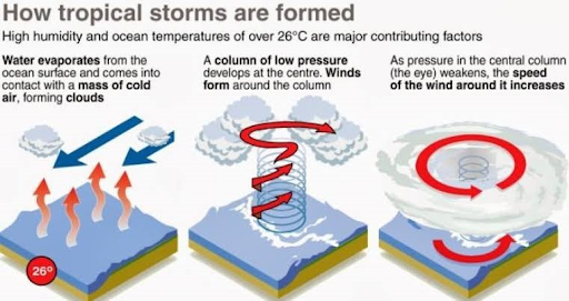
Forecasting is complex due to the Bay's warm sea surface temperatures that fuel rapid intensification, its semi-enclosed geography leading to severe storm surges, and the inherent limitations of numerical weather models in accurately predicting track and rainfall intensity, especially during complex interactions.
Climate change has led to rising sea surface temperatures in the Bay of Bengal, providing more energy for cyclones to become more intense and undergo rapid intensification. A warmer atmosphere also holds more moisture, leading to heavier rainfall and increased flood risk during these events.


© 2026 iasgyan. All right reserved


