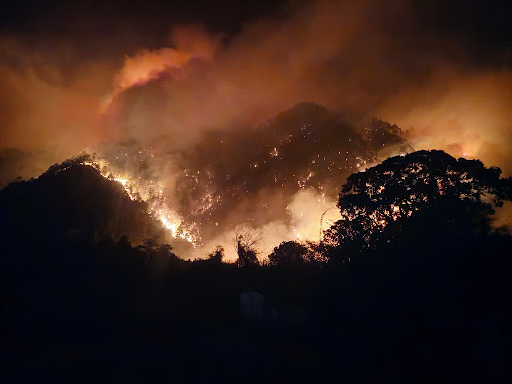
Severe forest fires in Arunachal Pradesh’s Lohit Valley and Walong, and Nagaland’s Dzukou Valley, have prompted Indian Air Force Bambi Bucket operations. Driven by Jhum cultivation, rainfall deficits, and bamboo cover, the fires threaten biodiversity, LAC security, and glaciers.
Copyright infringement not intended
Picture Courtesy: DOWNTOEARTH
Recent major forest fires in ecologically fragile areas of Arunachal Pradesh and highlight the region's extreme vulnerability.
|
Read all about: FOREST FIRES l COMBATING FOREST FIRES IN INDIA l INDIA'S FOREST FIRE WORSENING AS SUMMER APPROACHES |
A forest fire (wildfire or bushfire) is an uncontrolled burn of vegetation in a natural setting (forest, grassland, tundra). It spreads quickly, influenced by wind, topography, and the availability of fuel (dry leaves, twigs, logs).
Types of Forest Fires
Surface Fire: The most common type, burning loose debris on the forest floor such as dry leaves, grass, and shrubs.
Ground Fire: Also called "zombie fires," these burn organic matter beneath the surface (like peat or roots).
Crown Fire: The most intense and dangerous type, where flames jump between treetops (the canopy).
Over 62% of Indian states are highly vulnerable to intense forest fires, per the Council on Energy, Environment, and Water research.
The Forest Survey of India (FSI) reports that nearly 10.66% of India's Forest Cover is highly fire-prone. Forest fire incidents rose by 186% between 2013 and 2021, despite a 0.48% growth in total forest cover.
Extreme fire-prone states: Andhra Pradesh, Assam, Chattisgarh, Odisha, Maharashtra, Madhya Pradesh, Manipur, Mizoram, Nagaland, and Uttarakhand.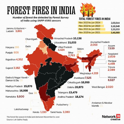
Major fire clusters
North-Western Himalayas: Frequent fires, especially in summer (Uttarakhand, Himachal Pradesh), due to abundant pine forests and flammable litter.
Central India: Fires in dry/moist deciduous Teak and Sal forests are often started to promote the collection of non-timber forest products.
North-East India: Widespread annual fires primarily caused by the traditional practice of shifting cultivation (slash and burn) in community-owned forests.
Western Ghats and Eastern Ghats: Fires occur frequently in moist deciduous and semi-evergreen forests due to various human activities, despite a longer wet season.
Causes of Frequent Forest Fires in India
Natural: Lightning strikes are the primary natural cause. Other rare causes include volcanic eruptions or friction from rubbing dry bamboo.
Climate Change: Rising temperatures, prolonged dry spells, erratic monsoons, and unseasonal heat waves increase fire susceptibility. Drier forests and more common El Niño events worsen conditions.
Human Activity: Expanding agriculture, illicit land clearing (slash-and-burn), infrastructure projects (roads/railways), improper waste disposal (pilgrimage routes), and increased tourism footfall lead to accidental and deliberate ignitions.
Weak Systems: Inadequate fire surveillance, outdated response mechanisms, weak law enforcement, lack of real-time monitoring, and a shortage of fire stations exacerbate the crisis.
Flammable Vegetation: India's biodiversity, particularly dry deciduous, pine, grassland, and bamboo forests, is highly fire-prone. Resin-rich pine needles act as natural fuel.
Lack of Awareness and Community Involvement: Rural communities often lack awareness of fire risks; traditional control practices have declined, and coordination between officials and locals is weak.
Poor Technological Integration: Delayed alerts, lack of AI-driven predictive models, real-time drone surveillance, and weather-based forecasting hamper preparedness.
Positive Impacts: Limited natural forest fires offer ecological benefits
Negative Impacts
National Action Plan on Forest Fires (NAPFF)
Launched by the Ministry of Environment, Forest and Climate Change (MoEFCC), the NAPFF focuses on informing, enabling, and empowering forest fringe communities.
Central Monitoring and Monitoring Systems
Financial and Operational Support
Aerial Firefighting Response
Deployment of IAF Mi-17 V5 helicopters equipped with Bambi Buckets (collapsible buckets carrying thousands of litres of water) is the standard protocol for controlling fires in inaccessible, high-altitude regions.
Climate Change & Environmental Factors
Rising temperatures, prolonged dry spells, and erratic rainfall have made forests significantly more flammable. Heatwaves now cause fires even in traditionally cooler regions like the Himalayas.
Biological Vulnerabilities
The expansion of monoculture plantations (like pine or eucalyptus) provides highly flammable fuel loads compared to native broad-leaved forests, which retain more moisture and act as natural firebreaks.
Logistical Hurdles
Many fires occur in rugged, inaccessible terrain where roads are lacking, making it nearly impossible for firefighting crews to reach spots quickly.
Delayed Ground Response
While satellite alerts are instantaneous, verifying the fire on the ground (ground truthing) is delayed due to poor road connectivity in remote districts.
Resource Deficit
State forest departments in the Northeast are understaffed by 30-40% and lack modern firefighting equipment like fire-retardant suits and blowers (Source: Parliamentary Standing Committee)
Inconsistent Funding
Financial support for the Forest Fire Prevention and Management Scheme (FFPMS) has fluctuated, with budgets being reduced in recent years, hindering long-term planning.
Promote Sustainable Jhum
Instead of a blanket ban, promote scientific management of Jhum cultivation. This includes creating pre-cut fire lines before burning and encouraging a transition to agro-forestry, inspired by successful models like the Nagaland Empowerment of People through Energy Development (NEPED) project.
Integrate Traditional Knowledge
Integrate traditional knowledge, like Australia's "Cultural Burning" for fuel reduction, with modern science, as recommended by the National Disaster Management Authority (NDMA).
Establish a Dedicated Force
States should create dedicated forest fire response teams, as recommended by the N.K. Singh Committee on Disaster Risk Financing. This would reduce over-reliance on the Army and IAF during emergencies.
Enhance Early Warning Systems
The IMD and FSI must collaborate to issue location-specific "Fire Weather Indices" to district authorities before the dry season. This would enable pre-emptive measures and resource deployment.
AI and Satellite Early Warning
Utilize AI predictive models and real-time satellite monitoring (MODIS, SNPP-VIIRS) for fire-prone zone detection. Drones with thermal imaging can direct firefighting.
Ban Destructive Activities in Eco-Sensitive Zones
Strictly regulate mining, road expansion, and hydroelectric projects. Implement No-Go Zones and stricter Environmental Impact Assessments (EIAs). Promote eco-friendly alternatives (underground cabling). Example: Supreme Court involving Niyamgiri forest dwellers on mining.
Promote Sustainable Tourism
Regulate ecotourism with responsible guidelines, low-impact infrastructure, and carrying capacity limits. Involve local communities (homestays, nature guides). Example: Kaziranga National Park.
Recurring forest fires in Northeast India, driven by climate change and unsustainable land use, demand a strategic shift from emergency air response to local community empowerment, enhanced state capacity, and scientific management for long-term ecological and strategic security.
Source: DOWNTOEARTH
|
PRACTICE QUESTION Q. Discuss the strategic and ecological implications of recurrent forest fires in the Himalayan region. 150 words |
Northeast India is vulnerable due to a combination of factors: the prevalence of "slash and burn" (Jhum) agriculture which often spreads uncontrollably, significant winter rainfall deficits creating dry conditions, and the presence of highly inflammable vegetation like bamboo.
Farmers practice Jhum (shifting cultivation) by burning vegetation to clear land for sowing between February and March. Due to high winds and dry winter conditions, these intended controlled burns often escape into surrounding forests, causing large-scale wildfires.
Forest fires release Black Carbon, a pollutant. When this deposits on Himalayan glaciers, it darkens the snow/ice surface, absorbing more heat and accelerating glacial melting, which poses a threat to long-term water security in the region.


© 2026 iasgyan. All right reserved


