The Supreme Court’s 100-metre elevation rule for the Aravallis threatens over 90% of India's oldest fold mountains. Urgent landscape-level conservation and the Aravalli Green Wall Project are critical to prevent desertification, water scarcity, and severe pollution across North-West India.
The Rajasthan Forest Department's plan to use dynamite for afforestation threatens the ancient Aravalli ecosystem, which needs protection from human interference to recover.
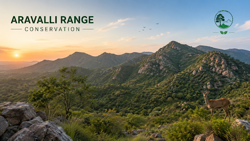
Geological Origin: The Aravallis is one of the oldest mountain systems on Earth, originating during the Paleoproterozoic era nearly 2.5 to 3.2 billion years ago.
Tectonic Formation: Intense collisions between the Marwar Craton and the Bundelkhand Craton folded the Earth's crust, creating metamorphic rocks including granite, marble, schist, and quartzite.
Geographic Extent: The system stretches approximately 670 to 692 kilometres from Himmatnagar (Gujarat) to the Delhi Ridge.
State Coverage: The range spans Gujarat, Rajasthan (home to the highest peak, Guru Shikhar at 1,722 m), Haryana, and Delhi, serving as a geographic divider between the Thar Desert and the fertile plains.
Green Wall: The range acts as a robust barrier, physically blocking wind-blown desert sands and preventing the eastward expansion of the Thar Desert.
Groundwater Recharge: The Central Ground Water Board (CGWB) confirms that fractured quartzite formations recharge 20–30% of the groundwater for the National Capital Region (NCR).
Biodiversity Hotspot: The ecosystem supports 22 wildlife sanctuaries and 4 tiger reserves, providing a vital migratory corridor for species like the Indian Leopard and striped hyena.
Climate Regulation: Dense tree cover reduces particulate matter (PM) concentrations by 16.5–26.7%, while the range functions as a massive regional carbon sink.
Illegal Mining: Unregulated extraction of quartz, silica sand, and limestone causes irreversible damage. The Central Empowered Committee (CEC) reported in 2018 that 31 hills completely vanished in Rajasthan.
Urban Expansion: The real estate sector systematically clears Natural Conservation Zones (NCZ) to construct high-end residential complexes and resorts across the NCR.
Deforestation: Continuous felling of native trees strips away topsoil, accelerating soil erosion, flash floods, and regional desertification.
Infrastructure Development: Large-scale commercial projects, such as the proposed 10,000-acre jungle safari park in Haryana, prioritize tourism over the preservation of fragile forest lands.
Fragmented Governance: States engage in "definition shopping," using varying criteria for "hills" to bypass environmental clearances for commercial projects.
Weak Enforcement: A localized political-administrative nexus allows mining syndicates to evade pollution control norms despite Supreme Court bans dating back to 2002.
Inadequate Planning: The new 100-metre height rule ignores Forest Survey of India (FSI) slope-based recommendations, stripping protection from roughly 1.6 lakh hillocks in Rajasthan.
Desertification: Currently, 68.3% of Rajasthan undergoes rapid desertification as gaps in the hill range allow hot winds to push dust eastward.
Water Scarcity: Groundwater tables in Haryana and Rajasthan plummet by 1 to 1.5 meters annually, according to 2023 CGWB data.
Air Pollution: Dust storms from the desert account for up to 40% of Delhi’s PM2.5 pollution during summer months.
Economic Loss: The World Bank estimates that environmental degradation costs India $80 billion annually, or 5.7% of GDP.
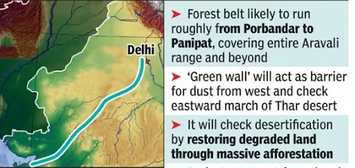
Aravalli Green Wall Project (2023): India aims to create a 1,400 km long, 5 km wide afforestation buffer, planting 50 million native trees like Khejri, Arjuna, and Banyan.
Community Integration: The initiative engages over 10,000 local farmers and Self-Help Groups (SHGs) in agroforestry and wetland restoration.
Sustainable Alternatives: The government promotes the use of Manufactured Sand (M-Sand) and fly-ash geopolymer concrete to reduce reliance on natural quartzite mining.
Technology-Led Governance: Deploy the ISRO Bhuvan platform and AI-enabled drones for real-time surveillance of illegal mining, and strictly implement the Forest Conservation Acts.
Scientific Restoration: Convert abandoned mine pits into native Biodiversity Parks to restore local ecosystems, and generate economic opportunities for locals.
Inter-State Coordination: District-level task forces across Revenue, Forest, and Mining departments to enforce strict logistics oversight and e-challan matching.
Protecting the Aravalli Range requires a holistic, landscape-based ecological strategy rather than arbitrary height metrics. By focusing on scientific restoration and rigorous inter-state oversight, India can secure water resources and climate resilience for millions in the North-West.
Source: INDIANEXPRESS
|
PRACTICE QUESTION Q. Consider the following statements regarding the Aravalli Mountain Range:
Which of the statements given above is/are correct? A) 1 and 2 only B) 2 and 3 only C) 1 and 3 only D) 1, 2, and 3 Answer: B Explanation: Statement 1 is incorrect: The Aravalli Mountain Range is one of the oldest mountain systems in the world, formed during the Precambrian era (specifically the Proterozoic eon), not the Cenozoic era. The Cenozoic era is associated with the formation of young fold mountains like the Himalayas. The Aravallis are now considered residual mountains due to millions of years of denudation. Statement 2 is correct: The Supreme Court of India recently (in November 2025) accepted a definition of the Aravalli Hills which mandated that only landforms with an elevation of 100 meters or more from the local relief classify as Aravalli Hills. This definition was controversial because it potentially excluded lower-elevation hills and ridges from protection, though the court order was subsequently stayed for reconsideration in late December 2025. Statement 3 is correct: The Aravalli Green Wall Project is a major initiative launched to create a 1,400 km long and 5 km wide afforestation belt (green buffer) running from Gujarat to Delhi, covering the states of Gujarat, Rajasthan, Haryana, and Delhi. Its goal is to combat desertification and restore degraded land. |
The Aravallis function as the critical "Green Lungs" for the Delhi-NCR region, regulate the North Indian climate, host biodiversity corridors connecting tiger reserves, and serve as the primary groundwater recharge zone for water-stressed cities.
The ancient range faces severe degradation from unregulated and illegal stone mining, rapid real estate urbanization, large-scale deforestation, and administrative debates over restrictive physical height boundaries.
The hills act as a massive natural geographical wall that blocks dust-laden winds, trapping loose sand on western slopes to prevent the Thar Desert from encroaching eastward into the fertile Indo-Gangetic Plains.
Effective protection requires executing the Aravalli Green Wall eco-buffer project, using drone surveillance to eliminate illegal mines, and establishing independent expert panels to scientifically demarcate and freeze commercial activities across continuous valley landscapes.


© 2026 iasgyan. All right reserved