The unresolved Sir Creek dispute strains India-Pakistan relations, impacting fishermen who unknowingly cross the unmarked maritime boundary. Strategic mistrust, economic interests, and historical tensions keep this marshy region a persistent source of conflict and diplomatic friction between the two nations.

Copyright infringement not intended
Picture Courtesy: INDIANEXPRESS
The Defence Minister issued a strong warning to Pakistan against any "misadventure" in the Sir Creek sector.
Sir Creek was originally named 'Ban Ganga' and was renamed after a British official during the colonial era.
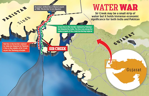
Sir Creek is a 96-km tidal estuary in the uninhabited marshlands of the Rann of Kutch, separating Gujarat in India from the Sindh province in Pakistan.
The dispute originates from differing interpretations of the maritime boundary line between the two nations.
In 1968, an international tribunal settled the larger Rann of Kutch dispute, but it left the question of Sir Creek unresolved.
Strategic Significance
Economic Value

Ecological Importance
Sir Creek is an ecologically sensitive wetland area. It is home to flamingoes and other migratory birds, making its conservation crucial for regional biodiversity.
Bilateral talks to resolve the dispute have been stalled; the last formal round was held in 2012. India advocated for a bilateral resolution based on the Simla Accord of 1972, while Pakistan sought international arbitration.
Recent increase in military presence highlights the urgent need for a peaceful resolution. A mutually agreed demarcation of the boundary could open up opportunities for joint exploration of resources and enhanced maritime security in the region.
A resolution of the Sir Creek dispute could serve as a confidence-building measure in the relationship between India and Pakistan.
The unresolved Sir Creek dispute fuels India-Pakistan tensions, as fishermen face arrests for crossing unmarked waters, reflecting deep mistrust, economic stakes, and historical disagreements.
Source: INDIANEXPRESS
|
PRACTICE QUESTION Q. Consider the following statements about the Sir Creek dispute:
Which of the above statements is/are correct? A) 1 only B) 2 only C) Both 1 and 2 D) Neither 1 nor 2 Answer: D Explanation: Statement 1 is incorrect: The origins of the dispute can be traced back to the pre-independence era, specifically to a 1914 resolution by the British government of Bombay. Statement 2 is incorrect: India claims the boundary should be based on the Thalweg Principle. Pakistan claims the entire creek based on a different interpretation of a 1914 resolution and a map that places the boundary on the eastern bank of the creek. |
Sir Creek is a 96-kilometer long tidal estuary in the marshy wetlands of the Rann of Kutch. It forms a natural boundary between India's Gujarat state and Pakistan's Sindh province before emptying into the Arabian Sea.
The dispute is a long-standing one that dates back to the colonial era, arising from conflicting interpretations of boundary lines established in that period. After the 1947 Partition, the issue of where to draw the maritime boundary in the creek became a major territorial disagreement between the two countries.
Sir Creek's location makes it a sensitive border area for both nations. It provides a direct maritime approach to Pakistan's Karachi Port, a key naval and economic hub. The area is also seen as a potential route for smuggling and terrorist infiltration.


© 2026 iasgyan. All right reserved