Source: INDIA TODAY
Disclaimer: Copyright infringement not intended.
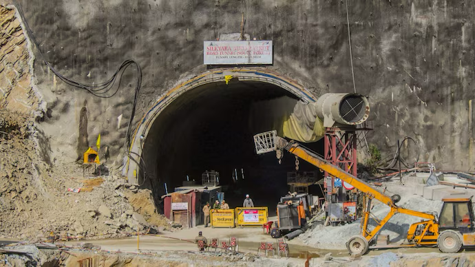
The successful breakthrough of Uttarakhand 4.531 km Silkyara Tunnel marks a milestone in Char Dham Mahamarg project ensuring all-weather connectivity & highlighting Indian infrastructure progress & disaster response capabilities.
|
Parameter |
Details |
|
Location |
Silkyara to Barkot, Uttarkashi district, Uttarakhand |
|
Length |
4.531 km (Not 531 km; Typo corrected) |
|
Highway Section |
Part of NH-134 (formerly NH-94) under Chardham Mahamarg Project |
|
Connectivity |
Connects Dharasu–Yamunotri section enabling access to Yamunotri, Badrinath, Kedarnath |
|
Tunnel Type |
Two-lane, bi-directional road tunnel with separate escape passage |
|
Construction Mode |
EPC (Engineering, Procurement & Construction) |
|
Rock Type Encountered |
90% Phyllite a very weak, metamorphic rock |
|
Tunnel Design Method |
New Austrian Tunnelling Method (NATM) Adaptive technique with real-time monitoring |
|
Funding Source |
National Highway (Original) [NH(O)] Scheme, MoRTH |
|
Estimated Cost |
₹853 crore |
|
Strategic Importance |
Enhances all-weather connectivity to Char Dham Pilgrimage Circuit |
|
Travel Time Benefit |
Reduces travel time by approximately 1 hour |
|
Significance |
Played a role in 2023 rescue of 41 trapped workers after tunnel collapse |
|
Nearby Pilgrimage Sites |
Yamunotri (~50 km), Gangotri, Kedarnath & Badrinath |
|
Additional Notes |
Baba Baukhnag temple consecrated at tunnel’s mouth; renaming proposal in process |
|
Tunnel |
State/Region |
Length |
Highway/Project |
Key Feature/Importance |
|
Atal Tunnel (Rohtang) |
Himachal Pradesh |
9.02 km |
Leh–Manali Highway |
Longest highway tunnel above 10,000 ft; All-weather access to Lahaul |
|
Zojila Tunnel |
Jammu & Kashmir–Ladakh |
14.15 km (ongoing) |
Srinagar–Leh Highway (NH-1) |
Asia’s longest bi-directional tunnel; Strategic Ladakh access |
|
Nashri–Chenani Tunnel |
Jammu & Kashmir |
9.28 km |
NH-44 (Jammu–Srinagar) |
India’s longest road tunnel (till Atal); all-weather Jammu-Kashmir link |
|
Silkyara–Barkot Tunnel |
Uttarakhand |
4.531 km |
NH-134 (Chardham Mahamarg) |
Critical to Char Dham Yatra; NATM construction |
|
Banihal-Qazigund Tunnel |
Jammu & Kashmir |
8.5 km |
Jammu–Srinagar National Highway |
Replaces old tunnel; reduces distance & travel time |
|
Pir Panjal Tunnel (Rail) |
Jammu & Kashmir |
11.2 km |
Jammu–Baramulla Rail Line |
India’s longest railway tunnel; strategic for freight & mobility |
|
Kuthiran Tunnel |
Kerala |
1.6 km (x2 tubes) |
NH-544 (Thrissur–Palakkad) |
First tunnel in Kerala; reduces travel time through Western Ghats |
|
Parwanoo–Solan Tunnel |
Himachal Pradesh |
8.8 km (total) |
NH-22 (now NH-5) |
Enhances all-weather movement on Kalka–Shimla route |
|
Region |
Tunnels Built/Planned |
Strategic Goals |
|
Himalayas |
Atal, Zojila, Silkyara, Banihal |
Military logistics, border access, tourism, disaster-resilient transport |
|
Western Ghats |
Kuthiran, Parwanoo-Solan |
Connectivity across rugged terrain; economic corridor boost |
|
North-East India |
Upcoming tunnel projects |
Border area development, trade, all-season transport routes |
|
Aspect |
Details |
|
Name of Project |
Chardham Mahamarg Vikas Pariyojna (Char Dham Highway Development Project) |
|
Launched by |
Government of India Ministry of Road Transport & Highways (MoRTH) |
|
Inauguration Year |
2016 |
|
Estimated Cost |
Approx. ₹12,000 crore |
|
Executing Agency |
National Highways & Infrastructure Development Corporation Ltd (NHIDCL) & Border Roads Organisation (BRO) |
|
States Covered |
Uttarakhand |
|
Total Length |
Approx. 889 km of all-weather roads |
|
Core Objective |
Enhance all-weather connectivity to four holy shrines—Yamunotri, Gangotri, Kedarnath & Badrinath |
|
Design Features |
2-lane paved shoulders, tunnels, viaducts, retaining walls, slope stabilization & avalanche protection measures |
|
Environmental Clearances |
Under purview of Environmental Impact Assessments (EIA) & Forest Conservation Act (FCA) |
|
Tunnelling Involved |
Key tunnels Silkyara Bend–Barkot Tunnel, Chamba Tunnel, Rudraprayag Bypass Tunnel, etc. |
|
Connectivity Boost |
Shortens travel time & ensures uninterrupted access in landslide-prone, high-altitude Himalayan terrain |
|
Religious Importance |
Supports Chardham Yatra a major pilgrimage drawing lakhs of devotees annually |
|
Strategic Relevance |
Enhances border area connectivity near Indo-China frontier (especially Gangotri & Badrinath sectors) |
|
Weather Resilience |
Designed for round- -year operation even during monsoons, snowfall or landslides |
|
Controversies |
Environmental concerns, SC rulings on road width, deforestation & slope instability due to road widening |
|
Supreme Court Verdict (2021) |
Upheld 10m-wide road width for defence needs in strategic border stretches, deviating from 5.5m eco-friendly norm |
|
Cultural Integration |
Monuments & way-side amenities themed around mythology & culture of Char Dham |
|
Dham (Shrine) |
Location |
District |
Altitude |
Religious Importance |
|
Yamunotri |
Western Garhwal Himalayas |
Uttarkashi |
3,293 m |
Source of River Yamuna; seat of Goddess Yamuna |
|
Gangotri |
Bhagirathi River Valley |
Uttarkashi |
3,100 m |
Source of River Ganga (Bhagirathi); sacred to Goddess Ganga |
|
Kedarnath |
Mandakini River Valley |
Rudraprayag |
3,583 m |
Jyotirlinga of Lord Shiva; part of Panch Kedar |
|
Badrinath |
Alaknanda River Valley |
Chamoli |
3,133 m |
Vishnu Temple; part of Sapta Badri & a major Vaishnavite pilgrimage site |
|
Component |
Details |
|
Tunnels |
Silkyara–Barkot (4.531 km), Chamba Tunnel, Rudraprayag Bypass Tunnel |
|
Bridges & Viaducts |
Numerous bridges over rivers like Bhagirathi, Alaknanda, Mandakini |
|
Slope Stabilization |
Use of rock bolts, retaining walls & bioengineering techniques |
|
Avalanche Protection |
Steel sheds & controlled blasting zones in high snow risk areas |
|
Disaster Resilience |
Built-in evacuation paths, warning signage, escape tunnels & drainage systems |
|
Monitoring Tech |
GPS-based systems, satellite monitoring & real-time geological stress tracking |
|
Issue |
Details |
|
Deforestation |
Large-scale cutting of trees, especially in ecologically fragile Himalayan regions |
|
Landslides & Instability |
Increased after aggressive hill cutting & blasting in sensitive zones |
|
Cultural Impact |
Risk to heritage sites & ancient temples near widened roads |
|
SC & Expert Panels |
Debate on road width (5.5m eco-friendly vs. 10m strategic), landslide impact, resettlement |
|
Aspect |
Tunnel Boring Machines (TBMs) |
New Austrian Tunneling Method (NATM) |
|
Definition |
A machine that uses a rotating circular shield to bore through soil & rock. |
A method that involves monitoring & adjusting tunnel support based on rock conditions. |
|
Application |
Typically used for larger, more consistent rock formations or soft ground. |
Suitable for more complex geological conditions especially variable or weak rock. |
|
Cost |
High upfront costs due to machine purchase, maintenance & operation. |
Lower initial costs as it involves more manual labor & less mechanized equipment. |
|
Excavation Speed |
Faster excavation with large projects due to continuous operation of TBM. |
Slower excavation compared to TBM as process is more manual & dependent on rock behavior. |
|
Tunneling Environment |
Better suited for stable & uniform rock formations. |
More adaptable to unpredictable or fractured rock conditions. |
|
Tunneling Accuracy |
High precision & uniform tunnel shape. |
Precision depends on monitoring & adjustment leading to slight variations in tunnel shape. |
|
Rock Type |
Best for strong, competent rock types or soft ground. |
Can work well in a variety of rock types including weaker or highly fractured rocks. |
|
Operational Efficiency |
High, once TBM is operational, it allows for continuous excavation. |
Dependent on real-time monitoring & support adjustments, potentially causing delays. |
|
Environmental Impact |
Less environmental disturbance due to minimal blasting or drilling. |
More environmental impact due to blasting & excavation in unstable conditions. |
|
Risk Factors |
Minimal risk of tunnel collapse but high risk of machine failure in tough geological conditions. |
Risk of collapse or deformation in weak ground or variable conditions; requires constant monitoring. |
|
Maintenance |
Expensive maintenance especially in challenging terrains. |
More flexible but requires significant manual labor & expertise for support adjustments. |
|
Aspect |
Rail Tunnels |
Road Tunnels |
|
Purpose |
Primarily designed for trains & high speed transit. |
Designed for vehicular traffic including cars & trucks. |
|
Design Criteria |
Requires smooth & strong infrastructure to support high-speed trains. |
Needs sufficient height & width for various vehicle types including heavy trucks. |
|
Tunnel Size |
Typically narrower than road tunnels due to limited clearance for trains. |
Larger in cross-section to accommodate vehicles with more airspace for ventilation. |
|
Safety Considerations |
Safety features include train control systems, fire suppression & evacuation platforms. |
Focuses on vehicle safety, including ventilation, escape routes & fire prevention systems. |
|
Ventilation |
Generally requires high-performance ventilation systems to manage smoke & fumes from trains. |
Requires larger ventilation systems due to vehicle exhaust emissions especially for tunnels with high traffic. |
|
Construction Methods |
Often uses Tunnel Boring Machines (TBM) for construction due to precise requirements. |
Uses both TBM & conventional methods like drilling & blasting. |
|
Cost |
Typically higher cost due to complex design & safety measures for trains. |
Can vary depending on traffic capacity but generally lower than rail tunnels due to fewer safety demands. |
|
Speed Requirements |
Tunnel design must support high-speed travel requiring specific geometric designs. |
Tunnel design focuses on steady flow of traffic but not optimized for high speeds like rail tunnels. |
|
Environmental Impact |
Minimal pollution from trains if electrified though construction can cause significant disruption. |
Significant air pollution from vehicles inside tunnel particularly in dense traffic areas. |
|
Maintenance |
Requires regular inspection & maintenance of rail tracks signaling systems & tunnel structure. |
Maintenance includes road surface repair, lighting, ventilation & traffic management systems. |
For more information, please refer to IAS GYAN
Sources:
|
PRACTICE QUESTION Q. Discuss key engineering & environmental challenges involved in construction of Chardham Mahamarg Vikas Pariyojna (Char Dham Highway Project) & its strategic importance for both pilgrimage & national security. |


© 2026 iasgyan. All right reserved


