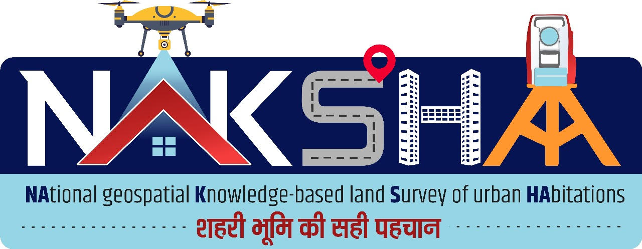
The Department of Land Resources (DoLR) and LBSNAA organized a national workshop for District Collectors on the NAKSHA programme. NAKSHA, or NAtional geospatial Knowledge-based land Survey of urban Habitations, aims to revolutionize urban land records.
Copyright infringement not intended
Picture Courtesy: PIB
The Department of Land Resources (DoLR) in collaboration with the Lal Bahadur Shastri National Academy of Administration (LBSNAA), organised a Workshop on the NAKSHA Programme for District Magistrates and Collectors.
It was launched in 2024 to digitize and update urban land records using advanced geospatial technology, creating accurate, and transparent databases to resolve issues arising from outdated records.
The Ministry of Rural Development's Department of Land Resources is the nodal agency for its implementation.
Three-Stage Survey Process:
Outdated Land Records
Most urban areas suffer from outdated or unorganized land records, leading to governance and taxation inefficiencies.=
High Volume of Land Disputes
Land and property disputes account for over 66% of civil litigation, largely due to the absence of digitized, tamper-proof land maps. (Source: PIB)
Revenue Losses for Urban Local Bodies (ULBs)
Poor land records lead to revenue loss for Urban Local Bodies (ULBs) due to inaccurate property tax assessment and collection.
The Comptroller and Auditor General (CAG) report showed that urban local bodies (ULBs) nationwide face challenges in financial management, generate a mere 32% of their revenue from internal sources.
Hindrance to Urban Planning
Reliable geospatial data is crucial for urban development, infrastructure, and smart cities; its absence causes project delays and increased costs.
Prevention of Fraud
Poor land documentation fuels fraud, corruption, and tax evasion, eroding public trust in urban land management.
Digital India Land Records Modernization Programme (DILRMP)
NAKSHA extends DILRMP's focus on rural land records to urban areas, working towards a unified national land record system ("One Nation, One Land Record").
PM Gati Shakti National Master Plan
By providing geospatial infrastructure and data, NAKSHA supports integrated infrastructure planning, leading to better project design and optimized resource allocation.
National Geospatial Policy (2022)
NAKSHA directly contributes to the policy's goal of harnessing the economic potential of geospatial data across various sectors.
National Data Governance Framework Policy (NDGFP)
As a data-intensive program, NAKSHA operates within the NDGFP's guidelines for data management, security, and sharing, ensuring privacy, trust, and ethical use of non-personal data.
NAKSHA provides the essential accurate and real-time land data needed for effective development and management of smart cities.
Robust Capacity Building
Invest in continuous training on geospatial tech, data management, and legal aspects for staff. Share best practices from states like Kerala, Maharashtra, and Madhya Pradesh.
Standardisation and Interoperability
Common data standards and protocols are essential for all urban land records. A seamless data exchange framework between NAKSHA, PM Gati Shakti, SVAMITVA, and other government platforms should be a priority.
Technological Upgradation
Regularly update the Web-GIS platform, integrating new AI and drone technology for better accuracy and efficiency.
Public Engagement and Grievance Redressal
Launch awareness campaigns for NAKSHA's benefits and encourage citizen participation in verifying draft land records. Establish efficient grievance redressal.
Legal and Administrative Reforms
Streamline land laws and administrative procedures to create a more efficient digital framework.
Source: PIB
|
PRACTICE QUESTION Q. Discuss the significance of NAKSHA Programme in addressing the challenges of urbanization in India. 250 words |
The Land Ceiling Acts of the 1960s and 70s aimed to cap family land ownership, with excess land redistributed by the government to landless and marginalized groups to reduce land concentration.
ULPIN (Bhu-Aadhar) is a 14-digit alphanumeric code generated from geographical coordinates, uniquely identifying each land parcel to ensure distinct land records and prevent fraud.
The Digital India Land Records Modernization Programme (DILRMP), launched in 2008 as the NLRMP and renamed in 2016, is a central sector scheme fully funded by the central government, aiming to modernize land record management and voluntarily link Aadhaar to land records.


© 2026 iasgyan. All right reserved