Description
Disclaimer: Copyright infringement not intended.
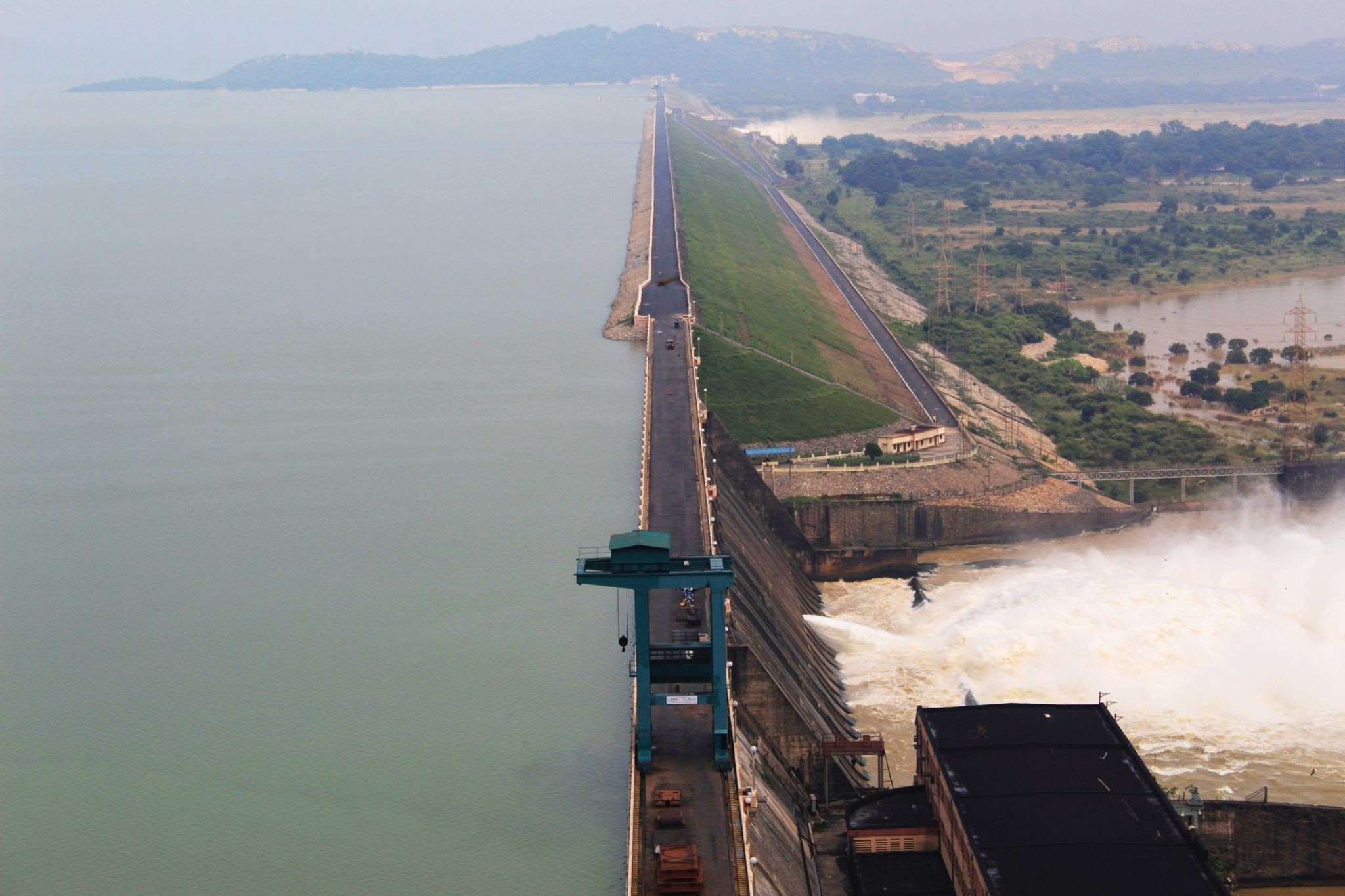
Details
Key Facts about Hirakud Dam
- Hirakud Dam is located around 15 kilometers from Sambalpur in the state of Odisha, across the Mahanadi River.
- It is the world's longest earthen dam, measuring around 16 miles and 26 kilometers in length.
- The dam creates the Hirakud Reservoir, also known as Hirakud Lake. It is Asia's largest man-made lake.
- The main dam has an overall length of 4.8 km (3.0 mi) spanning between two hills; the Laxmidungri on the left and the Chandili Dunguri on the right.
History behind this dam
- It is one of India's first multifunctional projects following independence.
- The building began in 1948 and was finished in 1953.
- It was created to control the flow of the Mahanadi River and manage the region's recurring flood problem.
- The dam was inaugurated in 1957 by then-Prime Minister Jawaharlal Nehru.

Structure of this dam
- The dam's most common building materials are granite, hard concrete, and soil.
- The main construction of Hirakud Dam is around 4.8 kilometers long, stretching from the Chandidungri hills on the right to the Lamdungri hills on the left.
- The catchment area is approximately 83400 square kilometers, and the dam is a concrete, masonry, and earthen structure.
Purpose
- The purpose of this project is to provide irrigation to 1,08,385 hectares of Rabi crops and 1,55,635 hectares of Kharif crops in Bolangir, Subarnapur, Bargarh, and Sambalpur.
- The installed power generation capacity at Hirakud dam is 359.8 MW.
- The water released by the powerhouse also irrigates about 436,000 hectares of land in the Mahanadi delta.
- The Hirakud Project also protects the delta area in Cuttack and Puri districts, which encompasses an area of 9500 square kilometers.
Cattle Island:
- Cattle Island is a small island located within the Hirakud Reservoir.
- It is home to a huge herd of wild cattle, who are said to be descendants of animals left behind by locals when the dam was built in the 1950s.
The Mahanadi River:
- It is one of India's major east-flowing peninsular rivers.
- The river gets its name from the Sihawa range of hills in Chhattisgarh's Dhamtari district.
- It flows southeasterly through Chhattisgarh and Odisha.
- The basin's catchment area includes large areas of Chhattisgarh and Odisha, as well as lesser portions of Jharkhand, Maharashtra, and Madhya Pradesh.
- It flows a total of 860 kilometers before reaching the Bay of Bengal.
- Seonath River, Jonk River, Hasdeo River, Mand River, Ib River, Ong River, and Telen River are the main tributaries of the Mahanadi.
Other Major Dams in India
|
List Of MajorList Of Major Dams in IndiaDams in India
|
State
|
River
|
|
Bhavani Sagar dam
|
Tamil Nadu
|
Bhavani
|
|
Tungabhadra Dam
|
Karnataka
|
Tungabhadra
|
|
Rihand Dam
|
Uttar Pradesh
|
Rihand
|
|
Maithon Dam
|
Jharkhand
|
Barakar
|
|
Koyna Dam
|
Maharashtra
|
Koyna
|
|
Bisalpur Dam
|
Rajasthan
|
Banas
|
|
Mettur Dam
|
Tamil Nadu
|
Kaveri
|
|
Krishnarajasagar Dam
|
Karnataka
|
Kaveri
|
|
Indira Sagar Dam
|
Madhya Pradesh
|
Narmada
|
|
Cheruthoni Dam
|
Kerala
|
Cheruthoni
|
|
Sardar Sarovar Dam
|
Gujarat
|
Narmada
|
|
Nagarjuna Sagar Dam
|
Telangana
|
Krishna
|
|
Hirakud dam
|
Odisha
|
Mahanadi
|
|
Bhakra Nangal Dam
|
Punjab-Himachal Pradesh Border
|
Sutlej
|
|
Tehri Dam
|
Uttarakhand
|
Bhagirathi
|

|
PRACTICE QUESTION
Dam infrastructure is important to primary and secondary sectors of Indian economy. Discuss
|


