Climate change is causing extreme floods in Northern India due to warmer atmospheres, intensifying rainfall events and cloudbursts. This crisis highlights the need for climate-resilient disaster management and balancing development with environmental sustainability.
Copyright infringement not intended
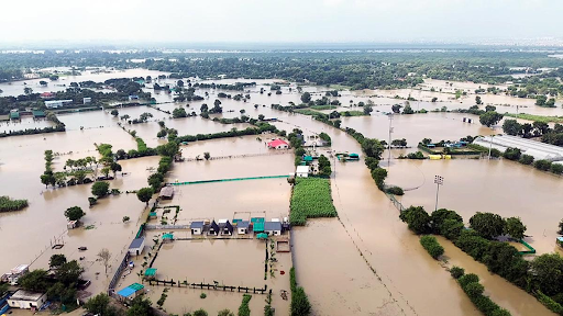
Picture Courtesy: THEHINDU
Context
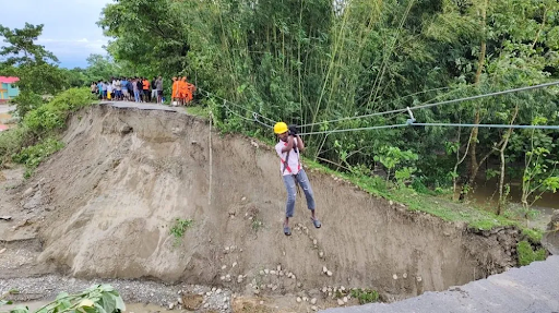
Heavy monsoon rains across North and Northwest India, causing widespread flooding in states like Uttar Pradesh, Punjab, Haryana, Himachal Pradesh, Uttarakhand, Delhi, and Jammu & Kashmir.
Scale of the Crisis
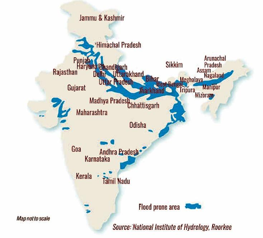
India is highly vulnerable to floods. Out of the total geographical area of 329 million hectares (mha), more than 40 mha is flood prone.
The Indo-Gangetic-Brahmaputra plains, carrying 60% of India’s river flow, are the epicenter of this crisis. In 2025 alone, floods killed over 240 people across North India since June, damaged 1.72 lakh hectares of crops in Punjab, and caused economic losses of approximately ₹5,702 crore in Uttarakhand.
Causes of Floods
Natural Causes Amplified by Climate Change
Extreme Rainfall: The monsoon (June–September) brings 75% of India’s annual rainfall, overwhelming rivers like the Yamuna, Sutlej, and Jhelum. Extreme rainfall events in Central India have tripled since 1950.
Western Disturbances: Erratic western disturbances, driven by a weakening Arctic jet stream, collide with monsoon systems, triggering heavy rains in North India.
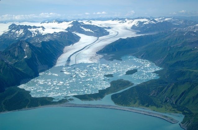
Glacial Melt: Himalayan glaciers, losing mass at 60–70% in some basins, increase river runoff in the Indus, Ganga, and Brahmaputra, heightening flood risks until at least 2050.
Oceanic Warming: The Indian Ocean has warmed by 1.0°C since 1951, faster than the global average of 0.7°C, intensifying monsoon rains and extreme Indian Ocean Dipole events.
Human-Induced Vulnerabilities
Unplanned Urbanization: Rapid urban growth in cities like Delhi and Noida has destroyed natural drainage systems. Encroachments on floodplains and wetlands, such as those along the Yamuna, exacerbate flooding.
Deforestation: Tree cover loss in the Himalayas, often due to road construction, reduces soil stability and increases runoff. A 10% rise in deforestation can increase flood risk by 28%.
Poor Drainage: Clogged drains and inadequate urban infrastructure in cities like Delhi and Gurugram lead to waterlogging even during moderate rains.
Dam Mismanagement: Only 7% of India’s dams have Emergency Action Plans, leading to sudden water releases that worsen downstream flooding, as seen in the 2018 Kerala floods.
Encroachment and Mining: Construction on riverbeds and unsustainable mining reduce river capacity, increasing flood risks in states like Uttarakhand.
|
Read all about: Flash Flood Management: Challenges And Way Forward |
Impacts of Floods
Human and Economic Losses: An average every year, 75 lakh hectares of land is affected, 1600 lives are lost and the damage caused to crops, houses and public utilities is Rs.1805 crores due to floods. (Source: National Disaster Management Authority)
Agriculture: Floods damaged 1.72 lakh hectares of crops in Punjab, threatening food security .
Displacement: In Punjab, 1948 villages across 22 districts have been impacted that have affected 3.84 lakh people.
Health Risks: Contaminated water sources increase risks of cholera and typhoid.
Ecosystem Damage: Soil erosion and sedimentation harm agricultural land and biodiversity, particularly in Kashmir’s apple orchards.
Positive Impacts: Floods recharge groundwater and enrich floodplains with nutrients, supporting agriculture like rice paddies.
Initiatives taken by for flood management
First National Flood Control Programme in 1954, included both structural measures (e.g., embankments, reservoirs) and non-structural measures (e.g., forecasting, flood plain zoning).
Flood Management and Border Areas Programme (FMBAP) provides financial assistance to states for flood management, anti-erosion, and drainage development.
The Union Budget 2024 allocated ₹11,500 crore in financial support for flood control and irrigation projects in flood-prone states like Bihar and Assam.
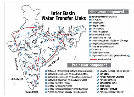
Interlinking of Rivers to transfer water from flood-prone, surplus river basins to water-deficit areas to mitigate both floods and droughts. The Ken-Betwa Link project is currently a key focus of this initiative.
Jal Shakti Abhiyan (JSA) emphasizes rainwater harvesting, groundwater recharge, and watershed management to help manage floodwaters.
The Amrit Sarovar Mission involves the development and rejuvenation of 75 water bodies in every district to help harvest rainwater and control floods.
The Central Water Commission (CWC) maintains a network of forecasting stations across 20 major river basins.
Dam Safety Act, 2021 provides a legal framework for the surveillance, inspection, operation, and maintenance of all large dams to prevent potential flood hazards from failures.
The National Disaster Management Authority (NDMA) sets the national policy and guidelines for disaster management, including floods.
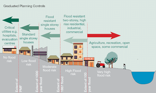
Flood Plain Zoning regulates development in flood-prone areas.
To address floods in transboundary rivers like the Ganga and Kosi, India engages in regular dialogues and coordination with neighboring countries such as Nepal and Bangladesh.
Challenges in flood management in india
Relief-centric approach: Focus on post-disaster relief and recovery rather than proactive, pre-disaster planning and mitigation.
Inter-state water disputes: Many of major river basins, like the Cauvery and Mahanadi, span across several states.
Delays in projects: Centrally-sponsored flood management programs face delays in project implementation due to issues with land acquisition.
Lack of dedicated central authority: No single national or state-level authority exclusively dealing with all aspects of flood management.
Unplanned urbanization: Rapid and unregulated development in urban centers has led to the encroachment of natural floodplains, wetlands, and other water bodies.
Inadequate drainage: Many urban areas have outdated and poorly maintained stormwater drainage systems.
Degrading structural measures: Embankments, a common flood control measure in states like Bihar and Assam, have proven ineffective. Silt accumulation in the riverbeds raises the water level higher than the surrounding land.
Climate change: Erratic and intense rainfall, rising sea levels, and glacier melt due to climate change are increasing the frequency and intensity of floods, creating new flood-prone areas that were not previously vulnerable.
Deforestation: Widespread deforestation reduces the soil's capacity to retain water, leading to increased surface runoff and a higher risk of river flooding.
Siltation: The high silt load carried by many Himalayan rivers, particularly the Brahmaputra and Ganga, raises riverbeds and reduces their carrying capacity, leading to more frequent flooding.
Way Forward
Strengthen Forecasting: Expand CWC’s flood forecasting network and integrate space technology for real-time monitoring.
Floodplain Zoning: Enforce NDMA’s zoning guidelines to restrict construction in high-risk areas.
Sustainable Infrastructure: Build flood-resilient drainage systems and embankments, ensuring regular maintenance.
Enhancing interstate cooperation: Establishing clear protocols for coordinated reservoir operations, data sharing, and joint project implementation.
River Interlinking: Accelerate projects like Ken-Betwa to divert excess water to drought-prone areas.
Environmental Restoration: Promote afforestation in the Himalayas and mangrove planting in coastal areas via the MISHTI initiative.
Climate-Resilient Agriculture: Develop flood-tolerant crop varieties and promote efficient irrigation.
Empower local communities: Encourage community-based early warning systems, training local volunteers, to bridge the "last-mile" connectivity gap and ensure warnings reach the most vulnerable populations in time.
Climate Mitigation: Reduce GHG emissions through renewable energy and carbon taxation to curb extreme weather events
Conclusion
Floods in North India are no longer just natural disasters but a stark reflection of climate change and human failures. With over 40 million hectares at risk and annual losses mounting, India must act swiftly. A blend of advanced forecasting, sustainable infrastructure, and climate-conscious policies is critical to building resilience.
Source: THEHINDU
|
PRACTICE QUESTION Q. The recent monsoon flooding in Northern India is a classic case of climate change amplifying natural hazards.. Critically Analyze. 250 words |
Climate change is making the monsoon more erratic, leading to longer dry spells followed by concentrated, extreme rainfall events (cloudbursts), which overwhelm drainage systems and cause sudden, severe floods.
Floodplain zoning is a non-structural flood management measure that aims to restrict unplanned development in flood-prone areas to mitigate the risk of damage and loss of life.
National Disaster Management Authority (NDMA) serves as the apex body for flood management and disaster preparedness, working with state and district-level authorities to respond to flood situations.


© 2026 iasgyan. All right reserved