Description
Disclaimer: Copyright infringement not intended.
Context
The issue of floods in the Punjab region of India and the importance of flood plain zoning as a strategy to manage and mitigate flood impacts.
Details
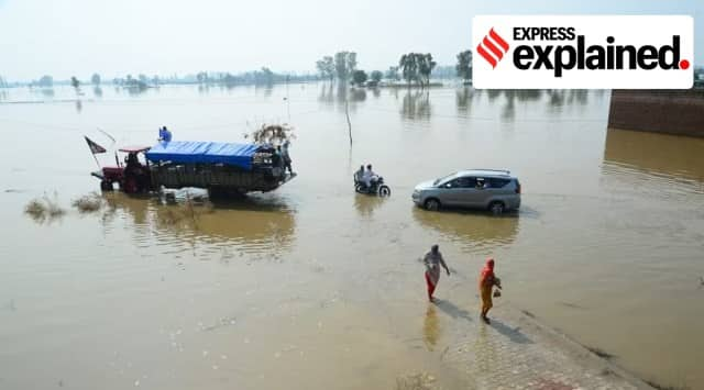
- The Punjab region has been grappling with prolonged floods, disproportionately affecting villages along rivers Sutlej, Beas, Ravi, and Ghaggar.
- Villages located in these sensitive flood plains experience severe damage during flood events.
Importance of FloodPlains
- Flood plains naturally expand and contract with river flow variations.
- A flood plain is an area adjacent to a river that gets flooded during river swells.
- Well-maintained flood plains act as natural defenses against inland flooding.
- They also play a role in groundwater recharge and maintaining the water table.
Need for Identification and Zoning
- Identifying flood plains is vital for effective flood management.
- Topographical features, including oxbow lakes, help experts identify flood plains.
- Flood plain zoning regulates land use to minimize flood damage during actual flood events.
Zoning Guidelines and Regulations
- National Disaster Management Authority guidelines prescribe zoning rules.
- Critical installations like defense installations, industries, hospitals, etc., should be situated above flood levels corresponding to a 100-year frequency.
- The National Green Tribunal mandates a no-construction zone of 500 m from a river's central lining.
Punjab's Situation
- Punjab lacks effective flood plain zoning despite NGT's directives.
- Flood plain encroachments continue due to lack of proper regulations.
- Villages along Sutlej, Beas, Ravi, and Ghaggar rivers remain at perennial risk due to encroachments.
Challenges and Risks
- Encroachments and mismanagement lead to non-suitable construction and concretization.
- Non-suitable constructions exacerbate flood impacts, pushing floods further inland.
- Concretization prolongs the subsiding of floodwaters and affects flood plains' health.
Impact on People and Environment
- The absence of zoning poses risks to people, property, and floodplains.
- Floods damage soil fertility and quality, affecting the overall health of flood plains.
- Multiple districts along the rivers in Punjab are at risk due to the absence of zoning.
Nationwide Issue
- Flood plain zoning is a challenge across the country.
- Only four states, including Manipur, erstwhile Jammu & Kashmir, Rajasthan, and Uttarakhand, have adopted zoning in principle.
- Implementation of zoning regulations has been inadequate even in these states.
Advocacy and Activism
- Environmental activists and NGOs in Punjab demand flood plain zoning.
- However, their efforts have not yielded significant results so far.
About Zoning of Flood Plains
- Zoning of flood plains involves designating areas along rivers and water bodies based on flood susceptibility.
- These designated zones come with regulations to guide land use and development activities for flood risk mitigation.
- The primary aim is to minimize flood-induced damage and ensure safety for people and property in flood-prone regions.
Zoning Process
- Flood plain area is divided into distinct zones, each with specific restrictions and permissible uses.
- Zone demarcation is based on flood likelihood and severity assessments.
- Regulations within zones determine allowable construction types, land uses, and elevation requirements.
Hierarchical Zoning Categories
- High Hazard Zone:
- Located closest to water bodies.
- Prone to frequent and severe flooding.
- Often restricts or prohibits construction to safeguard lives and property.
- Moderate Hazard Zone:
- Experiences less frequent and severe flooding.
- Limited construction might be allowed with elevation and design stipulations.
- Low Hazard Zone:
- Lower risk of flooding.
- Development activities permitted under specific safety-focused guidelines.
Addressing Setbacks
- Regulations may define setback distances from water bodies.
- Setbacks determine how far structures should be from water's edge to reduce flood impact.
- These guidelines consider flood frequencies, historical records, and community vulnerabilities.
Objective of Flood Plain Zoning
- Striking a balance between human development and environmental protection.
- Ensures construction and land use align with flood risk considerations.
- Aims to minimize property damage, loss of life, and economic consequences of floods.
Benefits and Implications
- Mitigates flood-induced damage in flood-prone regions.
- Enhances safety for inhabitants and property.
- Supports economic resilience by reducing flood-related losses.
Guided by Scientific Insights
- Zoning regulations based on scientific assessments.
- Utilizes flood frequency data, historical records, and community vulnerabilities.
- Ensures informed decisions to manage flood risks effectively.
Safeguarding Natural Functions
- Flood plain zoning preserves natural floodplain functions.
- Balances development goals with the maintenance of ecological systems.
|
PRACTICE QUESTION
Q) Discuss the concept and significance of flood plain zoning in the context of flood risk management and sustainable development. (150 words)
|
https://indianexpress.com/article/explained/why-zoning-of-flood-plains-is-important-8913109/


