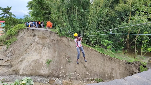
The Darjeeling disaster, caused by extreme rainfall, revealed the Eastern Himalayas’ vulnerability. Landslides and floods severed key routes, isolating Sikkim. Unsustainable development, weak governance, and poor disaster preparedness demand urgent mountain regulation and advanced early warning systems for future resilience.
Copyright infringement not intended
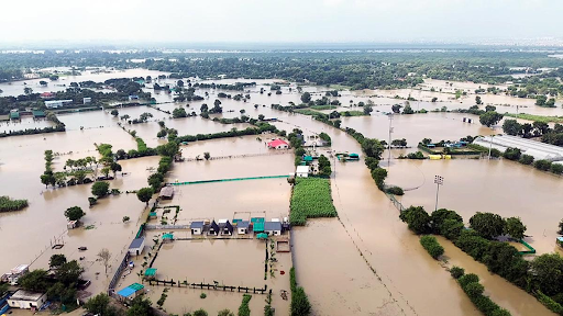
Picture Courtesy: INDIANEXPRESS
Severe rainfall-triggered landslides in Darjeeling and nearby areas have caused massive destruction, killing 24 people and isolating thousands by damaging vital infrastructure.
|
Read all about: DISASTER MANAGEMENT l NATIONAL DISASTER MANAGEMENT AUTHORITY (NDMA) |
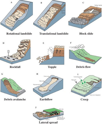
A landslide is the movement of a large mass of rock, earth, or debris down a slope under the influence of gravity. This movement can be rapid or gradual and is triggered by factors like heavy rainfall, earthquakes, volcanic eruptions, and erosion at the base of a slope.
Landslides are a type of mass wasting and include various forms of downslope movement, including falls, slides, spreads, and flows.
Natural Causes
Intense Rainfall: Heavy or prolonged rainfall soaks the soil, increasing its weight and reducing the friction that holds the slope together.
Earthquakes: Himalayas are a tectonically active region. Seismic tremors shake the ground, destabilizing slopes and triggering landslides.
Slope Gradient: Steeper slopes are naturally more vulnerable to the pull of gravity and, therefore, more likely to experience landslides.
Geological Weakness: Himalayan region is composed of young, fragile sedimentary rocks, making it naturally more prone to landslides than the older, more stable crystalline rocks of the Western Ghats.
River Erosion: Rivers can erode the base or "toe" of a slope, making it unstable and prone to collapse.
Human-Induced Causes (Anthropogenic Factors)
Deforestation: Roots of trees and vegetation act as natural binders for the soil. Removing this cover for agriculture or construction exposes the soil to erosion and increases instability.
Unscientific Construction: Construction of roads, buildings, and dams involves cutting into hillsides. This slope-cutting disrupts the natural angle and stability of the terrain, making it vulnerable to collapse.
Mining and Quarrying: These activities remove large amounts of rock and soil, weakening the geological structure of the area.
Changes in Land Use: Shifting from forests to agriculture or settlements on sloped land increases the load and alters water drainage patterns, raising the risk of landslides.
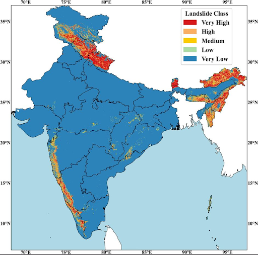
According to the Geological Survey of India (GSI), about 12.6% of India's land area is prone to landslides. The major vulnerable regions are:
Loss of Life and Property: The most direct impact is the loss of human life and the destruction of homes and property.
Infrastructure Damage: Landslides destroy critical infrastructure like roads, bridges, railway lines, and communication networks, leading to the isolation of communities and hampering relief efforts.
Economic Disruption: Damage to infrastructure, agriculture (burial of fertile land), and the disruption of tourism lead to economic losses for the affected regions.
Environmental Damage: Landslides cause soil erosion, loss of forest cover, and block rivers, forming "landslide dams." These dams pose a threat of catastrophic downstream flooding if they suddenly breach.
India has a robust, multi-tiered disaster management framework, established under the Disaster Management Act, 2005.
National Disaster Management Authority (NDMA): This is the apex body, chaired by the Prime Minister, responsible for laying down policies, plans, and guidelines for disaster management.
State Disaster Management Authority (SDMA): Headed by the respective Chief Ministers, the SDMA is responsible for implementing the national plan at the state level.
District Disaster Management Authority (DDMA): Chaired by the District Collector, the DDMA acts as the planning and coordinating body for disaster management at the district level.
National Disaster Response Force (NDRF): This is a specialized force trained for responding to natural and man-made disasters, including search and rescue operations in landslide-affected areas.
For landslides: The Geological Survey of India (GSI) is the nodal agency responsible for research, monitoring, and developing early warning systems.
Hazard Zonation and Land-Use Planning
Structural Measures
Non-Structural Measures
Strengthening Governance: Ensure strict enforcement of land-use and environmental regulations without political interference.
Investing in Science and Technology: Scale up the use of technology for accurate landslide forecasting and real-time early warning systems.
Integrate Science into Policy: Landslide hazard maps and scientific assessments must be made a mandatory part of all development and urban planning processes in hilly regions.
Empowering Local Communities: Local communities are the first responders in any disaster. Investing in community-based disaster preparedness through training programs like 'Aapda Mitra' can save countless lives.
|
What can India learn from other countries? Japan: Known for its advanced technological approach, Japan uses a dense network of sensors (sabo dams equipped with sensors, extensometers) to monitor slope movement in real-time, providing highly accurate early warnings. Switzerland: Switzerland excels in comprehensive land-use planning and hazard mapping. Development in high-risk zones is strictly prohibited by law, and this is rigorously enforced. Hong Kong: Hong Kong has a world-class slope safety system that combines engineering standards for man-made slopes with a robust public education and community awareness program. |
Landslides are natural, but their growing destruction originates from human neglect. Unregulated mountain development worsens risks. Adopting scientific planning, strict regulation, and community-driven resilience—guided by global best practices—can help India protect its fragile ecosystems and ensure safer, sustainable mountain livelihoods.
Source: INDIAN EXPRESS
|
PRACTICE QUESTION Q. Differentiate between the causes and frequency of landslides in the Himalayan region and the Western Ghats. 150 words |
Carrying capacity is the maximum population and infrastructure a region can sustainably support; exceeding it through unplanned urbanization and heavy construction destabilizes slopes and infrastructure.
A landslide is a type of mass wasting, which describes any movement of rock, debris, or soil down a slope due to gravity. They can range from very slow to extremely rapid events.
Landslides occur most frequently in mountainous or hilly regions with unstable slopes. However, they can also happen in coastal areas, river valleys, and areas affected by wildfires, which can destroy the vegetation that holds soil in place.


© 2026 iasgyan. All right reserved