Source: UNIVERSITY OF OXFORD
Disclaimer: Copyright infringement not intended.
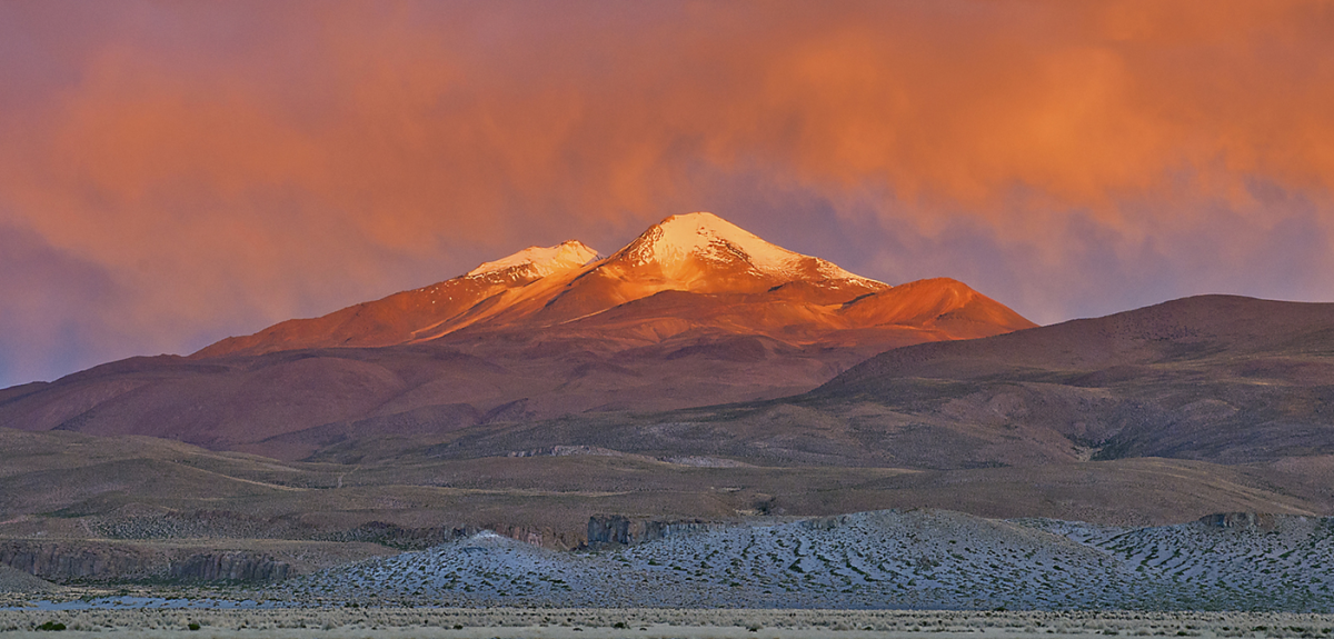
Scientists from China, UK & U.S. used advanced seismic tomography & petrological modeling to unravel non-eruptive unrest of Bolivia Uturuncu zombie volcano revealing low eruption risk due to subsurface fluid & gas movement.
|
Feature |
Details |
|
Location |
Southwestern Bolivia within Andes Mountains. |
|
Volcanic Type |
Stratovolcano, dominated by dacitic lava domes & flows. |
|
Elevation |
6,008 meters (19,711 feet) above sea level making it tallest mountain in southern part of Bolivia. |
|
Last Eruption |
Last erupted approximately 250,000 years ago. |
|
Seismic Activity |
Seismically active with frequent earthquake events & ongoing deformation. |
|
Area of Influence |
Located at center of a 70 km diameter uplifted region showing active signs of volcanic unrest such as surface deformation & gas emissions. |
|
Magma Reservoir |
Sits above Altiplano-Puna Magma Body (APMB), a massive & deep underground reservoir stretching across southern Bolivia, northern Chile & northern Argentina. |
|
Unrest Characteristics |
Known as a zombie volcano due to continued but non-eruptive activity such as movement of liquid & gases beneath crater. |
|
Cause of Unrest |
The unrest is primarily caused by migration of magma, fluid & gas beneath surface leading to uplift of land at volcano center & subsidence around it. |
|
Risk of Eruption |
Low likelihood of imminent eruption despite ongoing seismic activity & deformation. |
|
Scientific Research |
Recent studies combined seismic tomography & rock composition analysis to map out volcanic plumbing system which revealed fluid & gas dynamics below surface. |
|
Hydrothermal System |
Active hydrothermal system connecting magma body with surface contributing to movement of fluids & gases. |
|
Significance of Study |
The study of Uturuncu unrest is crucial for understanding similar zombie volcanoes improving early warning systems for volcanic hazards & refining volcanic hazard modeling. |
|
Tourism & Cultural Significance |
The volcano is part of Altiplano region which holds significant cultural & geological importance for local communities & offers scenic vistas for researchers & tourists. |
|
Feature |
Details |
|
Definition |
A technique used to image interior of Earth using seismic waves generated by earthquakes or artificial sources. |
|
Principle |
Seismic waves travel at different speeds through different materials. The variation in speed of these waves helps create a detailed image of subsurface structures. |
|
Types of Seismic Waves |
P-waves (primary or pressure waves) faster & can travel through solids, liquids & gases. |
|
Uses in Volcanology |
Imaging of magma chambers & reservoirs. |
|
Application at Uturuncu |
Used to identify migration paths of fluids & gases beneath volcano. |
|
Advantages |
Provides 3D imaging of interior. |
|
Challenges |
Requires extensive seismic data collection. |
|
Feature |
Details |
|
Location |
Extends across Altiplano (southern Bolivia), Puna Plateau (northwestern Argentina) & northern Chile. |
|
Size |
Covers a vast region of approximately 500,000 square kilometers. |
|
Geological Significance |
Home to world largest known magma body beneath Earth's crust known as Altiplano-Puna Magma Body (APMB). |
|
Active Volcanic Centers |
Includes Uturuncu, Llullaillaco, Mount Parinacota & Mount Ojos del Salado ( world’s highest active volcano). |
|
Age |
The volcanic region has been active for millions of years, with current volcanic activity occurring within last 200,000 years. |
|
Volcanic Activity |
Frequent eruptions in past. |
|
Magma Composition |
Primarily dacitic & andesitic magmas often associated with explosive eruptions. |
|
Tectonic Setting |
Situated within subduction zone where Nazca Plate is being subducted beneath South American Plate leading to volcanic activity in region. |
|
Environmental Significance |
Vital for local ecosystems contributing to mineral deposits. |
|
Human Impact |
The region is sparsely populated but volcanic hazards can affect local populations. |
|
Feature |
Details |
|
Definition |
A hydrothermal system involves circulation of hot fluids such as water & gas through subsurface volcanic structures often resulting in surface manifestations like hot springs & fumaroles. |
|
Components |
Magma chamber Supplies heat to hydrothermal system. |
|
Role in Volcanic Systems |
Hydrothermal systems transfer heat & gases from deeper layers of Earth to surface influencing volcanic activity, gas emissions & geothermal energy production. |
|
Hydrothermal Activity at Uturuncu |
Evidence of active hydrothermal systems connecting surface & Altiplano-Puna Magma Body (APMB) beneath. |
|
Gas Emissions |
The release of gases such as sulfur dioxide, carbon dioxide & water vapor is a common feature of hydrothermal system. |
|
Deformation Patterns |
The sombrero pattern (central uplift & surrounding subsidence) observed on Uturuncu is caused by ongoing migration of geothermal fluids beneath surface. |
|
Risk Assessment |
Though Uturuncu remains a zombie volcano hydrothermal system is active leading to ongoing seismic activity. |
|
Temperature & Fluid Migration |
Geothermal fluids migrate upward contributing to surface deformation & creating underground reservoirs of gas & liquid. |
|
Impact on Local Communities |
Although there is no immediate eruption risk hydrothermal system activity could influence landscape potentially affecting agriculture, tourism & local infrastructure. |
For more such articles, please refer to IAS GYAN
Sources: MSN
|
PRACTICE QUESTION Q. The hydrothermal system at Uturuncu has been identified as a key factor in its continued unrest. Examine interaction between magma, fluids & gases in such volcanic systems & their potential impact on local populations. |


© 2026 iasgyan. All right reserved


