Disclaimer: Copyright infringement not intended.
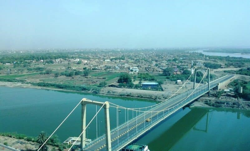
A recent report outlines strategic occupation of Tuti Island during Sudan conflict, humanitarian catastrophe faced by its residents & broader implications of prolonged urban warfare in Sudan capital region.
|
Aspect |
Details |
|
Location |
Situated at confluence of Blue & White Nile rivers in Khartoum Sudan |
|
Geographic Coordinates |
Approx. 15.610°N, 32.510°E |
|
Size |
8 square kilometres (approx. 3 sq. miles) |
|
Shape & Accessibility |
Crescent shaped island; accessible via Tuti Suspension Bridge (only vehicular route) |
|
Administrative Affiliation |
Part of Khartoum State |
|
Historical Significance |
One of Khartoum oldest continuous settlements |
|
Cultural Identity |
Home to Mahas Nubian community since 15th century |
|
Nickname |
Khartoum Garden known for lush fields of beans, arugula, fruit trees & vegetables |
|
Primary Livelihoods |
Farming, fishing, traditional irrigation |
|
Environmental Assets |
Fertile alluvial soils from Nile floods |
|
Water Access |
Nile & traditional wells |
|
Conflict Impact (2023–2025 Sudan War) |
Captured by RSF early in war (April 15, 2023) |
|
Demographic Impact |
Pre-war population ~15,000+ (est.) |
|
UN War Estimates (Khartoum) |
13 million displaced across Sudan |
|
Climate Change Vulnerabilities |
Disruption of Nile flood cycle |
|
Heritage Project – HEART |
Heritage Empowered Action for Risk in Tuti |
|
Current Status (2025) |
Bridge reopened |
|
Strategic Importance |
Symbol of civilian resistance, indigenous heritage & Nile-based livelihood |
|
Aspect |
Details |
|
Conflict Start Date |
April 15, 2023 |
|
Main Belligerents |
Sudanese Armed Forces (SAF) under Gen. Abdel Fattah al-Burhan |
|
Type of Conflict |
Power struggle post coup; devolved into full scale civil war |
|
Primary War Zones |
Greater Khartoum (Khartoum, Omdurman, Bahri) |
|
Casualties |
70,000+ killed (estimated, underreported) |
|
Displacement |
13 million displaced (internally & externally) incl. 3.5M in Khartoum |
|
Food Insecurity |
18 million affected; 100,000+ at famine-levels in Khartoum alone (UN) |
|
Key Human Rights Violations |
Systematic looting |
|
International Response |
Limited humanitarian access |
|
Phase |
Key Events |
|
Initial Assault (April–June 2023) |
RSF quickly seized central Khartoum including Tuti Island |
|
Urban Combat Phase (Late 2023) |
Street to street fighting in Bahri & Omdurman |
|
Siege Period (2024) |
Khartoum largely under RSF dominance |
|
Army Counteroffensive (2025) |
March 22 Sudanese Army regains Tuti Bridge |
|
Island Name |
Location |
Area |
River |
Key Features |
Strategic or Cultural Importance |
|
Tuti Island |
Khartoum (Nile confluence) |
~8 sq. km |
Blue & White Nile |
Fertile, urban adjacent, strategic access point |
High – control over Khartoum |
|
Meroë Island (near Kabushiya) |
Northern State |
~1–2 sq. km |
Nile |
Ancient pyramids of Meroitic civilization |
UNESCO World Heritage Site |
|
Argo Island |
Northern Sudan (Dongola) |
~6–8 sq. km |
Nile |
Agricultural island, Nubian culture |
Historical seat of Nubian kingdoms |
|
Sai Island |
Upper Nubia |
~12 sq. km |
Nile |
Archaeological site, Bronze Age & Ottoman ruins |
Cross-cultural historical significance |
|
Mograt Island |
Near Abu Hamed, Nile |
~70 sq. km |
Nile |
Largest island on Sudanese Nile |
Tribal habitation (Manasir people), farming |
|
Karma Island |
Upper Nubia |
~2–3 sq. km |
Nile |
Ancient Kushite capital |
Archaeological significance |
|
Aspect |
Details |
|
Length in Sudan |
~3,000 km of total 6,650 km (longest river in world) |
|
Source Rivers |
White Nile Originates from Lake Victoria (Uganda) |
|
Confluence |
Khartoum where Blue Nile (from southeast) meets White Nile (from south) |
|
Exit from Sudan |
Enters Egypt at city of Wadi Halfa (Northern State) |
|
Basin Coverage in Sudan |
~2 million sq. km of Nile Basin area including major Sudanese cities |
|
Tributaries in Sudan |
Atbara River (joins near Berber) |
|
Major Cities Along Nile in Sudan |
Khartoum (confluence point) |
|
Geographical Zones |
Upper Nile South Sudan border to Khartoum |
|
Main Uses |
Agriculture (irrigation-based, Gezira Scheme) |
|
Hydrological Features |
Seasonal flood cycle (July to September) |
|
Climate Impact |
Highly sensitive to ENSO & Indian Ocean Dipole (IOD) events |
|
Irrigation Projects |
Gezira Irrigation Scheme (one of Africa's largest, ~880,000 ha) |
|
Major Dams in Sudan |
Roseires Dam (Blue Nile, 1966/2013 expansion) |
|
Environmental Concerns |
Desertification |
|
Geopolitical Tensions |
Nile Water Rights Disputes (with Egypt & Ethiopia) |
|
Recent Conflict Impact |
Damage to pump stations & water infrastructure in Khartoum |
|
Biodiversity |
Nile crocodiles, hippos (south) |
|
Cultural-Historical Significance |
Lifeline of ancient Kushite & Nubian civilizations |
For more such articles, please refer to IAS GYAN
Sources:
|
PRACTICE QUESTION Q. Tuti Island exemplifies human environment relationship in riverine civilizations. Elaborate. |


© 2026 iasgyan. All right reserved


