Source: WORLDATLAS
Disclaimer: Copyright infringement not intended.
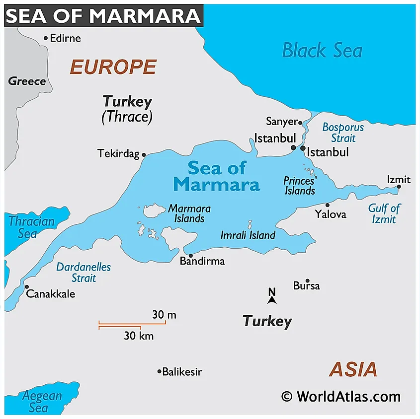
A magnitude 6.2 earthquake shook Istanbul with its epicenter in Sea of Marmara highlighting Turkey seismic vulnerability & ongoing urban reconstruction efforts to mitigate future disasters.
|
Feature |
Details |
|
Type |
Inland Sea |
|
Location |
Entirely within Republic of Turkey (transcontinental Europe & Asia) |
|
Area |
Approximately 11,350 sq.km |
|
Length |
About 280 km |
|
Maximum Width |
Around 80 km |
|
Average Depth |
About 494 meters |
|
Maximum Depth |
Approximately 1,370 meters (deepest point in central trench) |
|
Connecting Straits |
Connected to Black Sea via Bosphorus Strait (northeast) |
|
Geological Importance |
Lies directly on North Anatolian Fault a major strike-slip fault line responsible for severe seismic activity |
|
Seismic Activity |
Highly earthquake-prone; historical quakes include 1509, 1766, 1999 İzmit (magnitude 7.4) & 2025 Istanbul quake (magnitude 6.2) |
|
Tectonic Setting |
Transitional boundary between Anatolian Plate & Eurasian Plate |
|
Climate |
Humid Subtropical Climate (Cfa, Köppen classification) |
|
Salinity Characteristics |
Surface Freshwater dominated from Black Sea inflow |
|
Ecological Significance |
Important for fish migration routes especially anchovy & mackerel; diverse marine ecosystems but facing threats from pollution & eutrophication |
|
Major Islands |
Marmara Island (largest, rich in marble) |
|
Major Coastal Cities |
Istanbul (northeastern shore) |
|
Historical Significance |
Major maritime route during Roman, Byzantine & Ottoman times |
|
Economic Activities |
Heavy shipping & port activities (especially at Istanbul & İzmit) |
|
Environmental Threats |
Marine mucilage crisis (2021) due to eutrophication & pollution |
|
Strategic Importance |
Forms part of only maritime passage between Black Sea & Mediterranean (critical for global naval & shipping movements) |
|
Natural Hazards |
High tsunami risk due to fault movements beneath sea |
|
Unique Feature |
One of few inland seas that entirely separates a single country's European & Asian parts |
The Sea of Marmara acts as a buffer zone for temperature & salinity changes between Black Sea & Aegean/Mediterranean.
Imrali Island houses Turkey high-security prison (where Kurdish leader Abdullah Öcalan is imprisoned).
Prince Islands are car-free; transport mainly by bicycles, electric buggies & horse-drawn carriages historically.
The Sea of Marmara is vital for Istanbul's economy: through trade, fishing & tourism.
|
Feature |
Details |
|
Major Tectonic Plates |
1. Anatolian Plate (microplate) |
|
Minor/Associated Plates |
Aegean Sea Plate (small plate near Greece) |
|
Movement of Anatolian Plate |
Westward slip (~21–25 mm/year) |
|
Plate Boundary Types |
Convergent Boundaries (Arabian Plate colliding with Eurasian Plate) |
|
Major Fault Systems |
North Anatolian Fault (NAF) A major east-west strike-slip fault extending ~1,500 km across northern Turkey. |
|
North Anatolian Fault Details |
Runs from eastern Turkey (Karlıova Triple Junction) to Marmara Sea & northern Aegean |
|
East Anatolian Fault Details |
Left-lateral strike-slip fault |
|
African Plate Subduction |
South of Turkey |
|
Seismic Hotspots |
Istanbul (near NAF) |
|
Tectonic Evolution |
Result of collision between African-Arabian Plates & Eurasian Plate since late Mesozoic-Cenozoic periods |
|
Triple Junctions |
Karlıova Triple Junction (where North Anatolian, East Anatolian & Bitlis-Zagros faults meet) |
|
Key Earthquakes in History |
1509 Constantinople earthquake ("Little Doomsday") |
|
Earthquake Preparedness |
Massive urban renewal projects post-1999 İzmit quake |
|
Potential Future Risk Zones |
Marmara Sea (near Istanbul) - highest risk |
|
Special Features |
Turkey is one of most seismically active regions in world outside of major subduction zones. |
For more such articles, please visit IAS GYAN
Sources:
|
PRACTICE QUESTION Q. Discuss tectonic setting of Turkey with reference to Anatolian Plate. How have major fault systems like North Anatolian Fault & East Anatolian Fault contributed to Turkey high seismic risk? Evaluate measures taken by Turkey to mitigate earthquake impacts. |


© 2026 iasgyan. All right reserved


