Description
Disclaimer: Copyright infringement not intended.
Context
- India is pushing tech giants to make smartphones compatible with its home-grown navigation system- NavIC within months. This is worrying Samsung, Xiaomi and Apple who fear elevated costs and disruptions as the move requires hardware changes.
NaviC
- NavIC (Navigation with Indian Constellation) is an autonomous regional satellite navigation system established and maintained by ISRO.
Coverage
- It covers India and a region extending up to 1,500 km beyond Indian mainland (primary coverage area) with plans of extension.
- An extended service area lies between the primary service area and a rectangle area enclosed by the 30th parallel south to the 50th parallel north and the 30th meridian east to the 130th meridian east.
Satellites
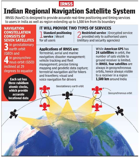
- The system currently consists of a constellation of eight satellites.
- Three satellites in constellation are located in geostationary orbit (GEO) and four in inclined geosynchronous orbit (IGSO).
Accuracy
- The system is intended to provide an absolute position accuracy of better than 10 metres throughout Indian landmass and better than 20 metres in the Indian Ocean.
- In short, it provides position accuracy better than 20 m and timing accuracy better than 50 nanoseconds(20).
Applications
- NavIC will provide two levels of service, the "standard positioning service", which will be open for civilian use, and a "restricted service" (an encrypted one) for authorised users (including the military).
- NavIC based applications are being used in various civilian sectors, including, transport, map applications, and timekeeping.
- NavIC based trackers are compulsory on commercial vehicles in India.
- Today major mobile chipset manufacturers like Qualcomm, MediaTek and Broadcom already support NavIC across various chipset platforms.
- A few mobile handsets have been released which can be enabled to receive NavlC.
Examples Redmi Note 9 series from Xiaomi, the Realme 6 series, the OnePlus Nord, etc.
- NavlC is an indigenous positioning system that is under Indian control.
- There is no risk of the service being withdrawn or denied in a given situation.

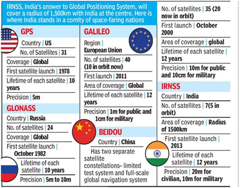
GPS VS NAVIC
- The GPS, has a position accuracy of 20–30 m.
- Unlike GPS which is dependent only on L-band, NavIC has dual frequency (S and L band frequencies).
- When low frequency signal travels through atmosphere, its velocity changes due to atmospheric disturbances.
- US banks on atmospheric model to assess frequency error and it has to update this model from time to time to assess the exact error.
- In India's case, the actual delay is assessed by measuring the difference in delay of dual frequency (S and L bands).
- Therefore, NavIC is not dependent on any model to find the frequency error and is more accurate than GPS.
- The main difference is the serviceable area covered by these systems. GPS caters to users across the globe and its satellites circle the earth twice a day, while NavIC is currently for use in India and adjacent areas.
- Like GPS, there are three more navigation systems that have global coverage - Galileo from the European Union, Russia-owned GLONASS and China's Beidou. QZSS, operated by Japan, is another regional navigation system covering Asia-Oceania region, with a focus on Japan.
About Frequency Bands
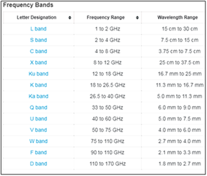
L Band
- The L band is the Institute of Electrical and Electronics Engineers (IEEE) designation for the range of frequencies in the radio spectrum from 1 to 2 gigahertz (GHz).
Applications
- Mobile service
- Satellite navigation
- Telecommunications use
- Aircraft surveillance
- Amateur radio
- Digital audio, Video, multimedia broadcasting
- Astronomy
Advantages of L Band Frequency over other frequency bands:
- This frequecy band faces less interference from heavy rain fading
- The low frequency range makes it easier to design and source components
- The components for this band are less expensive than those for higher frequency bands
S band
- The S band is a designation by the Institute of Electrical and Electronics Engineers (IEEE) for a part of the microwave band of the electromagnetic spectrum covering frequencies from 2 to 4 gigahertz (GHz).
Applications
- The S band is used by airport surveillance radar for air traffic control, weather radar, surface ship radar, and some communications satellites,especially those used by NASA to communicate with the Space Shuttle and the International Space Station.
- The largest use of this band is by WiFi networks.
- The S band can also be used for issuing distress signals in accident situations and for delivering real-time data and status for traffic and weather conditions.
- In some countries, S band is used for Direct-to-Home satellite television.
- IndoStar-1 was the world's first commercial communications satellite to use S-band frequencies for broadcast.
Significance of NaVIC
- Currently, NavIC's use is limited. It is being used in public vehicle tracking in India, for providing emergency warning alerts to fishermen venturing into the deep sea where there is no terrestrial network connectivity, and for tracking and providing information related to natural disasters. Enabling it in smartphones is the next step India is pushing for. NavIC is conceived with the aim of removing dependence on foreign satellite systems for navigation service requirements, particularly for "strategic sectors."
https://www.thehindu.com/sci-tech/technology/india-push-home-grown-navigation-system-jolts-smartphone-giants-apple-xiaomi-navic-samsung/article65937529.ece