Mullaperiyar Dam is located in the Idukki district of Kerala, South India. It is situated beside the Periyar River. The dam's primary objective was to transmit water from the Periyar River to the desert rain shadow districts of Madras Presidency (now Tamil Nadu) for irrigation via a tunnel.
Copyright infringement not intended
PC: Scroll.in
The Supreme Court has asked Tamil Nadu and Kerala to resolve contentious issues with the Mullaperiyar dam through expert assistance.
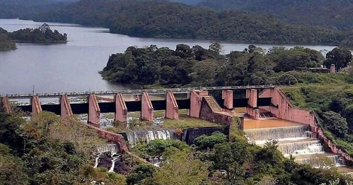
The Mullaperiyar Dam is located in the Cardamom Hills of the Western Ghats near Kumily in the Idukki district, on the Kerala-Tamil Nadu border.

Copyright infringement not intended
PC: Prokerala
The dam, built in 1895 with limestone and surkhi, diverts water from the Periyar River in Kerala to Tamil Nadu's Vaigai basin for irrigation and drinking water.
|
Name of the Dam |
Mullaperiyar Dam |
|
Type |
Masonry gravity dam |
|
River |
Built at the confluence of the Mullayar and Periyar rivers |
|
Location |
Thekkady, Idukki district, Kerala |
|
Altitude |
881 meters above sea level |
|
Mountain Range |
Western Ghats |
|
Construction Period |
Began in 1887, completed in 1895 |
|
Constructed By |
British Corps of Royal Engineers under Colonel John Pennycuick |
|
Materials Used |
Limestone and “Surkhi” (burnt brick powder + sugar + calcium oxide) |
|
Height |
53.6 meters (176 feet) |
|
Length |
365.7 meters (1,200 feet) |
|
Storage Capacity |
443 million cubic meters (11.5 billion cubic feet) |
|
Reservoir Area |
8.5 square kilometers (artificial lake created) |
|
Surroundings |
Periyar National Park – a rich biodiversity hotspot |
|
Purpose |
Transfer water to Vaigai River basin in Tamil Nadu for irrigation and power generation |
|
Operational Control |
Managed by Tamil Nadu, although the dam is located in Kerala |
|
Lease Agreement |
999-year lease made during British rule giving operational rights to Tamil Nadu |
Source: The Hindu
Practice QuestionQ. With reference to the Mullaperiyar Dam, consider the following statements:
Which of the statements given above is/are correct? A. 1 and 2 only Correct Answer: B. 2 and 3 only Explanation:
|


© 2026 iasgyan. All right reserved


