Disclaimer: Copyright infringement not intended.
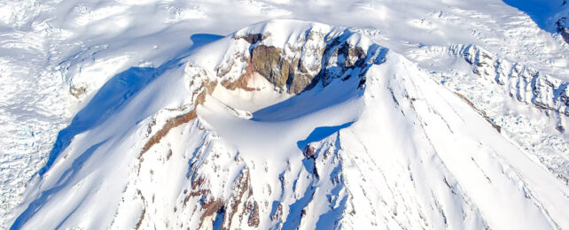
Mount Spurr prominent volcano in Alaska is showing signs of renewed volcanic unrest including elevated seismic activity & gas emissions prompting monitoring agencies to warn of a potential eruption.
|
Category |
Details |
|
Volcano Name |
Mount Spurr |
|
Type |
Stratovolcano (also called a composite volcano) |
|
Location |
Alaska, USA Part of Aleutian Volcanic Arc located approximately 80 miles (130 km) west of Anchorage |
|
Elevation |
Approximately 11,070 feet (3,374 meters) above sea level |
|
Coordinates |
61.299°N, 152.251°W |
|
Geological Zone |
Located along Pacific Ring of Fire a seismically active area of subduction zones around Pacific Ocean |
|
Volcanic Arc |
Aleutian Arc Formed due to subduction of Pacific Plate beneath North American Plate |
|
Nearby Features |
Lies near Cook Inlet; neighboring volcanoes include Redoubt & Augustine |
|
Crater Peaks |
Summit Peak Main cone |
|
Eruption Year |
Type of Eruption |
Details |
|
1953 |
Explosive eruption from Crater Peak |
Produced ash clouds that disrupted air traffic. |
|
1992 |
VEI-4 eruption from Crater Peak |
Series of eruptions July–September; ash fall reached Anchorage; significant air traffic disruptions in Southcentral Alaska. |
|
Historical |
Lava flows, ash plumes |
Mount Spurr has been active over Holocene epoch producing andesitic to dacitic lava flows & tephra. |
|
Parameter |
Details |
|
Alert Level |
YELLOW (Advisory) Elevated signs of unrest without confirmed eruption |
|
Gas Emissions |
High levels of CO₂ measured at summit & crater peak (detected during March 2025 AVO flight) |
|
Steam/Gas Vents |
Newly opened gas vents emitting visible steam & volcanic gases |
|
Earthquake Swarm |
Over 3,400 earthquakes recorded under volcano since April 2024 with more than 100 per week recently |
|
Volcanic Gas Composition |
Primarily CO₂, with SO₂ & H₂S likely components (typical for pre-eruptive degassing) |
|
Seismicity Trends |
Earthquakes are mostly low-magnitude (< M3.0), shallow & clustered below Crater Peak indicating magma movement or pressurization |
|
Surface Changes |
Signs of surface heating & increased fumarolic activity observed during aerial surveillance |
|
AVO Monitoring Tools |
Seismometers |
|
Potential Eruption Window |
Observers estimate eruption could occur in next weeks to months if unrest escalates |
Eruption Forecasting & Risk
|
Forecast Method |
Indicators Used |
|
Seismic Monitoring |
Earthquake frequency, depth & location indicate magma movement |
|
Gas Emissions |
Elevated CO₂ & SO₂ suggest degassing of rising magma |
|
Ground Deformation |
Monitored using GPS & InSAR satellites to detect inflation from magma accumulation |
|
Thermal Imaging |
Used to detect increased surface temperatures & potential lava activity |
|
Historical Comparison |
Patterns compared with 1992 & 1953 eruptions short-duration ash-rich events |
|
Aspect |
Impact/Concern |
|
Proximity to Anchorage |
At just 80 miles ash fallout & air travel disruption pose a significant hazard to populated areas |
|
Air Traffic Disruption |
Ash plumes from previous eruptions (e.g. 1992) severely disrupted flights in Southcentral Alaska |
|
Ashfall Zones |
Ash clouds can travel far impacting regions hundreds of kilometers away especially during wind events |
|
Human Risk |
Remote location means low direct hazard to life but economic & transport disruptions are expected |
|
Global Relevance |
Details |
|
Pacific Ring of Fire |
Mount Spurr is part of one of world’s most volcanically & seismically active regions |
|
Tectonic Setting |
Subduction of Pacific Plate beneath North American Plate key driver of Aleutian Arc volcanism |
|
Comparative Volcanoes |
Nearby volcanoes like Redoubt, Augustine & Katmai have similar eruptive styles & hazards |
For more information, please refer to IAS GYAN
Sources:
|
PRACTICE QUESTION Q. Volcanoes along subduction zones like Aleutian Arc pose both regional & global risks." Examine tectonic setting of Mount Spurr & its implications for disaster management. |


© 2026 iasgyan. All right reserved


