Source: NEWSX
Disclaimer: Copyright infringement not intended.
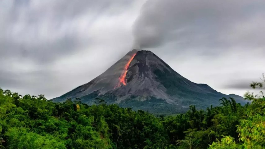
Mount Lewotobi in Indonesia East Nusa Tenggara erupted spewing a 3,500 metre ash column & prompting orange-level aviation alerts, evacuation advisories & safety warnings for residents near active volcano.
|
Feature |
Details |
|
Location |
Flores Island, East Nusa Tenggara province, Indonesia |
|
Coordinates |
Approximately 8.5° S, 122.8° E |
|
Type |
Stratovolcano (composite volcano) |
|
Composition |
Andesitic to basaltic andesite |
|
Part of |
Pacific Ring of Fire |
|
Peaks |
Two main peaks Lewotobi Lakilaki (1584 m) & Lewotobi Perempuan (1703 m) |
|
Separation |
2 km separated by a saddle of 1232 m elevation |
|
Crater Features |
Lakilaki 400 m wide open to north; Perempuan 700 m wide |
|
Flank Cone |
Iliwokar on east flank of Lewotobi Perempuan |
|
Historical Eruptions |
Lakilaki Frequent activity in 19th–20th century; Perempuan Only two historical eruptions |
|
2024 Activity |
Major eruption with ash plumes up to 8,000 m; aviation warning issued (Orange Level) |
|
Volcanic Hazards |
Ashfall, hot clouds, lava flows, lahars during rainfall |
|
Local Response |
6 km exclusion zone; facemask advisory; aviation rerouting below 5,000 m |
|
Nearby Settlement Risk |
High due to proximity of human habitation & farming communities |
|
Feature |
Details |
|
Type |
Major tectonic plate |
|
Boundaries |
Converges with Indian, Arabian & Philippine Sea plates |
|
Interaction with Indo-Australian Plate |
Subduction of Indo-Australian Plate beneath Eurasian Plate creates volcanic arcs |
|
Relevance to Indonesia |
Forms northern boundary; causes volcanism & earthquakes |
|
Geological Significance |
Part of complex Sunda Arc tectonic interaction |
|
Feature |
Details |
|
Type |
Major tectonic plate |
|
Boundary Type |
Convergent (subducts under Eurasian Plate) |
|
Motion Direction |
Northward at ~7 cm/year |
|
Interaction with Indonesia |
Responsible for Sunda Trench & volcanic arc in Java-Sumatra chain |
|
Importance |
Drives seismicity in southern Indonesian region |
|
Feature |
Details |
|
Type |
Largest tectonic plate |
|
Motion Direction |
Westward movement |
|
Plate Boundaries |
Interacts with Philippine Sea, North American & Indo-Australian plates |
|
Indonesia Relevance |
Less direct than Eurasian/Australian but contributes to broader Pacific seismicity |
|
Key Feature |
Dominates Ring of Fire encircling Pacific Basin |
|
Feature |
Details |
|
Location |
Extends from northern Sumatra through Java, Bali, Lombok, Sumbawa, Flores, to Banda Sea |
|
Tectonic Setting |
Formed by subduction of Indo-Australian Plate beneath Eurasian Plate |
|
Arc Type |
Continental volcanic arc |
|
Length |
Over 3,000 km |
|
Key Islands |
Sumatra, Java, Bali, Lombok, Sumbawa, Flores, Wetar |
|
Oceanic Feature |
Lies above Sunda Trench a major subduction zone |
|
Major Volcanoes |
Mount Merapi, Mount Agung, Mount Bromo, Mount Rinjani, Mount Tambora, Mount Lewotobi |
|
Plate Interaction |
Indo-Australian Plate (subducting) & Eurasian Plate (overriding) |
|
Volcanic Activity |
High includes several of world’s most explosive & active volcanoes |
|
Hazards |
Earthquakes, tsunamis, pyroclastic flows, lahars, ashfall, volcanic lightning |
|
Most Famous Eruption |
Mount Tambora (1815) largest eruption in recorded history; caused “Year Without a Summer” |
|
Modern Monitoring |
Managed by Indonesia PVMBG (Volcanology & Geological Hazard Mitigation Centre) |
|
Geological Importance |
Vital for understanding plate tectonics, subduction volcanism & hazard mitigation |
|
Aspect |
Details |
|
Subduction Zone |
Indo-Australian Plate descends below Eurasian Plate |
|
Trench System |
Sunda Trench (a deep oceanic trench parallel to arc) |
|
Magma Generation |
Caused by water-rich oceanic crust melting in mantle wedge forming andesitic magma |
|
Seismicity |
Frequent earthquakes due to plate movement; includes megathrust & deep-focus quakes |
|
Tsunami Potential |
High especially where underwater quakes rupture sea floor (e.g., 2004 Indian Ocean Tsunami) |
|
Banda Arc Connection |
The eastern end transitions into complex Banda Arc involving multiple microplates |
|
Economic Impact |
Affects agriculture, infrastructure & human settlement due to fertile soils but high risk |
|
Volcano |
Island |
Elevation (m) |
Last Major Eruption |
Notes |
|
Mount Merapi |
Java |
2,963 |
2023 |
Most active volcano in Indonesia |
|
Mount Tambora |
Sumbawa |
2,850 (after 1815) |
1815 |
Deadliest eruption in history |
|
Mount Agung |
Bali |
3,031 |
2019 |
Known for 1963 catastrophic eruption |
|
Mount Rinjani |
Lombok |
3,726 |
2016 |
Second highest in Indonesia |
|
Mount Lewotobi |
Flores |
1,703 / 1,584 |
2024 |
Twin volcano, recent aviation alerts issued |
For more such articles, please refer to IAS GYAN
Sources:
|
PRACTICE QUESTION Q. Sunda Arc exemplifies dynamic interaction of tectonic plates shaping Southeast Asian geography & hazards. Examine geological significance & implications of volcanic activity along Sunda Arc for regional disaster preparedness. |


© 2026 iasgyan. All right reserved


