Disclaimer: Copyright infringement not intended.
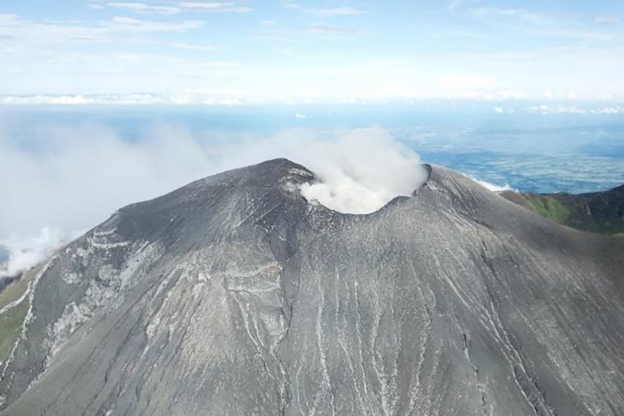
Mount Kanlaon one of Philippines most active volcanoes erupted highlighting seismic vulnerability of regions within Pacific Ring of Fire & importance of disaster preparedness.
|
Feature |
Description |
|
Location |
North central part of Negros Island Philippines |
|
Geographic Coordinates |
Approximately 10.4°N, 123.1°E |
|
Type |
Stratovolcano large, steep sided volcano built by many layers of hardened lava, tephr & volcanic ash |
|
Volcanic Arc/Belt |
Part of Negros Volcanic Belt situated within Pacific Ring of Fire |
|
Elevation |
2,465 meters (8,087 feet) above sea level |
|
Crater Structure |
Elongated northern caldera with a crater lake |
|
Volcanic Composition |
Sheeted lava flows, lahar deposits, airfall tephra & pyroclastic aprons from past eruptions |
|
Crater Dimensions |
Active southern crater: ~2 km wide |
|
Volcanic Features |
Multiple pyroclastic cones, volcanic domes & craters within & around summit |
|
Biological Significance |
Rich biodiversity hotspot |
|
Hydrological Importance |
Source of major rivers including Bago & Magballo |
|
Eruption Style |
Typically phreatic explosions (steam-driven), sometimes Strombolian |
|
Historical Eruptions |
Recorded since 1866; eruptions generally involve ash clouds & minor ashfall |
|
Recent Eruptions |
December 2024 |
|
Hazards |
Ashfall, lahars, pyroclastic flows, volcanic gases, potential lava fountaining |
|
Nearby Populations |
Towns & villages within 4–6 km danger zone; periodic evacuations |
|
Monitoring Agency |
PHIVOLCS Philippine Institute of Volcanology & Seismology |
|
Protected Status |
Designated as part of Mount Kanlaon Natural Park (MKNP) |
|
Volcano Name |
Location |
Elevation (m) |
Last Known Eruption |
|
Mayon |
Albay, Luzon |
2,462 |
2023 |
|
Taal |
Batangas, Luzon |
311 |
2022 |
|
Kanlaon |
Negros Island |
2,465 |
2025 |
|
Bulusan |
Sorsogon, Luzon |
1,565 |
2022 |
|
Hibok-Hibok |
Camiguin Island |
1,332 |
1952 |
|
Smith Volcano |
Babuyan Islands |
688 |
1924 |
|
Babuyan Claro |
Babuyan Islands |
1,000 |
1860 |
|
Didicas |
Cagayan |
244 |
1978 |
|
Cagua |
Cagayan |
1,133 |
1860 |
|
Iraya |
Batanes |
1,009 |
~1454 |
|
Pinatubo |
Zambales |
1,486 |
1991 |
|
Arayat |
Pampanga |
1,026 |
Unconfirmed |
|
Makaturing |
Lanao del Sur |
1,940 |
1882 |
|
Matutum |
South Cotabato |
2,286 |
1911 |
|
Parker |
South Cotabato |
1,824 |
1641 |
|
Ragang |
Lanao del Sur |
2,815 |
1916 |
|
Apo |
Davao |
2,954 |
Fumarolic |
|
Musuan |
Bukidnon |
646 |
1886 |
|
Biliran |
Biliran Island |
1,340 |
1939 |
|
Leonard Kniaseff |
Davao del Norte |
1,190 |
120 AD (est.) |
|
Malindang |
Misamis Occidental |
2,404 |
Unknown |
|
Cuernos de Negros |
Negros Island |
1,186 |
Unknown |
|
Mandalagan |
Negros Island |
1,885 |
Unknown |
|
Latukan |
Lanao del Sur |
2,280 |
Unknown |
|
Alert Level |
Description |
Recommended Actions |
|
0 |
Normal No volcanic activity |
No action needed |
|
1 |
Low level unrest |
Entry into permanent danger zone not advised |
|
2 |
Increasing unrest |
Evacuation of danger zone recommended |
|
3 |
Increased tendency toward hazardous eruption |
High alert, evacuation within 6 km radius |
|
4 |
Hazardous eruption imminent |
Full evacuation, emergency measures in place |
|
5 |
Hazardous eruption in progress |
Catastrophic situation – all mitigation & emergency responses active |
|
Feature |
Details |
|
Full Name |
Philippine Institute of Volcanology & Seismology |
|
Parent Organization |
Department of Science & Technology (DOST) |
|
Headquarters |
Quezon City, Philippines |
|
Functions |
Monitoring volcanoes, earthquakes & tsunamis in Philippines |
|
Tools Used |
Seismic sensors, satellite imagery, drone surveys, gas emission tools |
|
Key Programs |
Volcano Alert System, Earthquake Monitoring, Hazard Mapping |
|
Public Communication |
Alert Bulletins, Risk Advisories, Evacuation Warnings |
|
International Cooperation |
With USGS, JMA (Japan) & global volcano research bodies |
|
Volcanic Belt |
Location |
Key Features |
Notable Volcanoes |
|
Andean Volcanic Belt |
Along western edge of South America (Chile, Peru, Ecuador, Colombia, Argentina) |
Formed due to subduction of Nazca Plate beneath South American Plate |
Cotopaxi, Ojos del Salado, Llaima, Villarrica |
|
Central American Volcanic Arc |
Southern Mexico through Central America |
Result of Cocos Plate subducting beneath Caribbean Plate |
Fuego, Arenal, Pacaya, Momotombo |
|
Cascadia Volcanic Arc |
Pacific Northwest of USA & Canada |
Caused by Juan de Fuca Plate subducting under North American Plate |
Mount St. Helens, Mount Rainier, Mount Hood |
|
Alaska-Aleutian Volcanic Arc |
Alaska & Aleutian Islands |
Created by Pacific Plate subducting under North American Plate |
Mount Redoubt, Mount Shishaldin, Mount Katmai |
|
Kuril–Kamchatka Arc |
Russian Far East (Kuril Islands to Kamchatka Peninsula) |
Subduction of Pacific Plate beneath Okhotsk Plate |
Klyuchevskoy, Shiveluch, Bezymianny |
|
Japan Arc |
Japanese islands |
Formed by subduction of Pacific & Philippine Sea Plates under Eurasian Plate |
Mount Fuji, Sakurajima, Aso |
|
Ryukyu Arc |
Southern Japan to Taiwan |
Result of Philippine Sea Plate subducting under Eurasian Plate |
Suwanosejima, Iriomote, Kikai |
|
Izu-Bonin-Mariana Arc |
South of Japan to Micronesia |
Formed by Pacific Plate subducting under Philippine Sea Plate |
Mount Pagan, Agrihan, Anatahan |
|
Philippine Volcanic Arc |
Philippines |
Due to multiple plate interactions (Philippine Sea, Eurasian, Pacific plates) |
Mayon, Taal, Mount Kanlaon |
|
Sunda Arc (Indonesia) |
Indonesia & part of Southeast Asia |
Created by Indo-Australian Plate subducting beneath Eurasian Plate |
Mount Merapi, Krakatoa, Mount Tambora |
|
New Guinea–Solomon Arc |
Papua New Guinea & Solomon Islands |
Formed by complex microplate & subduction dynamics |
Ulawun, Manam, Bagana |
|
Tonga–Kermadec Arc |
Tonga & Kermadec Islands |
Subduction of Pacific Plate under Indo-Australian Plate |
Hunga Tonga–Hunga Ha'apai, Monowai |
|
New Zealand Volcanic Zone |
North Island of New Zealand |
Includes Taupo Volcanic Zone, formed by subduction of Pacific Plate |
Mount Ruapehu, Mount Tongariro, White Island (Whakaari) |
For more information, please refer to IAS GYAN
Sources:
|
PRACTICE QUESTION Q. Discuss tectonic settings of Pacific Ring of Fire & examine how they contribute to distribution of active volcanoes & seismic activity around Pacific Ocean basin. |


© 2026 iasgyan. All right reserved


