Disclaimer: Copyright infringement not intended.
In a major urban rejuvenation initiative Telangana government is set to redevelop Mir Alam Tank & Musi River with modern infrastructure, sustainable tourism features & hydrological safeguards to boost Hyderabad domestic & international appeal.
|
Feature |
Details |
|
Location |
Hyderabad, Telangana |
|
Constructed By |
Mir Alam Bahadur (Prime Minister of Hyderabad) |
|
Year of Construction |
1804 to 1806 |
|
Architectural Significance |
21 arches; an engineering marvel of its time |
|
Original Purpose |
Drinking water supply to Hyderabad |
|
Current Status |
Historical water reservoir, used for boating & tourism |
|
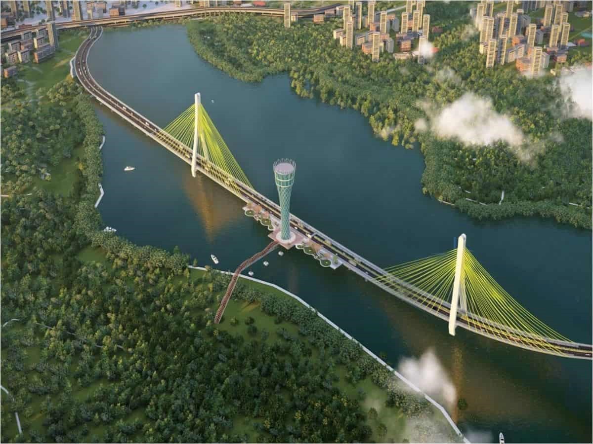
Bridge Project (2025 Plan) |
2.5 km bridge with 3 island zones |
|
Proposed Island Zones |
Bird Paradise, amphitheatre, adventure & theme parks, resorts |
|
Governance |
Telangana State Government |
|
Tourism Vision |
Inspired by Gardens by Bay, Singapore |
|
Environmental Concerns |
Need for hydrological & environmental impact assessment |
|
Development Mode |
Public Private Partnership (PPP) |
|
Parameter |
Details |
|
Origin |
Ananthagiri Hills, Vikarabad district, Telangana |
|
Total Length |
~240 km |
|
Empties Into |
Krishna River near Wadapally, Nalgonda district |
|
States Covered |
Telangana |
|
Major Cities Along Course |
Hyderabad, Nalgonda |
|
Historical Significance |
Hyderabad was founded on banks of Musi River in 1591 by Muhammad Quli Qutb Shah; several heritage structures (e.g. Charminar, Osmania General Hospital) stand close to river. |
|
Major Tributaries |
Left Bank Esa River, Nakkavagu |
|
Important Dams / Reservoirs |
Osmansagar (Gandipet) Built in 1920 on Musi for Hyderabad drinking water |
|
Key Bridges/Crossings |
Afzalgunj Bridge, Salarjung Bridge, Moosarambagh Bridge |
|
Urban Impact Zones |
Hyderabad city is split by Musi River; major slums, sewer outlets & encroachments are situated along riverbanks |
|
Pollution Status |
Heavily polluted due to direct discharge of untreated sewage, industrial effluents; listed as a critically polluted river stretch by CPCB |
|
Parks & Green Zones |
Musi Riverfront Urban Park (proposed) |
|
Musi Rejuvenation Project (2024–2025) |
Part of Telangana government initiative |
|
Floods & Hazards |
Notable flood in 1908 which devastated Hyderabad; led to construction of Osmansagar & Himayatsagar |
|
Recent Development Projects |
Mir Alam Tank artificial island bridge project |
|
Ecological Challenges |
River biodiversity loss |
|
Key Stakeholders |
Hyderabad Metropolitan Water Supply & Sewerage Board (HMWSSB) |
|
Parameter |
Details |
|
Location |
Bapu Ghat, Langar Houz, Hyderabad, Telangana |
|
Geographical Context |
Situated on banks of Musi River; near confluence of historic, religious & civic landmarks |
|
Name Significance |
Named Gandhi Sarovar as part of memorial space at Bapu Ghat where ashes of Mahatma Gandhi were immersed |
|
Nature of Water Body |
Artificial reservoir/tank |
|
Associated River |
Musi River |
|
Current Status (as of 2024–25) |
Under proposed redevelopment & rejuvenation plan by Telangana Government; to be transformed into a key site under Musi River Rejuvenation & Urban Beautification Project |
|
Planned Features (2024 Plan) |
Landscape beautification |
|
Proposed Connectivity |
Integrated into broader tourism corridor connecting |
|
Relevance to Musi Project |
Acts as one of nodal points in reviving riverine ecology & heritage; being developed as a symbolic green & cultural site |
|
Hydrological Role |
Not a major flood absorption zone but contributes to local recharge & landscape retention |
|
Public Use & Civic Impact |
Site for public homage, civic ceremonies |
|
Environmental & Ecological Plans |
Plantation of native trees |
|
Administrative Bodies Involved |
Hyderabad Metropolitan Development Authority (HMDA) |
|
Challenges |
Encroachment around nearby zones |
|
Cultural Heritage Angle |
Bapu Ghat & Gandhi Sarovar form part of Telangana freedom movement heritage tourism |
|
Artificial Island |
Location |
State/UT |
Year of Creation / Initiation |
Size / Area |
Purpose / Use |
Key Features / Developments |
|
Willingdon Island |
Kochi (Cochin Port) |
Kerala |
1936 (completed) |
~775 acres (3.13 sq. km) |
Port, commercial, naval operations |
Largest artificial island in India; created during British rule by dredging; houses Cochin Port Trust, Naval Base, Custom Office, luxury hotels |
|
Jawahar Dweep (Butcher Island) |
Mumbai Harbour |
Maharashtra |
1940s (WWII) |
~300 acres (1.21 sq. km) |
Oil terminal, restricted naval use |
Used by Indian Oil Corporation for handling petroleum products; strategic & security-sensitive zone |
|
Middle Ground Coastal Battery |
Arabian Sea, Mumbai |
Maharashtra |
British-era |
Very small (~0.3 acres) |
Naval defense |
Old coastal defense fort; currently operated by Indian Navy |
|
Elephanta Island (semi-artificial extensions) |
Mumbai Harbour |
Maharashtra |
Ancient-natural core; artificial modifications added later |
~16 sq. km (includes natural + reclaimed) |
Tourism, heritage (UNESCO site) |
Though primarily natural, some parts & extensions have been reclaimed; caves are protected monuments |
|
Raja Bhoj Island (Bada Talab, Bhojtal) |
Bhopal (Upper Lake) |
Madhya Pradesh |
21st century (developed as tourism project) |
~2.5 acres |
Tourism, cultural site |
Island hosts Raja Bhoj statue; plans for further development as a lakefront attraction |
|
Mir Alam Tank Islands (Proposed) |
Hyderabad |
Telangana |
Proposed in 2024–25 |
To be determined (3 island zones planned) |
Eco-tourism, entertainment, convention |
Part of Telangana’s Musi River Rejuvenation project; themed after Gardens by Bay (Singapore) |
|
Sabarmati Riverfront Islands (conceptual) |
Ahmedabad |
Gujarat |
Ongoing (Riverfront Phase 2) |
Not yet fully implemented |
Urban green zones, tourism |
Artificial islands proposed as ecological parks & leisure areas as part of riverfront beautification |
|
Marine Drive Reclamation Zones |
Mumbai |
Maharashtra |
1940s–1970s |
Reclaimed land area forming promenades & parks |
Urban expansion |
While not islands, parts of coastline were artificially reclaimed into island-like parks & promenades |
|
Nehru Park Island (Hussain Sagar Lake) |
Hyderabad |
Telangana |
1960s |
~1 acre |
Public park, tourism |
Located within Hussain Sagar, accessed via boat; created by minor land reclamation |
|
Ekta Nursery Island (around Statue of Unity) |
Kevadia (Sardar Sarovar) |
Gujarat |
2018–20 |
~2.5–3 acres |
Ecotourism, biodiversity, nursery |
Developed as an artificial landform in Narmada backwaters; near Valley of Flowers |
Mir Alam Tank vs Musi River vs Gandhi Sarovar vs Other Artificial Islands in India
|
Feature / Project Aspect |
Mir Alam Tank Project |
Musi River Rejuvenation |
Gandhi Sarovar Project |
Artificial Islands in India (General) |
|
Location |
Hyderabad, Telangana |
Hyderabad, Telangana |
Near Bapu Ghat, Hyderabad |
Gujarat, Kerala, Karnataka, Telangana (planned) |
|
Historical Context |
Built in 1804–06 by Mir Alam Bahadur |
River with historic flooding & urban linkage |
Site linked to Gandhi ashes immersion |
Mostly modern or port-based (e.g. Willingdon, Kadamba) |
|
Main Objective |
Bridge & island tourism hub |
Rejuvenation, pollution control, tourism |
Cultural & historical zone restoration |
Varied: tourism, ports, defence, beautification |
|
Architectural Vision |
Inspired by Gardens by Bay, Singapore |
Riverfront development, eco-restoration |
Memorial, gardens, pathways |
Depends on island; some reclaimed, some landscaped |
|
Key Features |
2.5 km bridge, 3 islands, Bird Paradise, resorts |
Boating, theme parks, flood mitigation |
Walkways, gardens, memorial integration |
Parks, convention centres, naval bases, trade ports |
|
Tourism Focus |
Strong – Adventure, Eco-tourism, Family Leisure |
Moderate Linked with Mir Alam & Gandhi Sarovar |
Cultural & heritage based |
High Gujarat Ekta Island, Kerala Willingdon |
|
Governance & Implementation |
Telangana Govt. with PPP mode |
State-led with multi-departmental integration |
Telangana Government |
State + Central Government (depending on use case) |
|
Environmental Measures |
Hydrological survey, water availability mapping |
Environmental assessment, sewage treatment plan |
Landscaping & eco sensitive redevelopment |
Reclamation norms, marine impact assessments (varied) |
|
Public Access |
Full access planned with safety features |
Public spaces, boating, riverwalks |
Open cultural space |
Mostly accessible some restricted (naval/ports) |
|
Timeline |
DPR by mid-2025; tenders by June 2025 |
Ongoing in phases |
Parallel with Musi & Mir Alam projects |
Varies by project multi-year development cycles |
|
International Influence |
Gardens by Bay (Singapore) |
Thames Riverfront, Sabarmati Riverfront |
National memorial designs |
Dubai's Palm Islands (tourism), Singapore's islets |
|
Feature / Aspect |
Palm Jumeirah (UAE) |
The Pearl (Qatar) |
Odaiba (Japan) |
Forest City (Malaysia) |
The World Islands (UAE) |
|
Country / City |
Dubai, UAE |
Doha, Qatar |
Tokyo, Japan |
Johor Bahru, Malaysia |
Dubai, UAE |
|
Construction Period |
2001–2006 (ongoing expansions) |
2004–2012 |
1990s–2000s (ongoing upgrades) |
2014–present |
2003–onward (partially stalled) |
|
Type |
Artificial Palm-shaped archipelago |
Artificial mixed-use island |
Reclaimed land from Tokyo Bay |
Reclaimed island with smart infrastructure |
Artificial world-map shaped islands |
|
Tourism Purpose |
Luxury tourism, hospitality, beachfront living |
High-end leisure, marina lifestyle |
Urban entertainment & leisure zone |
Eco-tourism, real estate & green living |
Exclusive island tourism (planned luxury resorts) |
|
Key Attractions |
Atlantis The Palm, Aquaventure Waterpark |
Porto Arabia Marina, high-end restaurants |
TeamLab Borderless, Oedo Onsen Monogatari |
Mangrove parks, duty-free zone, golf resorts |
Concept based islands (e.g., Europe, Asia) |
|
Architectural Inspiration |
Palm tree shape (symbolic & iconic) |
Mediterranean/Arabesque coastal architecture |
Futuristic urban design |
Smart forest cities (Chinese green-tech design) |
World continents & countries layout |
|
Environmental Strategy |
Wave-breakers, underwater marine preservation |
Water recycling, energy-efficient designs |
Green transport, controlled development |
Carbon-neutral ambition, vertical greening |
Lacks environmental focus; criticized |
|
Governance Model |
UAE Government + Nakheel Properties |
Qatari Government + UDC |
Japan Government + Tokyo Municipal Authorities |
Chinese Developer (Country Garden) + Malaysia |
Private investors (Nakheel) + UAE Government |
|
Development Challenges |
Erosion, marine disruption, costly maintenance |
Rising construction costs, exclusivity critique |
Earthquake-proofing, land subsidence risk |
Environmental displacement, investor skepticism |
Maintenance issues, buyer withdrawal, stalling |
|
Global Tourism Appeal |
Very high global icon |
Moderate elite regional market |
High part of Tokyo tourism circuit |
Moderate rising among green travel circles |
Low vision remains incomplete |
|
Accessibility |
Metro, monorail, taxis |
Bridge, road access |
Tokyo Metro + Rainbow Bridge |
Road/port + mainland proximity |
Limited boat/helicopter (when operational) |
|
Status |
Operational with expansions |
Operational |
Fully operational |
Partially operational, expanding in phases |
Partially built, mostly dormant |
|
Cultural Integration |
Low luxury & expat oriented |
Medium luxury with some Qatari design |
High blends tech, culture, leisure |
Low residential focused with some cultural shows |
For more such articles, please visit IAS GYAN
Sources:
|
PRACTICE QUESTION Q. Artificial island tourism zones are new frontiers of urban leisure but also ecological risk zones. Critically analyse with global & Indian examples. |


© 2026 iasgyan. All right reserved


