Description
Disclaimer: Copyright infringement not intended.
Context: Two United States Senators, a Republican and a Democrat, have introduced a bipartisan resolution in the upper chamber of Congress reiterating that the US recognises the McMahon Line as the international boundary between China and India in Arunachal Pradesh.
Details:
- The resolution reaffirms India’s well-known and established position that Arunachal Pradesh, which China calls ‘South Tibet’, is an integral part of India.
.jpeg)
What is the McMahon Line?
- The McMahon Line serves as the de facto boundary between China and India in the Eastern Sector.
- It specifically represents the boundary between Arunachal Pradesh and Tibet, from Bhutan in the west to Myanmar in the east.
- China has historically disputed the boundary and claims the state of Arunachal Pradesh as part of the Tibetan Autonomous Region (TAR).
- The McMahon Line was drawn during the Simla Convention of 1914, officially described as the Convention Between Great Britain, China, and Tibet.
- China was represented at the convention by the government of the Republic of China, which was in power in the mainland from 1912 to 1949, when its leaders were driven to the island of Taiwan during the civil war that established the communists in Beijing and led to the proclamation of the People’s Republic.
- The McMahon Line delimited the respective spheres of influence of Tibet and British India in the eastern Himalayan region in what is today India’s Northeast and northern Myanmar.
- The border in this region was undefined prior to the signing of the convention.
What happened at the Simla Convention of 1913-14?
- The convention attempted to settle the question of Tibet’s sovereignty and avoid further territorial disputes in the region.
- The Tibetan government in Lhasa was represented by its plenipotentiary Paljor Dorje Shatra, and Britain by Sir Arthur Henry McMahon, foreign secretary of British India at Delhi. The Chinese plenipotentiary was Ivan Chen.
- The treaty divided the Buddhist region into “Outer Tibet” and “Inner Tibet” – the former would “remain in the hands of the Tibetan Government at Lhasa under Chinese suzerainty”, though China was not allowed to interfere in its affairs. The latter would be under the direct jurisdiction of the newly formed Republic of China.
- In its annexes, it also determined the border between China proper and Tibet as well as Tibet and British India.
- The latter of these newly decided boundaries would later be called the McMahon Line after McMahon, the chief British negotiator.
- While a draft convention was agreed upon by all three countries on April 27, 1914, China immediately repudiated it.
- The final convention was only signed by McMahon on behalf of the British government and Shatra on behalf of Lhasa.
- Ivan Chen did not consent to the convention, arguing that Tibet had no independent authority to enter into international agreements.

What has the status of the McMahon line been since 1914?
- While there were disputes regarding the McMahon line from the very beginning, after the communists took power in 1949, they pulled China out of all international agreements and the so-called “unequal treaties” that had been imposed on it during its “century of humiliation”, and demanded a renegotiation of all its borders.
- During the 1962 Sino-Indian War, China was able to quickly overpower India and make deep inroads into Indian territory across the McMahon Line.
- However, its forces retreated to pre-war positions after the unilateral ceasefire was announced on November 21.
India-China border issue:
- India-China-relations dates back to more than 2,000 years ago. There have been cultural and economic ties between the two countries since ancient times.
- Relations between contemporary China and India have been characterized by border disputes, resulting in military conflicts like — the Sino-Indian War of 1962, the Chola incident in 1967, the 1987 Sino-Indian and the 2020 India-China skirmish.
- Relations between India and China have come under “severe stress” time and again in the last decade due to multiple border stand-offs along the Line of Actual Control.
Root cause of border dispute between India & China:
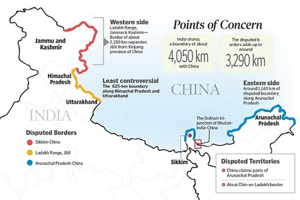
- The root cause lies in an ill-defined, 3,440km (2,100-mile)-long border that both countries dispute. Four states - Himachal Pradesh, Uttarakhand (erstwhile part of UP), Sikkim and Arunachal Pradesh and Union Territories of Ladakh (erstwhile state of Jammu & Kashmir) share a border with China.
- The Sino-Indian border is generally divided into three sectors namely: Western sector, Middle sector, and Eastern sector.

Western Sector
- In the western sector, India shares about a 2152 km border with China.
- It is between the union territory of Ladakh (erstwhile state of Jammu and Kashmir) and the Xinjiang province of China.
- The territorial dispute in the western sector is over Aksai Chin. India claims it as part of erstwhile Kashmir, while China claims it is part of Xinjiang.
- The dispute is said to be due to the failure of the British empire as it failed to demarcate a legal border between both countries. During the British rule in India two borderlines were proposed – Johnson’s line and McDonald line in 1865 and 1893 respectively.
- The Johnson’s line shows Aksai Chin in Ladakh i.e. under India’s control whereas McDonald Line places it under China’s control. India considers Johnson Line as a rightful national border with China, while on the other hand, China considers the McDonald Line as the correct border with India.
- The different claims and perceptions of LAC have led to an overlapping area, within that area lies a small zone which both the sides patrol causing clashes of the Indian and the Chinese army.
- At present, Line of Actual Control (LAC) is the line separating Indian areas of Ladakh from Aksai Chin. It is concurrent with the Chinese Aksai Chin claim line.
Middle Sector
- In the middle sector, India shares about 625km of the border with China. This is the only sector where the both countries have less disagreement. The border runs from Ladakh to Nepal.
- The states of Himachal Pradesh and Uttarakhand touch the border with Tibet in this sector.
Eastern Sector
- In the eastern sector, India shares 1140 km boundary with China. The boundary line is called McMahon Line runs from the eastern limit of Bhutan to a point near the Talu Pass at the trijunction of Tibet, India, and Myanmar.
- The majority of the territory of Arunachal Pradesh is claimed by China as a part of Southern Tibet.
- China considers the McMahon line illegal. McMahon proposed the line in the Simla Accord in 1914 to settle the boundary between Tibet and India, and Tibet and China. Though the Chinese representatives at the meeting initialled the agreement, they subsequently refused to accept it.
|
PRACTICE QUESTION
Q) Discuss in brief the root cause of the border dispute between India and China. (150 words)
|

https://economictimes.indiatimes.com/news/india/us-recognises-mcmahon-line-as-international-boundary-between-india-and-china/videoshow/98658245.cms