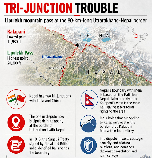
The India-Nepal border dispute primarily centers on Kalapani, Lipulekh, Limpiyadhura, and Susta. Rooted in the 1816 Treaty of Sugauli's ambiguous river demarcations and natural river shifts, it impacts strategic security, bilateral relations, and demands diplomatic resolution and joint surveys.
Nepal’s newly elected leadership shifts the diplomatic discourse by advocating for a rational, objective, and evidence-based resolution to the long-standing boundary disputes with India.
|
Read all about: India-Nepal Bilateral Relations |
Strategic Tri-junction: The dispute centers on a 372-square-kilometer area comprising Kalapani, Lipulekh, and Limpiyadhura, located at the northwestern tip of Nepal and the northern border of Uttarakhand.
Geopolitical Significance: The region overlooks the Lipulekh Pass, which serves as a critical trade route and the primary corridor for the Kailash Mansarovar Yatra to Tibet.
The Treaty of Sugauli (1816): Signed after the Anglo-Nepalese War, establishes the River Kali as the western boundary of Nepal but fails to define the river's exact geographic source.
Competing Claims: Nepal asserts that the river originates at the westernmost stream at Limpiyadhura, while India maintains that the river begins at a ridge line near Kalapani, consistent with British India maps from 1847.
|
Political Shift In Kathmandu Youth-Led Governance: The rise of the RSP and leaders like Balendra Shah reflects a generational shift toward transparent, performance-oriented governance that prioritizes economic development over historical grievances. Sovereign Equality: The new administration treats India as an equal sovereign partner, bypassing traditional "special relationship" protocols in favor of a modern, rules-based diplomatic engagement. Objective Assessment: Prime Minister Shah emphasizes resolving border issues through historical facts, mutual trust, and direct dialogue rather than populist nationalist posturing. |
Cartographic Ambiguity
Reliance on contradictory British-era maps creates persistent confusion, as various colonial-era surveys utilized different technologies and standards.
Security Concern
India maintains administrative control over the status quo zone to protect vital defensive lines along the China border, making territorial concessions highly unlikely.
Domestic Nationalism
Traditional political factions in Nepal frequently weaponize anti-India sentiment to score domestic political points during times of crisis.
Bureaucratic Stagnation
Complex boundary issues often languish in expert-level committees, allowing minor disputes to evolve into long-term diplomatic irritants.
Leveraging Open Borders
Both nations should utilize the existing 1,700-kilometer open-border system as a model for cooperation, drawing inspiration from the pre-1962 era of seamless movement.
Institutional Army-to-Army Ties
The two nations must utilize the deep, mutually trusting relationship between the Indian and Nepalese Armies to facilitate quiet, practical border solutions.
Economic Integration
Prioritizing cross-border energy grids, digital commerce networks, and transport infrastructure ensures that boundary disputes do not obstruct regional economic growth.
Joint Management
Both countries should explore innovative models, such as shared environmental preservation zones or joint border administration corridors, to manage disputed areas without compromising sovereign claims.
Regular High-Level Political Engagement
Leaders must bypass rigid bureaucratic habits by utilizing direct communication channels to resolve policy challenges with transparency and speed.
Confidence-Building Measures
Both nations must avoid unilateral actions, such as aggressive map publishing, and focus on converting sensitive zones into shared development areas while involving local border communities.
The emergence of a youth-led administration in Kathmandu provides a unique opportunity to modernize the India-Nepal partnership. By prioritizing objective dialogue over hyper-nationalist posturing, both nations can safeguard their core security interests while strengthening their deep-rooted cultural and economic ties.
Source: THEHINDU
|
PRACTICE QUESTION Q. "The India-Nepal open border is both a facilitator of integration and a source of emerging security challenges." Discuss. 150 words |
The Kalapani dispute is a long-standing territorial border disagreement regarding a 372-square-kilometre Himalayan region encompassing Kalapani, Lipulekh, and Limpiyadhura, which both India and Nepal claim as part of their sovereign territory.
The Lipulekh Pass is highly strategic because it sits at a crucial tri-junction connecting India, Nepal, and China, serves as a key military vantage point overlooking the Tibetan Plateau, and acts as a primary route for the Kailash-Mansarovar pilgrimage.
Signed in 1816 between the British East India Company and the Kingdom of Nepal, the Treaty of Sugauli established the Kali River as Nepal's western boundary, but left the exact location of the river's geographic source un-demarcated.
Both nations can permanently resolve the boundary issue by reviving high-level Joint Border Committee dialogues, utilizing modern satellite-based geographic mapping tools, and strictly adhering to historical cartographic evidence through quiet diplomacy.


© 2026 iasgyan. All right reserved