Source: REDDIT
Disclaimer: Copyright infringement not intended.
ICIMOD 2025 report reveals lowest snow persistence in Hindu Kush Himalaya in 23 years threatening river flows & water security across South Asia.
|
Aspect |
Details |
|
Report Released By |
International Centre for Integrated Mountain Development (ICIMOD) |
|
Date of Release |
April 21, 2025 |
|
Region of Focus |
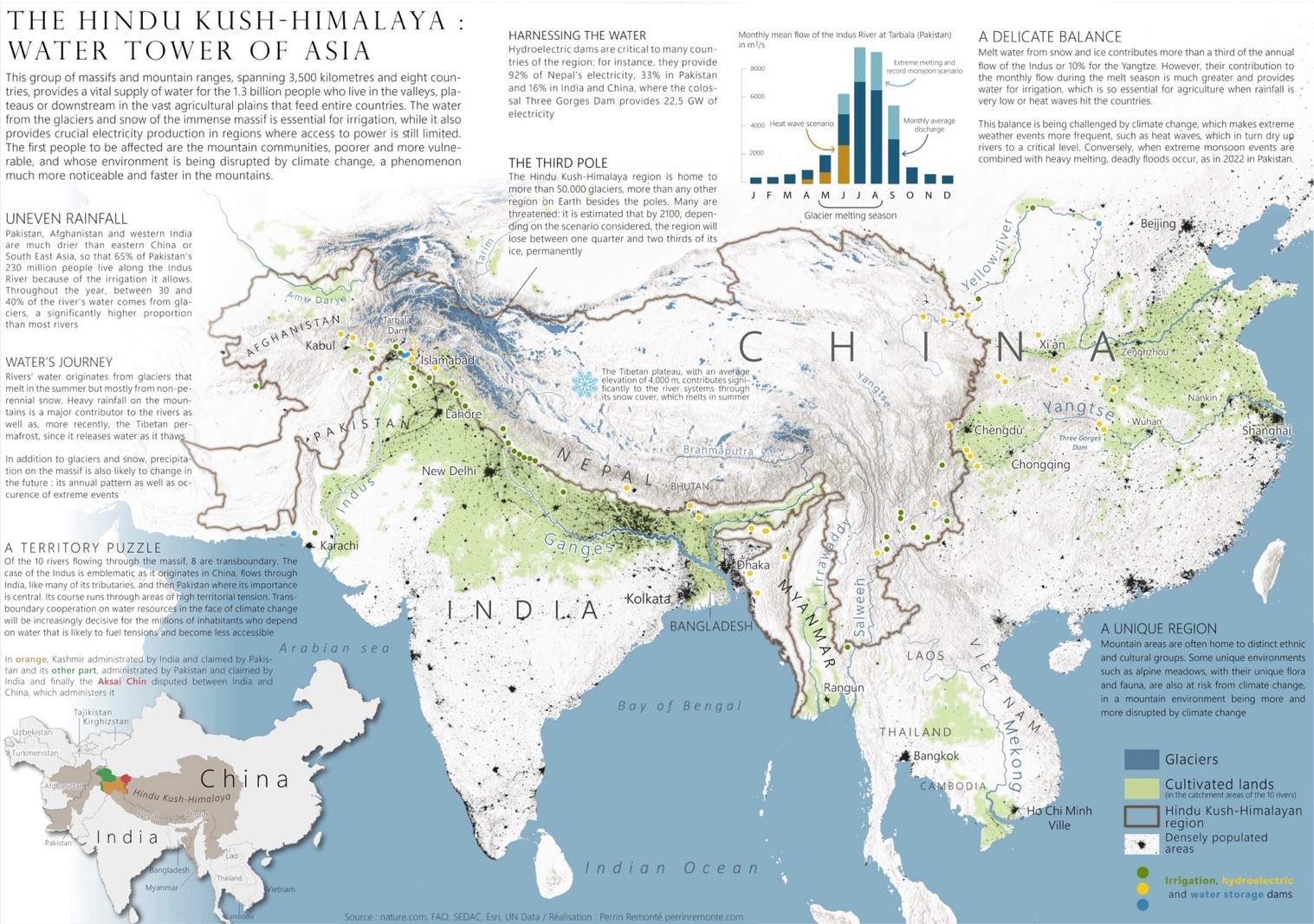
Hindu Kush Himalaya (HKH) spanning 4.2 million sq km across 9 countries |
|
Key Finding |
Snow persistence in 2024–2025 winter was 23.6% below 20-year average lowest in 23 years of satellite records |
|
Snow Persistence Definition |
The duration that snow remains on ground a key indicator for water availability |
|
Impact on River Basins |
All 12 major river basins showed deficits; Mekong (-51.9%), Salween (-48.3%) worst affected |
|
Major Indian River Basins Affected |
Ganga (-24.1%), Brahmaputra (-27.9%), Indus (-16.0%) |
|
Importance of Snowmelt |
Contributes 23% of annual river flow critical for irrigation, hydropower, drinking water |
|
Risks Identified |
Lower river runoff, increased groundwater dependency, higher drought risks |
|
Populations at Risk |
Over 2 billion people across South Asia |
|
Outlook |
Climate change continues to exacerbate vulnerability even under 1.5°C warming scenarios |
|
Category |
Details |
|
Geographical Extent |
Stretches ~3,500 km across 8 countries: Afghanistan, Bangladesh, Bhutan, China, India, Nepal, Myanmar, Pakistan |
|
Area Coverage |
Approx. 4.2 million sq.km |
|
Orientation |
Runs northeast to southwest; separates Amu Darya (Oxus) basin from Indus basin |
|
Geopolitical Intersection |
Borders converge near Pamir Knot (Afghanistan-China-Pakistan region) |
|
Major Sections |
Eastern HKH, Central HKH, Western HKH (Bābā Mountains) |
|
Prominent Peak |
Tirich Mir, 7,708 m (25,289 ft), Chitral, Pakistan |
|
Climatic Identity |
Known as “Third Pole” for its massive cryosphere; significant for global climate regulation |
|
Glacial Features |
Hosts ~54,000 glaciers & largest permanent ice cover outside poles |
|
Ecosystems |
Includes glaciers, alpine tundra, conifer forests, wetl&s, montane grassl&s |
|
Biodiversity Hotspots |
4 major ones Himalaya, Indo-Burma, Mountains of Central Asia & Mountains of Southwest China |
|
River Systems Originating |
10 major rivers Amu Darya, Indus, Ganges, Brahmaputra, Irrawaddy, Salween, Mekong, Yangtze, Yellow, Tarim |
|
Population Dependency |
Supports water needs of ~1.9 billion people across South, Central & East Asia |
|
Geological Formation |
Result of collision between Indian & Eurasian Plates (~55 million years ago) |
|
Tectonic Activity |
Highly active; associated with thrust faults, frequent earthquakes, orogenic uplift |
|
Permafrost Presence |
Widespread, though declining with warming; key hydrological buffer |
|
Snow Cover Dynamics |
Highly seasonal; critical for spring meltwater feeding rivers |
|
Hydrological Role |
Seasonal melt governs discharge in rivers like Ganga, Brahmaputra & Indus |
|
Environmental Threats |
Glacier retreat, permafrost thaw, flash floods, glacial lake outburst floods (GLOFs) |
|
Inner Valleys |
Arid with desert-like vegetation due to rain shadow effect |
|
Transboundary Nature |
Challenges in coordinated climate action, data sharing & river basin management |
|
Scientific Monitoring |
Tracked by institutions like ICIMOD, WMO & national meteorological agencies |
|
Policy Frameworks |
HKH Call to Action, Sustainable Development Goals (SDG 6, 13, 15), Paris Agreement alignment |
|
River Basin |
Origin in HKH |
Countries Benefited |
Length (approx.) |
Key Characteristics |
|
Amu Darya |
Pamir–Hindu Kush junction |
Afghanistan, Tajikistan, Turkmenistan, Uzbekistan |
~2,540 km |
Lifeline of Central Asia; historically Oxus River |
|
Indus |
Tibetan Plateau near Lake Manasarovar (via HKH ranges) |
China (Tibet), India, Pakistan |
~3,180 km |
Major irrigation source for Pakistan; high glacial dependency |
|
Ganges |
Gangotri Glacier (Indian Himalayas) |
India, Nepal, Bangladesh |
~2,525 km |
Supports densely populated Indo-Gangetic Plain |
|
Brahmaputra |
Chemayungdung Glacier (Tibet) |
China, India, Bhutan, Bangladesh |
~2,900 km |
Originates as Yarlung Tsangpo; extreme seasonal discharge |
|
Irrawaddy |
Eastern Himalayas |
Myanmar |
~2,170 km |
Main river of Myanmar; low glacial contribution |
|
Salween |
Tibetan Plateau |
China, Myanmar, Thail& |
~2,815 km |
Sparsely dammed, rich in biodiversity |
|
Mekong |
Eastern Himalayas |
China, Laos, Cambodia, Vietnam, Thail&, Myanmar |
~4,350 km |
Major Southeast Asian river; under threat from dams |
|
Yangtze |
Tanggula Mountains (adjacent to HKH) |
China |
~6,300 km |
Longest river in Asia; crucial for hydroelectricity |
|
Yellow River |
Bayan Har Mountains (northeast of HKH) |
China |
~5,464 km |
Prone to siltation & flooding |
|
Tarim |
Kunlun–Tianshan range (HKH influence) |
China |
~2,030 km |
Inl& river system, terminates in Taklamakan desert |
|
Feature |
Hindu Kush Himalaya (HKH) |
Andes |
Alps |
Rockies |
East African Highl&s |
|
Length |
~3,500 km |
~7,000 km |
~1,200 km |
~4,800 km |
~3,000 km |
|
Peak Elevation |
Tirich Mir (7,708 m) |
Aconcagua (6,961 m) |
Mont Blanc (4,808 m) |
Mount Elbert (4,401 m) |
Mount Kenya (5,199 m) |
|
Glacier Cover |
Largest outside polar regions |
Moderate |
Moderate |
Limited |
Limited |
|
River Source Significance |
10 major river systems |
Amazon tributaries, others |
Rhine, Rhône, Po |
Missouri, Colorado, Columbia |
Nile tributaries |
|
Tectonic Formation |
Collision of Indian & Eurasian plates |
Subduction of Nazca plate under South American |
African & Eurasian plate collision |
North American & Pacific plate interactions |
Rifting & volcanic activity |
|
Biodiversity Hotspots |
4 global hotspots |
Amazonian influence |
Alpine ecosystems |
Coniferous & montane |
Great Rift Valley hotspots |
|
Climatic Role |
Third Pole, snow-fed rivers, monsoon modulation |
Rain shadow, glacier-fed rivers |
Influences Western Europe |
Barrier to moist Pacific air |
Regulates rainfall in Rift Valley |
|
Human Dependency |
~1.9 billion people |
Localized populations, some megacities |
Densely populated valleys |
Western US & Canada |
Densely populated highl&s & rift valleys |
|
Feature |
Details |
|
Full Name |
International Centre for Integrated Mountain Development |
|
Established |
1983 |
|
Headquarters |
Kathm&u, Nepal |
|
Member Countries (8) |
Afghanistan, Bangladesh, Bhutan, China, India, Myanmar, Nepal, Pakistan |
|
Focus Region |
Hindu Kush Himalaya (HKH) |
|
Governance Structure |
Board of Governors (country representatives), Director General (executive head) |
|
Primary M&ate |
Promote sustainable mountain development through regional cooperation & scientific integration |
|
Core Thematic Areas |
Climate Change & Resilience |
|
Key Programs |
SERVIR-HKH (satellite data & GIS for environment) |
|
Research Contributions |
Glaciology, permafrost mapping, hydrology modelling, ecosystem valuation, air quality monitoring |
|
Notable Collaborations |
NASA, UNEP, UNDP, ADB, World Bank, national research institutes |
|
Strategic Tools |
Regional Database on Glaciers |
|
Role in Policy Influence |
Supports evidence-based policies on mountain issues in regional & global forums |
|
Disaster Risk & Resilience |
L&slide & flash flood risk monitoring; early warning systems |
|
Biodiversity Focus |
Monitoring protected areas, promoting sustainable tourism, conservation of endemic species |
|
Flagship Reports |
Hindu Kush Himalaya Assessment (2019), Water in HKH (2023), Cryosphere Monitoring Reports |
|
UN SDGs Alignment |
SDG 6 (Water), SDG 13 (Climate), SDG 15 (Ecosystems), SDG 17 (Partnerships) |
For more such articles, please visit IAS GYAN
Sources: TIMES OF INDIA
|
PRACTICE QUESTION Q. Hindu Kush Himalaya (HKH) is not only water tower of Asia but also a climate stabilizer & ecological hotspot. In this context critically examine transboundary environmental challenges facing HKH region & suggest a cooperative framework for sustainable development & climate resilience. |


© 2026 iasgyan. All right reserved


