Description
Copyright infringement not intended
Source: Deccan Herald
Context
The Geological Survey of India (GSI) has issued a warning about serious dangers to the Guryul Ravine fossil deposit in Kashmir due to continuous quarrying and land diversion.
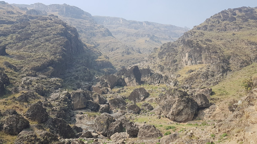
What Is Guryul Ravine?
- Guryul Ravine is a 260-million-year-old fossil-rich geological site, marking the Permian–Triassic boundary (PTB)—the period that witnessed Earth’s largest mass extinction.
- The site provides vital clues about ancient climate shifts, biodiversity collapse, and evolutionary recovery.
Where Is It Located?
The site lies in Khonmoh, on the outskirts of Srinagar, Jammu & Kashmir, and is geologically part of the Vihi District.
Formation of Guryul Ravine
- Guryul Ravine originated during the Permian–Triassic transition, a period marked by volcanic eruptions, falling oxygen levels, and drastic climatic upheavals that caused mass die-offs.
- Layers of marine and terrestrial sediments gradually preserved the fossil-bearing strata.
Key Features of Guryul Ravine
- Permian–Triassic Boundary Evidence:
Contains exceptional fossil records of the “Great Dying” that wiped out nearly 90% of marine species and 70% of terrestrial life.
- World’s Earliest Tsunami Record:
Geological layers reveal signs of Earth’s first known tsunami, adding to its scientific significance.
- Global Research Significance:
A hub for international geologists and researchers, attracting scientists from the USA, Japan, China, and other countries for field studies.
- Protected Fossil Zone:
Recognized as a notified fossil site by the Government in 2017, covering 9.8 lakh square meters for conservation.
- Scale Advantage Over Meishan, China:
Its 3-meter-thick boundary layer far surpasses China’s Meishan site (27 cm), making it one of the most substantial PTB fossil records globally.
What is the Permian–Triassic Extinction Event?
- It is also known as the End-Permian Extinction, or the 'Great Dying'.
- The Permian-Triassic extinction occurred around 251.9 million years ago, marking the boundary between the Permian and Triassic geological periods, as well as the Paleozoic and Mesozoic eras.
- It was one of the most severe extinction events the globe has ever seen, with biodiversity declining swiftly and across vast areas.
Source: Deccanherald.com
Practice Question:
Q. Consider the following statements about Guryul Ravine Fossil Site:
- It represents the Permian–Triassic boundary (PTB), linked to Earth’s largest mass extinction.
- The site is located near Srinagar in Jammu & Kashmir and is notified as a protected fossil zone.
- It contains the world’s first known tsunami record preserved in its geological layers.
- Its fossil-bearing boundary section is thinner than China’s Meishan site, making it less significant.
Which of the statements given above is/are correct?
A) 1 and 2 only
B) 1, 2 and 3 only
C) 1, 2 and 4 only
D) 1, 2, 3 and 4
Answer:
B) 1, 2 and 3 only
Explanation:
- Statement 1: Correct – Guryul Ravine marks the Permian–Triassic boundary, capturing Earth’s “Great Dying” event.
- Statement 2: Correct – It is situated near Khonmoh, Srinagar (J&K) and was declared a protected fossil zone in 2017.
- Statement 3: Correct – Geological layers here show the world’s earliest tsunami record.
- Statement 4: Incorrect – Guryul Ravine’s boundary section is 3 meters thick, which is much larger than China’s Meishan site (27 cm), making it more significant, not less.
|


