Description
Source: ForumIas
Disclaimer: Copyright infringement not intended.
Context
Vietnam's new Gulf of Tonkin baseline map prompts Chinese military exercises, intensifying maritime sovereignty disputes
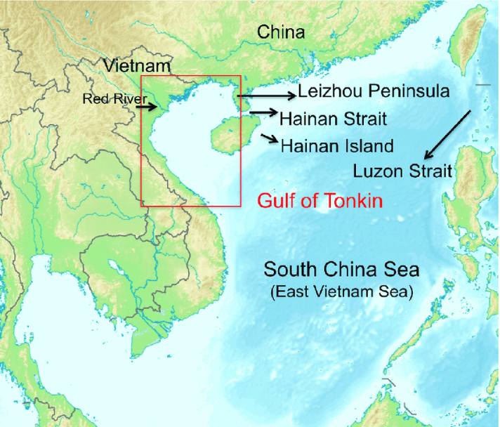
About Gulf of Tonkin
- It is a shallow, crescent-shaped semi-enclosed water body situated off South China and Northern Vietnam coasts in the South China Sea’s northwestern portion.
- It is located in the northwest part of the South China Sea.
- It is known as
- Beibu Gulf in Chinese
- Bac Bo Gulf in Vietnamese.
The gulf is bordered by the
- west and northwest - northern coast of Vietnam to the
- north - China’s Guangxi Zhuang Autonomous Region
- east - Leizhou Peninsula and Hainan Island
- It is connected with the South China Sea via the gulf’s mouth in the south and the Hainan Strait (Qiongzhou Strait) in the northeast
- The Gulf of Tonkin receives water from multiple rivers
- primarily the Red River
- Note - Red river is referred to as the Yuan River in China
-
- along with several smaller rivers along the northern and western coastal areas.
- In Northern Vietnam, the primary ports along the gulf are
- In China, the major port is Beihai or Pakhoi.
- The Gulf of Tonkin incident that took place in 1964 increased U.S. involvement in the Vietnam War.
- In Northern Vietnam, the gulf’s main ports include
- Haiphong and Ben Thuy
- In China, its major port is Beihai (Pakhoi).
Sources:
DD NEWS
|
PRACTICE QUESTION
Q.What recent action did Vietnam take regarding the Gulf of Tonkin?
A) Conducted live-fire military exercises
B) Published a baseline map defining its maritime claims
C) Signed a new maritime agreement with China
D) Established a joint fishing zone with neighboring countries
Answer: B) Published a baseline map defining its maritime claims
Explanation:
Vietnam released a map outlining a 14-point baseline in the Gulf of Tonkin to assert its maritime sovereignty, in line with UNCLOS and a 2000 agreement with China.
|


