Source: THE SUN
Disclaimer: Copyright infringement not intended.
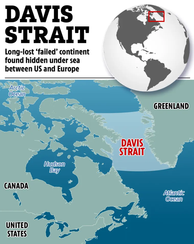
Scientists have discovered a submerged microcontinent off west coast of Greenland named Davis Strait Proto-Microcontinent formed between 49–58 million years ago due to tectonic evolution of strait between Greenland & Canada.
It is a newly discovered submerged microcontinent located in Davis Strait a large marine stretch between Canada Baffin Island & Greenland.
Named due to its formation being linked to tectonic evolution of Davis Strait.
The microcontinent is composed of thinned continental crust 19–24 km thick & is surrounded by two bands of thinner crust (15–17 km) that isolate it from Greenland & Baffin Island.
The discovery highlights a fragment of thick continental lithosphere now classified as a primitive proto-microcontinent.
Geological Context & Formation
The Davis Strait lies along boundary between North American & Greenland Plates.
The region experienced initial rifting ~118 Ma (Lower Cretaceous).
Seafloor spreading began around 61 Ma in Labrador Sea & Baffin Bay.
The microcontinent main formation occurred between ~49–58 Ma due to a shift in seafloor spreading direction along Pre-Ungava Transform Margin isolating crust.
Later Greenland collision with Ellesmere Island made it part of North American Plate.
Research & Definition
Defined by researchers (Longley, Phethean, Schiffer) as a proto-microcontinent i.e. a thick continental lithosphere segment isolated by thinner continental zones.
Research published in Gondwana Research.
Used plate tectonic reconstructions, gravity maps & seismic reflection data spanning ~30 million years to model its formation.
Key Facts about Davis Strait (Geographical Context)
The Davis Strait is a bay in northern Atlantic Ocean between southeastern Baffin Island (Canada) & southwestern Greenland.
It acts as a link between Baffin Bay (north) & Labrador Sea (south).
Forms part of Northwest Passage which connects Atlantic & Arctic Oceans through Canadian Arctic Archipelago.
Approximately 400 miles (650 km) long & 200 to 400 miles wide making it one of broadest straits in world.
The strait features complex underwater basins & ridges formed due to strike-slip faulting along Ungava Fault Zone (~45–62 Ma).
These tectonic activities triggered seafloor spreading in adjacent seas & contributed to emergence of Davis Strait proto-microcontinent.
|
Aspect |
Description |
|
Definition |
A microcontinent is a fragment of continental crust that is relatively small but not fully part of a major landmass. |
|
Formation |
Microcontinents form through tectonic processes such as rifting & plate movements that separate portions of continent. |
|
Tectonic Origin |
Typically formed at plate boundaries, either through rifting, subduction or collision which isolates fragments of continental crust. |
|
Size |
Smaller than regular continents but still large enough to be considered distinct from oceanic crust. |
|
Examples |
Davis Strait Proto-Microcontinent (offshore of West Greenland) |
|
Age |
Microcontinents can range from tens of millions to several hundred million years old depending on tectonic history of region. |
|
Crust Characteristics |
Often features thick continental crust surrounded by thinner oceanic crust. |
|
Significance in Plate Tectonics |
They provide evidence for past tectonic events such as continental break-up, rifting & oceanic crust formation. |
|
Potential for Mineral Resources |
Microcontinents often contain valuable mineral deposits particularly in areas of past volcanic activity. |
|
Impact on Seafloor Spreading |
Microcontinents may play a role in alteration of seafloor spreading patterns affecting ocean circulation & global tectonics. |
|
Key Studies |
Studies focus on movement & separation of these small landmasses & how they influence larger plate movements. |
|
Aspect |
Details |
|
Geological Timeframe |
~66 to 23 million years ago (Ma) |
|
Major Tectonic Plates |
North American, Eurasian, African, Indian, Pacific, Antarctic, South American, Australian |
|
Key Events |
Continued break-up of Gondwana |
|
North Atlantic Opening |
Seafloor spreading intensified between Greenland & North America; development of Davis Strait microcontinent |
|
Indian Plate Movement |
Indian Plate moved rapidly northwards (~15–20 cm/year), collided with Eurasian Plate (~55 Ma), initiating Himalayan orogeny |
|
Alpine Orogeny |
Formation of Alps, Carpathians, Zagros & related mountain systems due to Africa-Eurasia collision |
|
Pacific Plate Changes |
Subduction zones active along eastern Asia & western Americas |
|
South Atlantic Expansion |
Further rifting between South America & Africa; expansion of South Atlantic Ocean |
|
Transform Faulting |
Major transform faults such as San Andreas Fault began developing towards late Paleogene |
|
Greenland–Canada Rifting |
Formation of Davis Strait proto-microcontinent due to altered spreading direction along Pre-Ungava Transform (~49–58 Ma) |
|
Oceanic Changes |
Formation of deep ocean basins, rearrangement of global ocean currents, affecting global climate |
|
Volcanic Activity |
Intense volcanism in North Atlantic Igneous Province (NAIP); creation of flood basalts, dykes & sills |
|
Climate & Tectonics Link |
Tectonic reconfigurations changed ocean currents, triggering Paleocene-Eocene Thermal Maximum (PETM) ~56 Ma |
|
Significance |
Plate tectonics reshaped continents & ocean basins |
|
Continent / Region |
Tectonic Events during Paleogene (66–23 Ma) |
|
North America |
Opening of Labrador Sea & Baffin Bay |
|
South America |
Continued westward drift |
|
Europe |
Alpine Orogeny due to collision with African Plate |
|
Africa |
Northward movement |
|
Asia |
Collision of Indian Plate with Eurasia (~55 Ma) |
|
India |
Rapid northward drift (~15–20 cm/year) |
|
Australia |
Broke away from Antarctica |
|
Antarctica |
Separation from Australia & South America |
|
Greenland |
Partially rifted from North America |
|
Pacific Region |
Subduction along Ring of Fire intensified |
|
Aspect |
Cretaceous (145–66 Ma) |
Paleogene (66–23 Ma) |
|
Major Plate Movements |
- Breakup of Gondwana |
- Continued drift of continents |
|
Mountain Building |
Limited |
Major orogenies: Himalayas, Alps, Carpathians, Zagros |
|
Seafloor Spreading |
Active in Atlantic, Indian Ocean |
Continued in North Atlantic, Labrador Sea, Baffin Bay |
|
Greenland–Canada Rift |
Early stages of separation |
Formation of Davis Strait proto-microcontinent due to change in seafloor spreading orientation (~49–58 Ma) |
|
Climate Influence |
Greenhouse conditions dominated |
Initiation of cooling trend |
|
Volcanism |
Large igneous provinces like Deccan Traps (late Cretaceous) |
North Atlantic Igneous Province (NAIP) activity |
|
Ocean Currents |
Simple equatorial circulation |
More complex deep ocean currents began due to continental reorganization |
|
Significant Microcontinents |
Formation of some continental fragments (e.g., Greater Adria) |
Davis Strait proto-microcontinent formed between Greenland & Baffin Island |
For more such articles, please refer to IAS GYAN
Sources: WIONEWS
|
PRACTICE QUESTION Q. Discuss significance of discovery of Davis Strait proto-microcontinent in understanding Paleogene tectonics & continental evolution. |


© 2026 iasgyan. All right reserved


