India's coastline has been revised to 11,098.81 km from 7,561.60 km, an increase of 3,537.21 km, or approximately 50%.
Copyright infringement not intended
PC: Curious Stem
The Union Ministry of Home Affairs made a major announcement in December 2024 as part of its annual report for 2023-2024. It stated that the length of India's coastline has expanded from 7,516.6 km to 11,098.8 km, and that it is currently being reviewed.
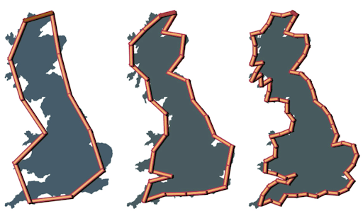
Coastlines have fractal-like features, with length increasing with decreasing measurement scales. Lewis Fry Richardson initially identified the Paradox, which was mathematically explained by Benoît Mandelbrot in 1967. Smaller units (for example, water molecules) may theoretically form an indefinitely long coastline.
|
Coastal Boundaries |
Bordered by the Bay of Bengal (East), Arabian Sea (West), and Indian Ocean (South). |
|
Coastal States |
Gujarat, Maharashtra, Goa, Karnataka, Kerala, Tamil Nadu, Andhra Pradesh, Odisha, West Bengal |
|
Coastal Union Territories |
Daman & Diu, Lakshadweep, Puducherry, Andaman & Nicobar Islands |
|
Coastline Paradox |
Identified by Lewis Fry Richardson in the 1950s; shows that coastal length changes with the scale of measurement due to the irregular shape of coastlines. |
|
Fractals |
Benoît Mandelbrot (1967) found that coastlines exhibit fractal-like properties, meaning they appear increasingly complex at smaller scales. |
|
Not True Fractals |
Coastlines are not pure mathematical fractals but share similar characteristics, complicating accurate measurement. |
|
Ruler Dependency |
The measured length depends on the size of the measuring unit (ruler). |
|
Example |
A 200-km ruler misses small features, while a 1-km ruler captures detailed curves, making the total coastline appear longer with smaller units. |
Source: The Hindu
|
Pratice Question: Q. Who coined the term "Coastline Paradox" and first identified the issue in measuring coastal length? A. Isaac Newton Answer: B. Lewis Fry Richardson |


© 2026 iasgyan. All right reserved


