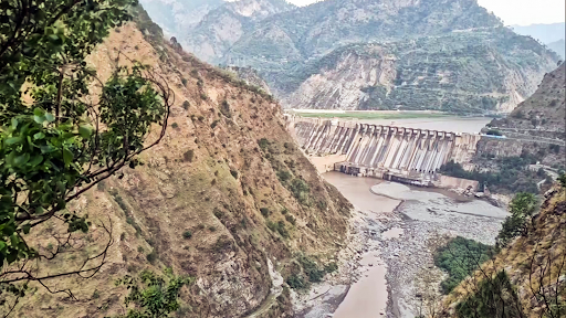
The Baglihar Dam, a major hydropower project on the Chenab, has previously been a hotspot in India-Pakistan tensions under the treaty.
Copyright infringement not intended
India reportedly opened many gates at the Baglihar Hydroelectric Power Project Dam, which is located on the Chenab River in Ramban.
|
Origin |
Formed by the confluence of the Chandra and Bhaga streams at Tandi, in the Lahaul and Spiti districts of Himachal Pradesh |
|
Upper Name |
Chandrabhaga (in its upper reaches) |
|
Initial Flow |
Flows west through the Jammu and Kashmir union territory |
|
Terrain Features |
Passes between the steep cliffs of the Siwalik Range (south) and the Lesser Himalayas (north) |
|
Flow Direction Change |
Turns southwest, entering Pakistan |
|
In Pakistan |
Descends into the alluvial lowlands of Punjab province |
|
Major Confluence |
Receives the Jhelum River near Trimmu |
|
Final Destination |
Empties into the Sutlej River, which is a tributary of the Indus River |
|
Location |
Ramban district, Jammu & Kashmir, on the Chenab River |
|
Type |
Run-of-the-river hydroelectric project with limited storage capacity |
|
Installed Capacity |
Approximately 900 MW (developed in two phases) |
|
Commissioned By |
NHPC Limited, with support from the Government of India |
|
Controversy |
Opposed by Pakistan for alleged violations of the Indus Waters Treaty (1960) |
|
Arbitration |
Subject to World Bank arbitration; ruling favored India with certain required technical modifications |
Source: Economic Times
|
Practice Question Q. Where is the Baglihar Hydroelectric Power Project located? (a) Jispa Correct Answer: (c) Ramban |


© 2026 iasgyan. All right reserved


