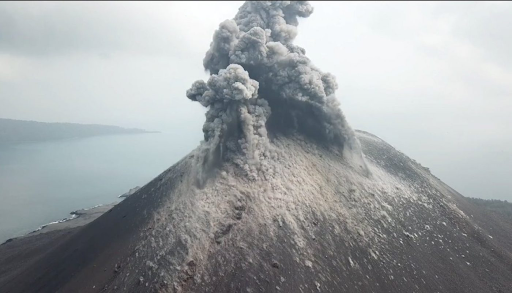
The Indonesian island of Anak Krakatau is a volcanic formation. Anak Krakatau initially surfaced from the caldera created in 1883 by the enormous volcanic eruption that obliterated the island of Krakatoa on December 29, 1927.
Copyright Infringement not Intended
Pic Courtesy: msn.com
A new study suggests that Indonesia's Anak Krakatau volcano, which fell catastrophically in 2018 and caused a horrific tsunami, had warning indications years in advance.
|
Feature |
Details |
|
Location |
Sunda Strait, between Java and Sumatra, Indonesia. |
|
Volcano Type |
Stratovolcano. |
|
Tectonic Context |
At the convergent boundary between the Indo-Australian and Eurasian plates; part of the Pacific Ring of Fire. |
|
2018 Disaster |
Southwest flank collapsed during an eruption in December 2018, causing a tsunami that killed over 400 people and injured thousands. |
|
Technology Used (Research) |
InSAR (Interferometric Synthetic Aperture Radar) – detects surface deformation with cm to mm accuracy. |
|
Satellite Sources |
ALOS-1, COSMO-SkyMED, Sentinel-1; data spanned over 10+ years. |
|
Key Findings |
The volcano’s flank slipped ~15 meters between 2006 and 2018; significant acceleration of slip noted in the months before the 2018 collapse (precursor to the disaster). |
|
Practice Questions: Q. Anak Krakatau, an active volcanic island, is located in which of the following straits? [B] Sunda Strait [C] Lombok Strait [D] Makassar Strait Answer: B Explanation: Anak Krakatau, meaning “Child of Krakatoa,” is situated in the Sunda Strait, which lies between the Indonesian islands of Java and Sumatra. |


© 2026 iasgyan. All right reserved


