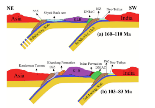
Scientists decoded 130 million years of Ladakh Magmatic Arc history, mapping Neo-Tethys subduction through three phases. This research aids critical mineral discovery, geothermal energy at Puga Valley, and seismic hazard preparedness for the Indo-Gangetic plains.
Copyright infringement not intended
Picture Courtesy: PIB
Scientists from the Wadia Institute of Himalayan Geology (WIHG) decoded the 130-million-year-old evolutionary history of the Ladakh Magmatic Arc (LMA) in the North-Western Himalaya.
It is a belt of igneous rocks (formed from cooled magma or lava) located in the Trans-Himalayan region.
It was formed over a long period from the Jurassic to the Eocene epoch (approximately 201.3 to 33.9 million years ago). Before the Himalayas rose, this region was part of the Neo-Tethys Ocean.
Mechanism of Formation: The LMA was formed by the continuous northward subduction (a process where one tectonic plate moves under another) of the Neo-Tethyan oceanic plate beneath the Eurasian continental plate.
Geochemical Analysis: Scientists used isotopes of elements like Strontium (Sr) and Neodymium (Nd) as "geological time machines."
The Three Phases of LMA's Tectonic Evolution
Phase 1: Pre-Collisional Island Arc (160–110 Million Years Ago)
Phase 2: Pre- to Syn-Collisional Maturation (103–45 Million Years Ago)
Phase 3: Post-Collisional Fracturing (< 45 Million Years Ago)
Strategic Significance
Critical Mineral Exploration
Mapping the LMA’s geology identifies potential deposits of copper, gold, and molybdenum, directly supporting the National Critical Minerals Strategy 2024 for self-reliance in green technology.
Geothermal Energy Potential
The residual heat from ancient tectonic activity makes Ladakh a prime location for geothermal energy.
Seismic Hazard Preparedness
Mapping the Ladakh Magmatic Arc's deep faults helps seismologists predict tectonic stress and improve earthquake preparedness for millions in high-risk zones.
Expand Deep Earth Exploration
Accelerate initiatives like the 'Deep Ocean Mission' and expand the National Geoscience Data Repository (NGDR) to include high-resolution isotopic data from the LMA.
Implement Sustainable Mining Frameworks
Any future mineral exploration in Ladakh must be governed by strict Environmental Impact Assessments (EIAs) tailored to its fragile ecosystem, drawing lessons from Supreme Court rulings like the T.N. Godavarman case.
Strengthen Cross-Border Collaboration
Use platforms like the Shanghai Cooperation Organisation (SCO) to initiate collaborative geoscientific research with neighboring countries to improve regional disaster risk reduction.
Understanding the Ladakh Magmatic Arc provides a strategic roadmap for India to secure critical minerals, harness geothermal energy, and build seismic resilience, integrating deep-time geological insights into a sustainable and secure future for the Himalayan region.
Source: PIB
|
PRACTICE QUESTION Q. Consider the following statements regarding the Ladakh Magmatic Arc (LMA): 1. It was formed by the continuous northward subduction of the Indian continental plate beneath the Eurasian plate. 2. The rocks of the Dras-Nidar Island Arc Complex (DNIAC) are associated with the pre-collisional phase of the LMA's evolution. Which of the statements given above is/are correct? a) 1 only b) 2 only c) Both 1 and 2 d) Neither 1 nor 2 Answer: b Explanation: Statement 1 is incorrect: The Ladakh Magmatic Arc (LMA) was formed by the northward subduction of the Neo-Tethyan oceanic plate beneath the Eurasian plate, not the subduction of the Indian continental plate. Statement 2 is correct: The Dras-Nidar Island Arc Complex (DNIAC) represents the earliest, pre-collisional phase of the LMA's evolution. |
The Ladakh Magmatic Arc (LMA) is an extensive belt of igneous rocks located in the Trans-Himalaya region. It was formed over tens of millions of years (from the Jurassic to the Eocene epoch) due to immense geological and volcanic activity caused by the shifting of tectonic plates.
Before the Himalayas existed, the region was covered by the Neo-Tethys Ocean. The LMA was created by a process called subduction, where the Neo-Tethyan oceanic plate plunged into the Earth's mantle beneath the Eurasian continental margin. This intense process melted the crust and generated massive amounts of magma, forming the arc over three distinct geological phases.
The Neo-Tethys Ocean was a vast, ancient body of water that existed between the Indian and Eurasian tectonic plates before they collided. As the Indian plate drifted northward, this ocean was subducted (pushed down) into the Earth's mantle, eventually closing completely to give rise to the Himalayan mountain range.


© 2026 iasgyan. All right reserved