An ISRO study on the August 2025 Dharali flash flood identifies the collapse of exposed ice patches in nivation hollows—driven by rapid deglaciation and global warming—as a critical new cryospheric hazard, necessitating that India’s NDMA expand its satellite surveillance and early warning systems beyond traditional GLOF monitoring to protect high-altitude regions.
Copyright infringement not intended
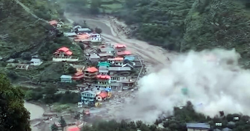
Picture Courtesy: THEHINDU
Context
A recent study on the Dharali village flash flood (Uttarakhand, August 2025) by the Indian Space Research Organisation (ISRO) has identified a new and dangerous cryo-hydrological hazard.
What are the key Findings of the Study?
A collapse of an exposed ice patch in a 'nivation' area, rather than a traditional Glacial Lake Outburst Flood (GLOF), caused the flood. This highlights a previously overlooked threat linked to rapid Himalayan deglaciation.
The Collapse is driven by:
Nivation
It is a localized erosion process where repeated freeze-thaw cycles beneath snowbanks carve out depressions known as nivation hollows.
Protective Role of Firn
In healthy glaciers, a protective layer of firn and seasonal snow acts as insulation, shielding the underlying ice from atmospheric temperature fluctuations and preventing rapid melting.
The Collapse Trigger
Rising temperatures during the melting season strip away protective snow layers, leaving exposed ice patches to react instantly to heat and rain, causing rapid fragmentation and sudden collapses that trigger violent debris-laden flash floods.
What is the nature of the escalating threat in the Himalayas?
The Dharali incident signals a systemic risk driven by accelerating climate change, moving beyond the traditionally monitored Glacial Lake Outburst Floods (GLOFs).
Accelerated Deglaciation
Glaciers in the Hindu Kush Himalaya (HKH) region disappeared 65% faster in the 2011–2020 decade compared to the previous one. Projections indicate a potential loss of up to 80% of glacier volume by 2100 under current emission scenarios. (Source: ICIMOD HI-WISE Report)
Global Ice Loss
The period from 2022 to 2024 saw the largest three-year loss of glacier mass on record globally, confirming a worsening trend. (Source: WMO State of the Global Climate Report)
Expanding the Hazard Matrix
While disaster management historically prioritizes GLOFs, the collapse of unstable ice patches in nivation hollows represents an equally destructive but under-monitored "transitional state" of glacial retreat
What are the potential impacts?
Sudden cryospheric failures cause severe cascading impacts downstream, devastating both local populations and critical infrastructure.
Key Case Studies of Disasters
|
Event |
Cause |
Impact |
Key Learning |
|
Chamoli Disaster, Uttarakhand (2021) |
Massive rock-ice avalanche from Nanda Devi glacier. |
Destroyed Rishiganga dam, damaged Tapovan Vishnugad plant, and caused over 200 deaths (Source: NDMA) |
Demonstrated the catastrophic potential of non-GLOF cryospheric failures on downstream infrastructure. |
|
Sikkim GLOF (2023) |
Outburst of South Lhonak glacial lake. |
Washed away the 1,200 MW Teesta Stage III dam, causing massive economic and structural damage. (Source: CWC Report) |
Highlighted the vulnerability of large-scale infrastructure to sudden, high-volume meltwater surges. |
|
Dharali Flash Flood, Uttarakhand (2025) |
Collapse of an exposed ice patch in a nivation hollow. |
Swept away houses and resulted in six fatalities in a village located at a river confluence. (Source: NPJ Natural Hazards). |
Revealed ice-patch collapse as a distinct, lethal hazard requiring urgent attention and new monitoring protocols. |
Threat to Regional Water Security
Glacier collapse and rapid melting disrupt stable water supplies, causing flash floods and chronic seasonal droughts, threatening water and food security for millions in India and Pakistan.
Mitigation and The Way Forward
Mandate Pre-Event Satellite Surveillance
The ISRO study confirms that high-resolution satellite imagery can identify exposed ice patches before they fail. High-resolution satellite data must be used to map nivation hollows as a standard procedure.
Update NDMA Guidelines
The National Disaster Management Authority's (NDMA) National Glacial Lake Outburst Floods Risk Mitigation Programme (NGRMP) must be expanded to include the mapping and monitoring of "geomorphologically sensitive nivation zones" and other unstable ice surfaces.
Adopt Global Best Practices: India can learn from international models:
Enforce Strict Land Use Planning
To prevent settlement expansion into vulnerable areas, state governments must enforce NDMA construction prohibitions in high-risk zones using Digital Elevation Models (DEM) to map potential flood paths from all glaciated peaks.
Conclusion
The Dharali flash flood signals an urgent need for India to shift from reactive responses to predictive monitoring by institutionalizing satellite surveillance of nivation zones and updating national risk frameworks to mitigate the growing threat of exposed ice patch collapses.
Source: THEHINDU
|
PRACTICE QUESTION Q. Which of the following best describes 'Nivation', a process recently highlighted in the context of Himalayan flash floods? A) The rapid advancement of a glacier due to heavy seasonal snowfall. B) Localized ground erosion beneath snowbanks caused by repeated freeze-thaw cycles. C) The chemical weathering of limestone specifically in high-altitude permafrost. D) The sudden drainage of a moraine-dammed lake into a downstream valley. Answer: B Explanation: The process of Nivation, recently highlighted in the context of Himalayan flash floods (such as the 2025 Dharali incident), is defined as the localized ground erosion beneath snowbanks caused by repeated freeze-thaw cycles. |
Nivation is the localized erosion of the ground beneath and around a snowbank. It is primarily driven by alternate freezing and thawing cycles, eventually carving out topographical depressions known as 'nivation hollows'.
Firn is an intermediate state between freshly fallen snow and fully compressed solid glacial ice. It acts as a natural insulating layer over the ice beneath it, protecting it from short-term atmospheric temperature spikes and heavy rainfall.
A flash flood is a rapid, intense flooding event that occurs within six hours—and often within three hours—of heavy rainfall, dam failures, or ice jams. Unlike regular floods, which develop slowly over days, flash floods happen almost instantly, leaving little time for warning. They are characterized by fast-moving, high-volume water that can sweep away cars and destroy buildings.


© 2026 iasgyan. All right reserved