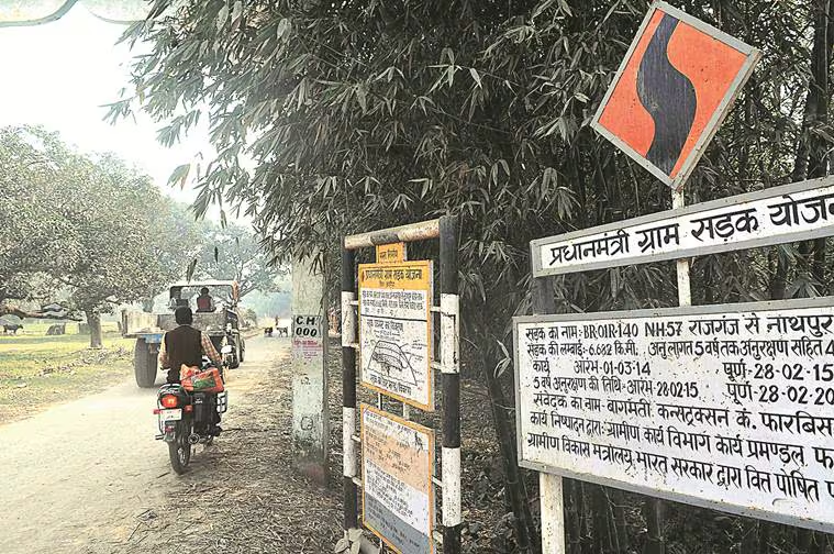
The Union Government has directed states to add QR codes on PMGSY road maintenance boards. These codes link to the eMARG system, letting residents upload geo‑tagged photos and flag road issues. Integrated with AI‑enhanced inspection and performance evaluation, this enables real‑time public feedback, boosting transparency and accountability in rural road maintenance.
Copyright infringement not intended
Picture Courtesy: INDIAN EXPRESS
The Union Government is introducing QR codes for roads constructed under the Pradhan Mantri Gram Sadak Yojana (PMGSY).
It is an initiative launched in 2000, by the Union Ministry of Rural Development (MoRD), to provide all-weather road connectivity to eligible unconnected habitations in rural areas.
It aims to connect habitations with population size 500+ in plains, 250+ in northeastern and hill states/UTs, special category areas (Tribal Schedule V, Aspirational Districts/Blocks, Desert areas) and 100+ in LWE-affected areas (notified by the Ministry of Home Affairs in nine states), as per Census 2011.
Phases of Implementation
Initially a Centrally Sponsored Scheme, the funding pattern was changed in 2015-16 to a 60:40 ratio between the Centre and states. For northeastern and Himalayan states, the ratio is 90:10.
As per data available on the scheme dashboard => Since the scheme was launched, a total road length of 8,36,850 km has been sanctioned, of which 7,81,209 km has been completed.
The Union Ministry of Rural Development, through its technical arm, the National Rural Infrastructure Development Agency (NRIDA), has directed states to implement the QR code system.
How the New System Works?
QR Code Generation => A unique QR code is generated for each road through the e-MARG portal.
Public Accessibility => This QR code is displayed on the maintenance information board at the start of the road, with instructions in both English and the local language.
Citizen Feedback Mechanism => Any citizen can scan the QR code with a smartphone. This provides details about the road, including its length, contractor details, and maintenance plan. Users can then flag issues by uploading geo-tagged photographs and comments directly through a feedback window.
Integration with Official Inspections => The feedback and photographs submitted by citizens are integrated with the routine inspections carried out by field engineers.
Use of Modern Technology => Artificial Intelligence (AI) and Machine Learning (ML) will be used to analyze the photographs to assist in the Performance Evaluation (PE) of the contractor's maintenance work.
Must Read Articles:
Pradhan Mantri Gram Sadak Yojna
Source:
|
PRACTICE QUESTION Q. Consider the following statements regarding the Pradhan Mantri Gram Sadak Yojana (PMGSY): 1. PMGSY was launched as a Centrally Sponsored Scheme. 2. The scheme's purview is strictly limited to rural areas, and it does not cover the construction of urban roads. 3. It is a poverty reduction strategy that operates by creating rural infrastructure. How many of the above statements are correct? A) Only one B) Only two C) All three D) None Answer: C Explanation: Statement 1 is correct: The Pradhan Mantri Gram Sadak Yojana was launched in 2000, as a Centrally Sponsored Scheme. Later, the funding pattern was revised to a 60:40 split between the Centre and States (90:10 for North-Eastern and Himalayan States). Statement 2 is correct: The program's sole mandate is to provide all-weather road connectivity to eligible unconnected habitations in India's rural areas. Statement 3 is correct: The PMGSY is a poverty reduction strategy that operates by creating rural infrastructure. The core idea is that providing all-weather road connectivity will improve the socio-economic conditions of the rural population by giving them better access to markets for their agricultural produce, as well as essential services like healthcare and education. |


© 2026 iasgyan. All right reserved