Description
Copyright infringement not intended
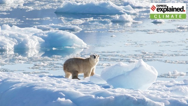
Picture Courtesy: The Indian Express
Context:
In his address at the United Nations General Assembly US President Donald Trump claimed that climate change predictions were “wrong” and dismissed them as misleading.
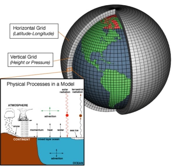
What are Climate Models?
A climate model is a computer-based simulation that represents how the Earth’s climate system functions — including the atmosphere, oceans, land, and ice.
These models are built on the principles of physics, chemistry, and biology and are used to analyze how different factors — such as greenhouse gas emissions or land-use changes — influence temperature, rainfall, and weather events.
How do Climate Models work?
- Modern climate models divide the Earth into a three-dimensional grid, consisting of small “cells” that represent sections of land, air, or water.
- Each cell uses mathematical equations to describe how energy and matter move within it and how they interact with neighboring cells.
- Scientists input real-world data — such as CO₂ levels, ocean temperatures, and wind patterns — into these models to simulate future conditions.
- The output provides insights into temperature and rainfall trends, sea-level rise, ice melt, and extreme weather frequency.
Copyright infringement not intended
Picture Courtesy: The Indian Express
Current status of Climate Models in India:
- India has two top supercomputers for climate/weather work: Pratyush (IITM, Pune) with ~4 petaflops and Mihir (NCMRWF, Noida) with ~2.8 petaflops. (Source: The Economics Times)
- In May 2025, the Bharat Forecast System (BFS) was launched. It’s an indigenous model with 6-km grid resolution, improving accuracy and local predictions. (Source: TOI)
- Cyclone landfall predictions (within a 48-hour window) have improved by up to 65%. (Source: The Print)
- Forecasts of heavy rainfall, fog, and heatwaves have improved by about 40% over the past five years. (Source: The Print)
Evolution of Climate Models:
|
Stage / Model Type
|
Time Period
|
Main Features
|
Purpose / Contribution
|
|
Energy Balance Models (EBMs)
|
1960s
|
Basic models using energy input from the Sun and heat loss to space
|
Calculated average global surface temperature; studied basic warming trends
|
|
Radiative Convective Models (RCMs)
|
1970s
|
Added vertical layers of the atmosphere; simulated energy movement up and down
|
Helped estimate temperature variation with altitude; improved atmospheric understanding
|
|
General Circulation Models (GCMs)
|
1980s onward
|
Simulated atmosphere, oceans, land, and ice using physics-based equations
|
Predicted large-scale climate changes like global temperature rise, rainfall, and sea-level changes
|
|
Earth System Models (ESMs)
|
2000s onward
|
Integrated biological, chemical, and human factors like carbon cycles and emissions
|
Showed how natural systems and human activities interact in the climate system
|
|
Regional Climate Models (RCMs)
|
Present day
|
Focused on specific countries or regions; refined global data for local accuracy
|
Provided localized climate forecasts for agriculture, water, and disaster management
|
Issues with Climate Models:
- Data Limitations: Many regions, especially in developing countries, lack accurate and continuous weather data. According to the World Meteorological Organization (WMO, 2024), around 60% of African weather stations and 45% of South Asian stations are either non-functional or lack regular data uploads. (Source: WMO)
- Limited Regional Accuracy: Models often divide the Earth into large grid cells (100–250 km wide). This makes them less capable of predicting local weather patterns, such as monsoon variations, urban flooding, or regional droughts. During the 2023 Himachal Pradesh floods, models underestimated rainfall intensity by 25–30%, according to the India Meteorological Department (IMD). (Source: IMD)
- Uncertainty in Complex Processes: Natural events like volcanic eruptions, cloud formation, or El Niño are hard to simulate precisely. Models predicted the 2015–16 El Niño would cause global temperatures to rise by 0.5°C, but the actual increase was 72°C, showing sensitivity errors. (Source: IPCC Sixth Assessment Report, 2023)
- Dependence on Assumptions: Models use assumptions about future greenhouse gas emissions, population growth, and technology use. Under Representative Concentration Pathways (RCPs) 4.5, models projected a 4°C rise by 2100, but under the high-emission RCP 8.5, the same models show a 4.3°C rise (Source: Down to Earth)
- Calibration Bias: Most models were developed and tested in North America and Europe, where better data exists. The IMD reported that global models overestimate India’s pre-monsoon rainfall by up to 40% due to calibration issues (Source: IMD)
Government measures to improve climate models:
- Ministry of Earth Sciences (MoES) set up: ‘Pratyush’ (Pune) and ‘Mihir’ (Noida) supercomputers, with a combined capacity of 8 petaflops, among the world’s top climate research systems. Forecast accuracy for extreme weather events improved from 60% in 2015 to 74% in 2024, according to IMD.
- IITM Pune runs India’s Earth System Model (IITM-ESM) for studying long-term climate changes, such as monsoon variability and global warming impacts.
- Coordinated Regional Climate Downscaling Experiment (CORDEX) – South Asia: India participates in CORDEX, an international initiative led by the World Climate Research Programme (WCRP). The project creates high-resolution regional climate models (RCMs) tailored for South Asia, improving forecasts for local weather and monsoons.
- National Monsoon Mission (NMM): Launched in 2012 by MoES to enhance predictive capability of the Indian monsoon using advanced dynamical models. Monsoon prediction skill scores have increased from 22 (2012) to 0.45 (2024) on a scale of 0–1.
- India collaborates with WMO, IPCC, and CMIP for sharing climate data and improving model Data from Indian satellites like INSAT-3D and SCATSAT-1 are used globally to refine climate projections.
Way Forward:
- Expand ground-based weather stations, automatic rain gauges, and ocean buoys—especially in under-monitored regions like central India and the Himalayas. India currently has around 7,000 weather stations, but experts suggest it needs 15,000+ for finer local modeling. (Source: The Hindu)
- Invest in next-generation supercomputers beyond Pratyush and Mihir to handle high-resolution Earth System Models.
- Create more India-specific regional climate models (RCMs) to predict monsoon variability, floods, and droughts with greater accuracy. AI-based hybrid models have improved cyclone track prediction accuracy by up to 30%, as per MoES (2024).
- Include human factors such as urbanization, deforestation, and energy use into models for more realistic outcomes. Real-time climate advisories are already helping over 6 million farmers under the Gramin Krishi Mausam Sewa (GKMS) (Source: PIB)
- Strengthen partnerships between IMD, IITM, ISRO, DST, and universities for data sharing and model development. Collaborative models under CORDEX-South Asia improved monsoon simulation accuracy by 25%.
- Train young researchers, meteorologists, and data scientists in climate modeling, big data analysis, and AI applications.
Source: Indian Express
|
Practice Question
Q. Climate models are essential but not infallible.” Discuss the limitations of climate models with relevant data. (250 words)
|
Frequently Asked Questions (FAQs)
A climate model is a computer-based simulation that uses physics, chemistry, and biology to study how the Earth’s climate works. It helps predict temperature, rainfall, sea-level rise, and other changes under different greenhouse gas scenarios.
They divide the Earth into 3D grid cells (covering land, oceans, and atmosphere). Mathematical equations calculate how energy, gases, and moisture move between these cells, helping scientists understand climate patterns and predict future changes.
- Incomplete or poor-quality regional data
- Coarse grid size (100–250 km) limiting local accuracy
- Difficulty in simulating complex natural processes (like clouds or monsoons)
- Dependence on future assumptions about emissions and human activity