Description
Disclaimer: Copyright infringement not intended.
Context
- Government said, India’s satellite-based navigation system, NavIC, is as good as GPS of the United States in terms of position accuracy and availability in its service region.
NaviC
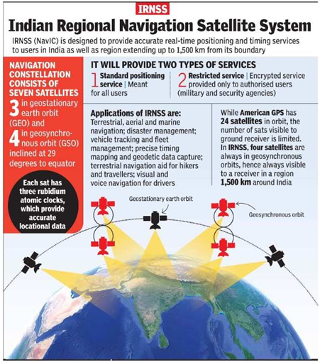
- NavIC (Navigation with Indian Constellation) is an autonomous regional satellite navigation system established and maintained by ISRO.
Coverage
- It covers India and a region extending up to 1,500 km beyond Indian mainland (primary coverage area) with plans of extension.
- An extended service area lies between the primary service area and a rectangle area enclosed by the 30th parallel south to the 50th parallel north and the 30th meridian east to the 130th meridian east.
Satellites
- The system currently consists of a constellation of seven satellites, with two additional satellites on ground as stand-by.
- Three of the seven satellites in constellation are located in geostationary orbit (GEO) and four in inclined geosynchronous orbit (IGSO).
Accuracy
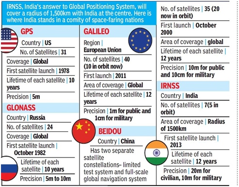
- The system is intended to provide an absolute position accuracy of better than 10 metres throughout Indian landmass and better than 20 metres in the Indian Ocean.
- In short, it provides position accuracy better than 20 m and timing accuracy better than 50 nanoseconds(20).
Applications
- NavIC will provide two levels of service, the "standard positioning service", which will be open for civilian use, and a "restricted service" (an encrypted one) for authorised users (including the military).
- NavIC based applications are being used in various civilian sectors, including, transport, map applications, and timekeeping.
- NavIC based trackers are compulsory on commercial vehicles in India.
- Today major mobile chipset manufacturers like Qualcomm, MediaTek and Broadcom already support NavIC across various chipset platforms.
- NavlC is an indigenous positioning system that is under Indian control.
- There is no risk of the service being withdrawn or denied in a given situation.

GPS VS NAVIC
- The GPS, has a position accuracy of 20–30 m.
- Unlike GPS which is dependent only on L-band, NavIC has dual frequency (S and L band frequencies).
- When low frequency signal travels through atmosphere, its velocity changes due to atmospheric disturbances.
- US banks on atmospheric model to assess frequency error and it has to update this model from time to time to assess the exact error.
- In India's case, the actual delay is assessed by measuring the difference in delay of dual frequency (S and L bands).
- Therefore, NavIC is not dependent on any model to find the frequency error and is more accurate than GPS.
About Frequency Bands
L Band
- The L band is the Institute of Electrical and Electronics Engineers (IEEE) designation for the range of frequencies in the radio spectrum from 1 to 2 gigahertz (GHz).
Applications
- Mobile service
- Satellite navigation
- Telecommunications use
- Aircraft surveillance
- Amateur radio
- Digital audio, Video, multimedia broadcasting
- Astronomy
Advantages of L Band Frequency over other frequency bands:
- This frequecy band faces less interference from heavy rain fading.
- The low frequency range makes it easier to design and source components.
- The components for this band are less expensive than those for higher frequency bands.
S band
- The S band is a designation by the Institute of Electrical and Electronics Engineers (IEEE) for a part of the microwave band of the electromagnetic spectrum covering frequencies from 2 to 4 gigahertz (GHz).
Applications
- The S band is used by airport surveillance radar for air traffic control, weather radar, surface ship radar, and some communications satellites, especially those used by NASA to communicate with the Space Shuttle and the International Space Station.
- The largest use of this band is by WiFi networks.
- The S band can also be used for issuing distress signals in accident situations and for delivering real-time data and status for traffic and weather conditions.
- In some countries, S band is used for Direct-to-Home satellite television.
- IndoStar-1 was the world's first commercial communications satellite to use S-band frequencies for broadcast.
https://www.pib.gov.in/PressReleasePage.aspx?PRID=1848313