India’s IRNSS is now part of World Wide Radio Navigation System

Last Updated on 21st November, 2020
1 minute, 11 seconds

Description

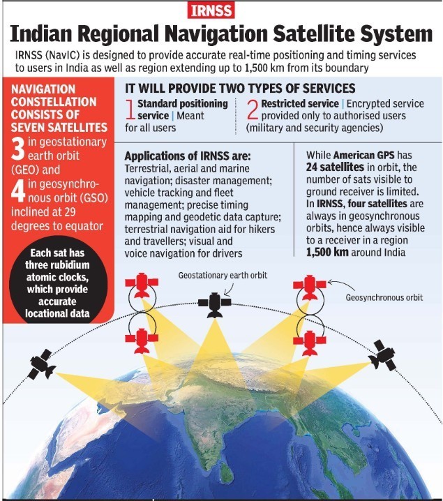
Context: The Indian Regional Navigation Satellite System (IRNSS) has been accepted as a component of the World Wide Radio Navigation System (WWRNS) for operation in the Indian Ocean Region by the International Maritime Organization (IMO).

  • This will position information similar to GPS and GLONASS to assist in the navigation of ships in ocean waters within the area covered by 50°N latitude, 55°E longitude, 5°S latitude and 110°E longitude (approximately up to 1500 km from Indian boundary).
  • It is a significant achievement of Ministry of Ports, Shipping and Waterways (MoPSW) and Indian Space Research Organisation (ISRO) towards “Atmanirbhar Bharat”.

IRNSS

  • IRNSS is an independent regional navigation satellite system developed by India.
  • It is designed to provide accurate position information service to assist in the navigation of ships in Indian Ocean waters.

https://www.pib.gov.in/PressReleasePage.aspx?PRID=1674483

Related Articles

Pi 22 Mar, 2025
AUDIBLE ENCLAVES 22 Mar, 2025
NEURAL NETWORK 21 Mar, 2025
PARCABADMIDE 19 Mar, 2025
WATER ON MOON 19 Mar, 2025
MELIOIDOSIS 19 Mar, 2025

Free access to e-paper and WhatsApp updates

Let's Get In Touch!