Description
Disclaimer: Copyright infringement not intended.
Context
- India rejected China’s renaming of several places in Arunachal Pradesh, saying “invented names” will not affect the status of Indian sovereignty over the region.
Details
- These places include two land areas, two residential areas, five mountain peaks and two rivers.
- It also listed the category of places’ names and their subordinate administrative districts.
India’s response
- India rejected this outright. India said that Arunachal Pradesh is, has been, and will always be an integral and inalienable part of India.
- This is the third time that China has attempted to rename parts of Arunachal Pradesh.
- In 2017, China’s Ministry of Civil Aviation issued a similar list of six places, and in 2021, released a list of 15 renamed places it sought to rename.
.jpeg)
What is China’s claim on Arunachal Pradesh?
- China claims some 90,000 sq km of Arunachal Pradesh as its territory.
- It calls the area “Zangnan” in the Chinese language and makes repeated references to “South Tibet”.
- Chinese maps show Arunachal Pradesh as part of China, and sometimes parenthetically refer to it as “so-called Arunachal Pradesh”.
- China makes periodic efforts to underline this unilateral claim to Indian territory. Giving Chinese names to places in Arunachal Pradesh is part of that effort.
What is China’s argument for claiming these areas?
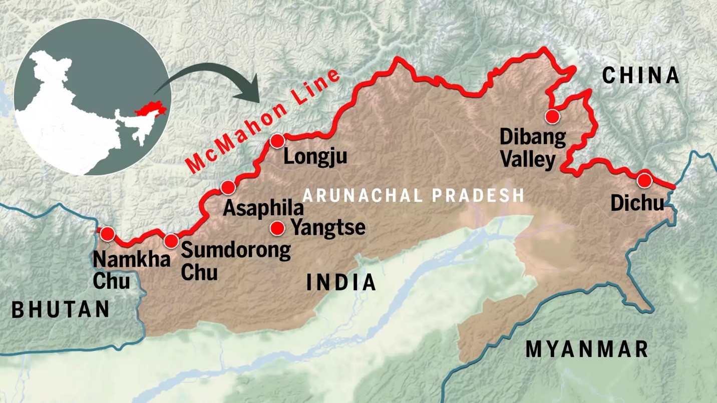
- The People’s Republic of China disputes the legal status of the McMahon Line, the boundary between Tibet and British India that was agreed at the Simla Convention — officially the ‘Convention Between Great Britain, China, and Tibet’ — of 1914.
- China was represented by a plenipotentiary of the Republic of China.
- The Chinese representative did not consent to the Simla Convention, saying Tibet had no independent authority to enter into international agreements.
- The McMohan Line, named after Henry McMahon, the chief British negotiator at Shimla, was drawn from the eastern border of Bhutan to the Isu Razi pass on the China-Myanmar border.
- China claims territory to the south of the McMahon Line, lying in Arunachal Pradesh.
- China also bases its claims on the historical ties that have existed between the monasteries in Tawang and Lhasa.
Origin of the border dispute with China:
- After the communists took power in China, they pulled the country out of all international agreements and the so-called “unequal treaties” that had been imposed on it during its “century of humiliation”, and demanded a re-negotiation of all its borders.
- The border between China and India has never been delimited.

What is the Line of Actual Control (LAC)?
- The LAC separates Indian-controlled territory from Chinese-controlled territory.
- It is divided into three sectors:
- the Eastern Sector (Arunachal Pradesh and Sikkim),
- Middle Sector (Uttarakhand and Himachal Pradesh) and
- Western Sector (Ladakh).
- India and China do not agree on the LAC.
- India considers the LAC to be 3,488 km long; the Chinese consider it to be only around 2,000 km.
- There is the least disagreement in the Middle Sector.
- In the Eastern Sector, the alignment of the LAC is along the McMahon Line.
|
STAPLED VISA
- China issues Stapled Visa to citizens of Arunachal Pradesh as it considers the state as its part, but people living there are not considered as the Chinese citizens.
- Citizens of Arunachal Pradesh do not require a visa to travel to their own country i.e. China
|
Must Read Articles:
India-China border issue: https://www.iasgyan.in/daily-current-affairs/india-china-border-issue
|
PRACTICE QUESTION
Q) What is China’s claim on Arunachal Pradesh? What is China’s argument for claiming these areas? (250 words)
|

https://epaper.thehindu.com/ccidist-ws/th/th_delhi/issues/31319/OPS/GOPB2RUSB.1+GKCB2S4EK.1.html