A scientific report flags instability at Ethiopia’s Grand Ethiopian Renaissance Dam, citing seepage, deformation, and rising seismic activity near its saddle dam. The risk of catastrophic failure shifts Nile tensions from water sharing to dam safety, demanding urgent transparency, joint monitoring, and international cooperation to protect downstream nations.
Copyright infringement not intended
Picture Courtesy: DOWNTOEARTH
Context
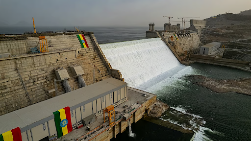
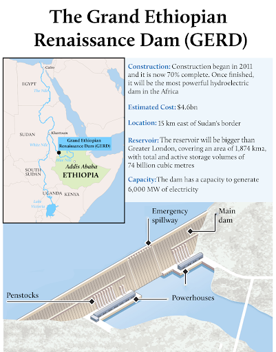
A recent study by Chapman University (California) identified the saddle dam of the Grand Ethiopian Renaissance Dam (GERD) as an active geohazard hotspot, posing threat to downstream nations like Sudan and Egypt.
What is the Grand Ethiopian Renaissance Dam (GERD) Project?
The GERD is a massive hydroelectric dam project, initiated in 2011, to generate approximately 6,000 megawatts of electricity.
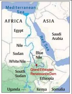
Location: Dam built on the Blue Nile River in Ethiopia, which is the primary tributary of the Nile, in Benishangul-Gumuz Region, near the Sudanese border.
Key Features: The project includes a main dam and a large auxiliary dam, known as the saddle dam.
Controversy: Egypt considers it an existential threat to its water supply, while Sudan expects both benefits (regulated flow) and risks (dependent management).
Why is the GERD a Source of Regional Conflict?
The GERD is a major source of regional tension due to conflicting national interests over the Nile's water resources.
|
Country |
Position and Rationale |
|
Egypt |
|
|
Sudan |
|
|
Ethiopia |
|
Source: DOWNTOEARTH
|
PRACTICE QUESTION Q. Consider the following statements regarding the Nile River: 1. The Blue Nile, which originates at Lake Victoria, provides the majority of the water volume to the main Nile. 2. The White Nile and the Blue Nile meet at Khartoum, Sudan, before flowing north toward the Mediterranean Sea. Which of the statements given above is/are correct? (A) 1 only (B) 2 only (C) Both 1 and 2 (D) Neither 1 nor 2 Answer: B Explanation: Statement 1 is incorrect: While the Blue Nile does provide the majority of the water volume to the main Nile (contributing about 80-85% of its flow), it originates at Lake Tana in the Ethiopian highlands, not Lake Victoria. Lake Victoria is the primary source of the White Nile. Statement 2 is correct: The White Nile (flowing north from Lake Victoria) and the Blue Nile (flowing from Ethiopia) meet at a confluence in Khartoum, Sudan. From this point, the combined river flows northward through Egypt to the Mediterranean Sea. |
The GERD is a massive hydroelectric dam built by Ethiopia on the Blue Nile River, close to the Sudan border. It is Africa's largest hydropower project, designed to generate about 6,000 MW of electricity and fuel Ethiopia's economic development.
The conflict over the Nile's water and the dam involves Egypt's fear of reduced water supply, Sudan's safety concerns and potential flood control benefits, and Ethiopia's assertion of its sovereign right for national development.
The Nile River is the longest river in the world, stretching approximately 6,650 kilometers through northeastern Africa. It serves as a vital, life-sustaining water source for 11 countries, flowing northward from its sources in Burundi and Rwanda to the Mediterranean Sea.


© 2026 iasgyan. All right reserved