Disclaimer: Copyright infringement not intended.
Context
- The Andaman and Nicobar Islands administration is making necessary arrangements as Cyclone Asani is likely to approach the shores.
The name
- The name Cyclone Asani was suggested by Sri Lanka.
- Cyclone Asani is the first cyclone of 2022 is set to hit Andaman and Nicobar.
Cyclone
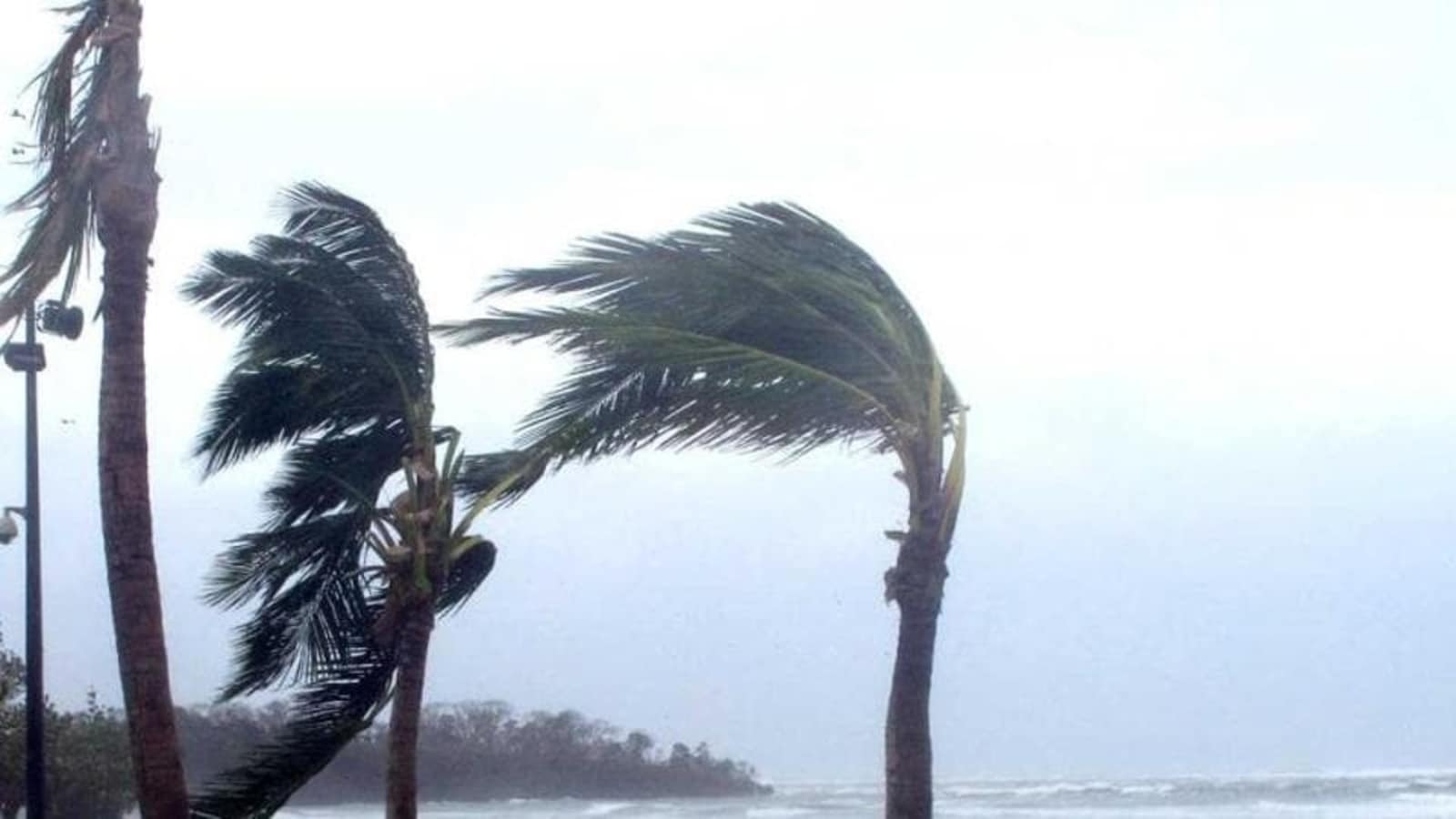
- A cyclone is a large scale air mass that rotates around a strong center of low atmospheric pressure. Cyclones are usually accompanied by violent storms and bad weather.
- The air circulates inward in an anticlockwise direction in the Northern hemisphere and clockwise in the Southern hemisphere.Cyclones are classified as:
- (i) extra tropical cyclones (also called temperate cyclones); and
- (ii) tropical cyclones.
What are Tropical Cyclones?
- Cyclones that develop in the regions between the Tropic of Capricorn and Tropic of Cancerare called tropical cyclones.
- Tropical cyclones are intense circular storms that originate over warm tropical oceans. They rotate in a counterclockwise direction in the Northern Hemisphere and in a clockwise direction in the Southern Hemisphere.
- They are characterized by low atmospheric pressure, high winds, and heavy rain.
- Drawing energy from the sea surfacea tropical cyclones maintains its strength as long as it remains over warm water.
- Note:Extra tropical cyclones occur in temperate zones and high latitude regions, though they are known to originate in the Polar Regions.
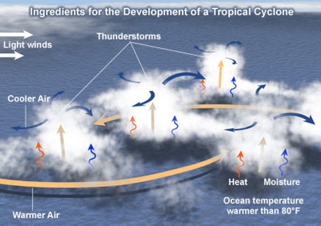
Conditions for development of Tropical Cyclones
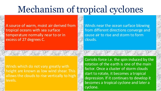
- There are six main requirements for tropical cyclogenesis:
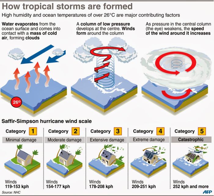
- sufficiently warm sea surface temperatures (higher than 26º C),
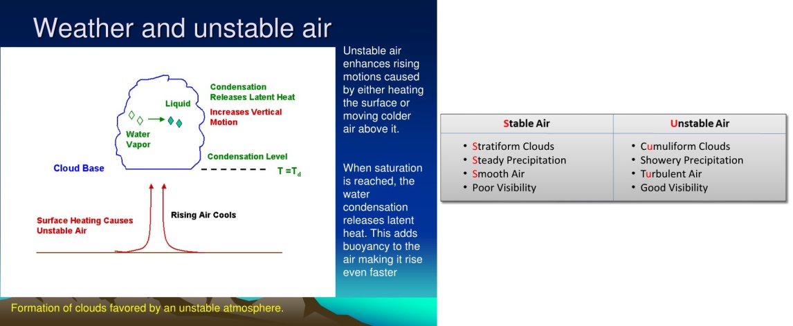
- atmospheric instability,
- high humidity in the lower to middle levels of the troposphere,
- enough Coriolis force to sustain a low pressure center,
- a pre-existing low level focus or disturbance, and
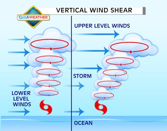
- low vertical wind shear
- Note:While these conditions are necessary for tropical cyclone formation, they do not guarantee that a tropical cyclone will form.
|
KEY CONCEPTS
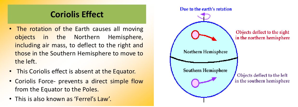
Coriolis effect
· The Coriolis effect is the apparent acceleration of a moving body as a result of the Earth's rotation. It makes things (like planes or currents of air) traveling long distances around the Earth appear to move at a curve as opposed to a straight line. The Coriolis effect is an important determinant of wind direction on a global scale.
Wind shear
· Wind shear sometimes referred to as wind gradient, occurs when there is a change in the direction or speed of wind usually at short distances. Atmospheric wind shear is normally described as either vertical or horizontal wind shear.
· Vertical wind shear is a change in wind speed or direction of winds at increasing heights in the atmosphere. Horizontal wind shear is a change in wind speed with change in lateral position for a given altitude.
Atmospheric Instability
· Atmospheric stability determines whether or not air will rise and cause storms; sink and cause clear skies; or essentially do nothing.
· If an air parcel is warmer than its surrounding environment, then it will be less dense than its surroundings and will rise like a hot air balloon. This is Unstable Air and has the potential for creating thunder storms if it contains enough water vapor.
· If an air parcel is cooler than its surrounding environment, then it will be denser than its environment and will sink. Think of this situation as a pebble sinking in water. This is Stable Air which generally leads to clear skies.
· If an air parcel is the same temperature as its surrounding environment, then the parcel will not move of its own accord. This is Neutral Air.
|
Depending on where a tropical storm is born, they are called by unique names:
- Hurricanes – born in the Atlantic ocean;
- Tropical Cyclones – born in South East Asian oceans
- Typhoons – born in the Pacific ocean,
- Willy Willies – born near Australia
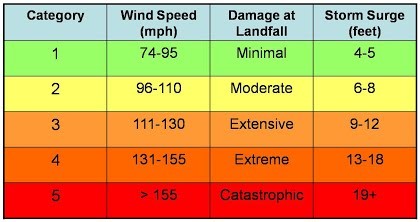
Cyclone Categories
Structure of a Tropical Cyclone
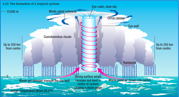
The eye
- The eye of the storm is the centre. It is the area of sinking air at the center of circulation. The eye is characterized by clear skies and calm weather. It is circular in shape and in size ranges from 8 - 200 km.
The eyewall
- The eyewall is the band around the eye with maximum wind speed, heaviest rainfall and greatest height. It is responsible for the maximum damage caused by a cyclone.
Rainbands
- These are Curved bands of clouds and thunderstorms that trail away from the eye wall in a spiral fashion. These bands are capable of producing heavy bursts of rain and wind. There are sometimes gaps in between spiral rain bands where no rain or wind is found.
How are the cyclones named?
- If the speed of a cyclone is more than 34 nautical miles per hour then it becomes necessary to give it a special name. In 2000, a group of nations called WMO/ESCAP (World Meteorological Organisation/United Nations Economic and Social Commission for Asia and the Pacific), decided to start naming cyclones in the region. The group comprised of Bangladesh, India, the Maldives, Myanmar, Oman, Pakistan, Sri Lanka and Thailand. The WMO/ESCAP expanded to include five more countries in 2018 — Iran, Qatar, Saudi Arabia, United Arab Emirates and Yemen.
- After each country sends in suggestions, the WMO/ESCAP Panel on Tropical Cyclones (PTC) finalizes the list. These lists are used sequentially and they are not rotated every few years.
Guidelines to adopt names of cyclones
- The proposed name should be neutral to
- politics and political figures
- religious believes,
- cultures and
- gender
- Name should not hurt the sentiments of any group of population over the globe.
- It should not be very rude and cruel in nature.
- It should be short, easy to pronounce and should not be offensive to any member.
- The maximum length of the name will be eight letters.
- The proposed name should be provided with its pronunciation and voice over.
- The names of tropical cyclones over the north Indian Ocean will not be repeated. Once used, it will cease to be used again. Thus, the name should be new.
Tropical Cyclones and India
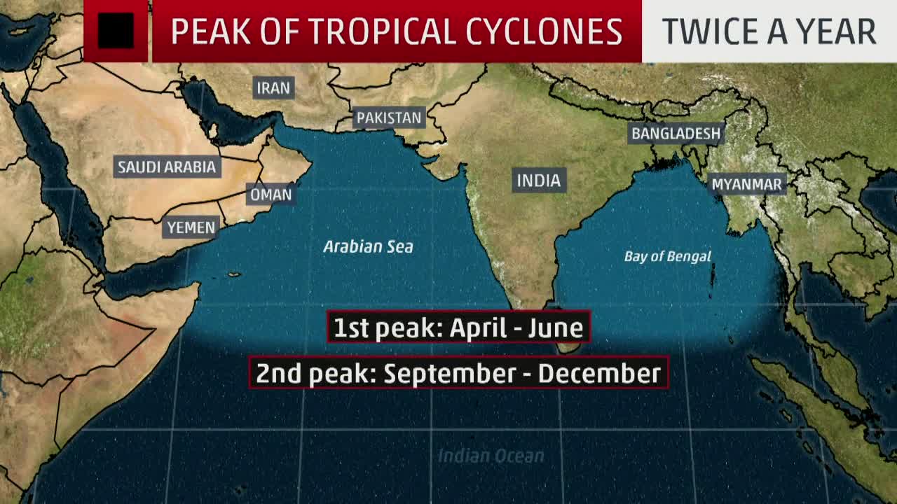
- India is the place in the North Indian Ocean that is most vulnerable to getting hit by tropical cyclones, from the east or from the west. On average, 5-6 tropical cyclones make landfall in India each year.
- The subcontinent with a long coastline of 8041 kilometres is exposed to nearly 10 per cent of the world’s tropical cyclones.
- Of these, majority of cyclones have their initial genesis over the Bay of Bengal and strike the East coast of India.
The usual trend: India’s east coast is a magnet for cyclones
- Though both are located in the same latitude band and receive the same amount of solar radiationfrom the Sun, the Bay of Bengal is much warmer than the Arabian Sea and many more storms brew over the bay.
- Oceanic circulation and heat removal:The winds over the Arabian Sea are stronger because of the presence of the mountains of East Africa. These strong winds force a much more vigorous oceanic circulation and the heat received at the surface is transported southward and into the deeper ocean.
The winds over the Bay of Bengal, in contrast, are more sluggish and the bay is unable to remove the heat received at the surface. Hot water temperature is the basic criteria for the development and intensification of cyclones. The average temperature in the Bay of Bengal around the year is high - about 28 degrees.
- Sea surface temperature: The bay receives more rainfall; it also receives more freshwater from the large rivers, especially the Ganga and the Brahmaputra, that empty into it.
This freshens the surface of the bay and stabilizes the water column, making it more difficult for the winds to mix the warm, stable surface layer with the cooler waters below.
In the Arabian Sea, there is no such stabilizing effect. As a consequence, the mixing with the cooler waters below is more vigorous. Since a sea surface temperature of about 28ºC is necessary for convection to take place in the atmosphere, this condition is satisfied in the Bay of Bengal but not in much of the Arabian Sea. Thus, in spite of their geographical similarities, the two arms of the north Indian Ocean are strikingly different when it comes to climate.
- Pacific Ocean:Pacific Ocean is a hot bed for cyclonic activities and hence typhoons originating in the Pacific ocean influences the cyclones in Bay of Bengal. This is not the case in Arabian Sea.
- Salinity:The Arabian Sea is saltier than the Bay of Bengal. As a result, it easily gets heated up and evaporates faster.
- Movement:According to IMD cyclones originating in Arabian Sea move northwest. So they actually move away from Indian mainland.
Why has Arabian Sea turned into a cyclone hotspot in the recent past?
- According to the India Meteorological Department, the frequency and intensity of cyclonic activity in the Arabian Sea was the highest it had been in over a century, in 2019.
- Five cyclones originated in the area in 2019 — Vayu, Hikka, Kyarr, Maha and Pavan.
- Scientists are in agreement that rising sea surface temperatures (SST) in the Arabian Seaare contributing to the formation of an increased number of cyclones.
- SST in the Arabian Sea rose by a staggering 0.36 degrees Celsius, compared with the baselines temperatures between 1981 and 2010.
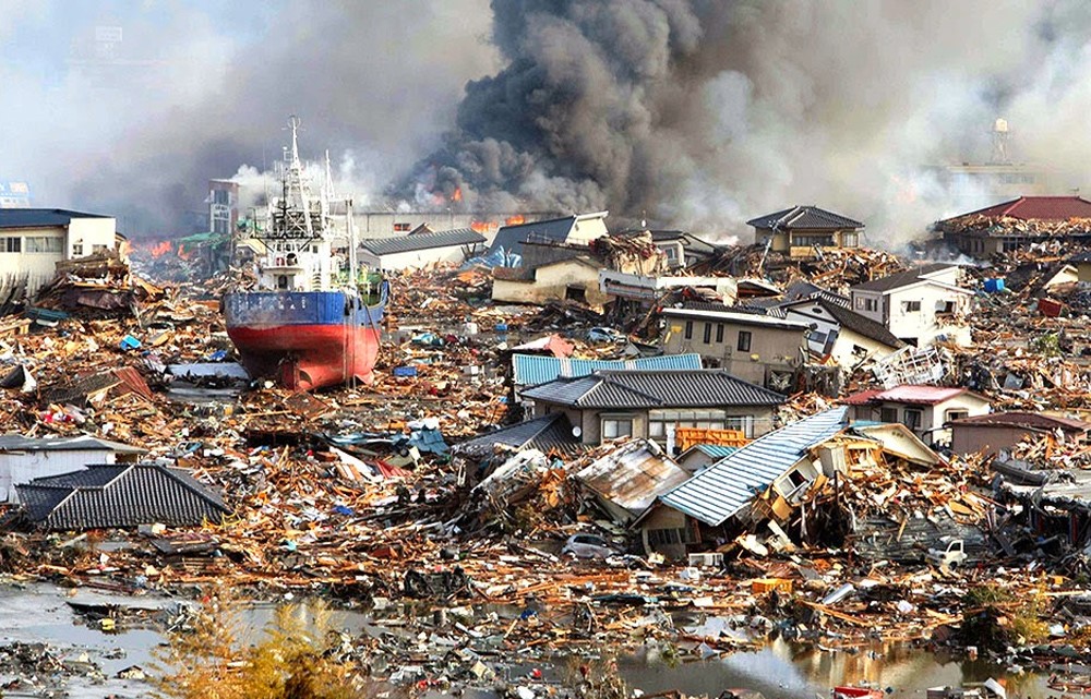
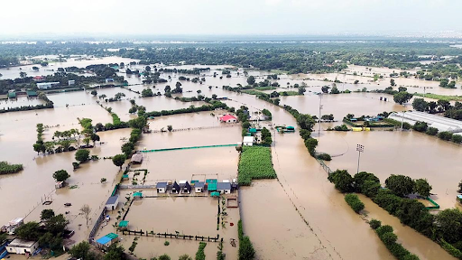
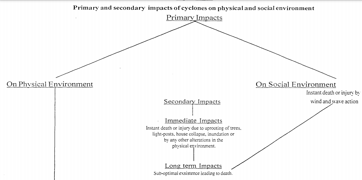
Impact of Cyclones
Issues in Cyclone mitigation
- Cyclone Amphan is the latest reminder that India needs to upgrade its disaster management systems. In 2019, India saw five million new internal displacements caused by climate disasters.
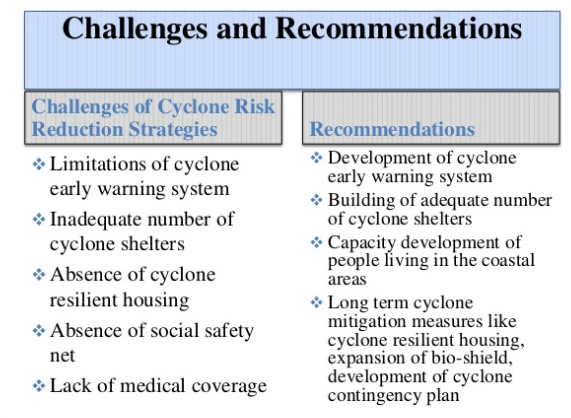
Other issues
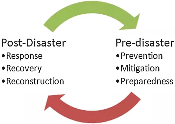
- Focus on Post disaster management rather than Pre- Disaster management There should be a fine balance between the two.
- Lack of coordination:There is a lack of coordination between the agencies of state government, central government with the local communities.
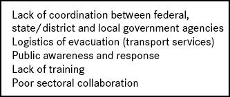
- Communication issues:Information and Cyclone warnings are not properly disseminated between the concerned agencies. This results in delayed efforts as was evident in Ockhi cyclone disaster.
Case study
Learning from Odisha’s Disaster Mitigation Preparedness
- Recently, Cyclone Fani wreaked havoc on Odisha.
- The Odisha government showed a high degree of preparedness and effectively managed to evacuate about 1.2 million people based on IMD’s prior predictions.
- The government successfully managed to minimize the loss of life.
- Odisha has a great community outreach system through which people are being reached on time.
- It now has a network of 900 cyclone sheltersand there is a robust mechanism for the maintenance of the cyclone shelters.
- Each cyclone shelter has a maintenance committee where youth have been involved and trained for search and rescue, first aid medical attention, and for providing cyclone warnings.
- Through a network of these shelters and committees and training, the state has involved the entire community.
- It is now fairly easy to disseminate warnings and move people into safe cyclone shelters.
- The state’s disaster management systems are monitored twice each year, given the propensity of natural disasters in the state.
- Cyclone Fani was not the first time that a poor state like Odisha has managed to successfully evacuate millions of people during a natural disaster; it also did so during Cyclone Phailin in 2013.
- Odisha has managed to create a sense of community during such disasters that other states can also emulate.
Way ahead
https://www.indiatoday.in/india/story/andaman-and-nicobar-islands-brace-for-cyclone-asani-all-you-need-to-know-1927140-2022-03-20