The Zojila Pass avalanche highlights flaws in Himalayan disaster preparedness, necessitating the Swiss Alpine model and NDMA guidelines. Securing this strategic corridor requires sensor-driven traffic management and the urgent completion of the Zojila Tunnel.
Why In News?
A devastating avalanche struck the high-altitude Zojila Pass on the Srinagar–Leh National Highway (NH-1), claiming seven lives and injuring five others.
What is Zojila Pass?
Zojila Pass is a high-altitude mountain pass in the Himalayas that connects the Kashmir Valley to the Union Territory of Ladakh.
Key Geographical Facts
Location: Situated in the Drass subdivision of the Kargil district (Ladakh). It lies on National Highway-1 (NH-1).
Elevation: Approximately 11,575 feet
Mountain Range: It is located in the Greater Himalayan Range.
Connectivity: It connects Srinagar (via Sonamarg) in the west to Leh (via Drass and Kargil) in the east.
Ranking: It is the second-highest pass on the Srinagar-Leh highway (the highest is Fotu La).
Strategic Importance
Military Lifeline: It is the only ground route for the Indian Army to transport tanks, artillery, and rations to troops stationed in Ladakh, Siachen Glacier, and along the Line of Actual Control (LAC) facing China.
Operation Bison (1948): Zojila was the site of battle during the 1947-48 Indo-Pak War.
The "Winter Blockade" Challenge
Due to heavy snowfall (up to 50-60 feet) and avalanches, the pass traditionally remains closed for 5 to 6 months (November to April), cutting Ladakh off from the rest of India.
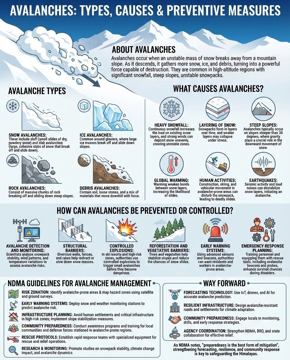
What are Avalanches?
An avalanche is a rapid downslope movement of a mass of snow, ice, and debris. It occurs when the gravitational force exceeds the mechanical strength of the snowpack.
Classification of Avalanches
Slab Avalanche: A block of snow slides over a weaker "bed surface." These are the most dangerous and account for 90% of fatalities. (Source: DGRE)
Loose Snow Avalanche (Sluff): Starts at a point and fans out; common in fresh, powdery snow on steep slopes.
Wet Snow Avalanche: Triggered by rapid solar warming or rain-on-snow events. Water lubricates the layers, causing the heavy mass to slide.
Powder Snow Avalanche: A mix of snow and air moving at speeds up to 300 km/h, creating a destructive air-blast wave. (Source: NDMA)
Trigger Factors
Terrain: Most occur on slopes between 30° and 45°. Slopes steeper than 50° shed snow constantly, preventing massive build-up.
Snowpack: Layers of different densities. A "weak layer" (like hoar frost) acting as a sliding base is a prerequisite for slab avalanches.
Weather/Trigger: Heavy snowfall (loading), wind (creating overhanging "cornices"), or sudden temperature rise.
What are the Impacts of Avalanche?
Military Vulnerability:: The Army loses more soldiers to "weather and terrain" (avalanches/high-altitude pulmonary edema) in the Siachen Glacier and Kargil sectors than to enemy fire.
Sogistical chokepoints: Strategic highways like NH-1 (Srinagar-Leh) and the Manali-Leh road pass through high-risk zones like Zojila and Rohtang. Blockages force an expensive "Air Bridge" (C-17 Globemaster sorties) to maintain troop supplies.
Infrastructure Stress: Border infrastructure projects, including the Zojila Tunnel and Shinku La Tunnel, must incorporate "Avalanche Protection Galleries" to prevent portals from being buried.
Way Forward to Manage Avalanche
Avalanche Control Structures: Construct Snow Sheds (concrete tunnels over the road) at identified "Red Zones."
Active Mitigation: Adopt the Swiss model of "Artificial Triggering," where small explosives are used to trigger controlled avalanches during off-hours to prevent massive build-ups.
Expedite Construction: The Zojila Tunnel must be treated as a "National Security Project" with monitored milestones to ensure the deadline is not missed.
Unified Command Centre: Establish a trans-boundary "Zojila Safety Authority" comprising Army, BRO, and Civil Administration from both J&K and Ladakh to eliminate jurisdictional delays during disasters.
Conclusion
Managing avalanches requires a blend of Geological Intelligence and Administrative Vigilance. As India pushes for "Vibrant Villages" and border infrastructure, ecological sensitivity must be the cornerstone of engineering.
Source: THEHINDU
|
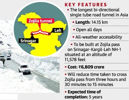
PRACTICE QUESTION Q. With reference to the Zojila Pass, consider the following statements: 1. It connects the Kashmir Valley with the UT of Ladakh. 2. Operation Bison was a military feat to recapture this pass in 1948. 3. The Zojila Tunnel, once completed, will be the longest bi-directional tunnel in Asia. Which of the statements given above are correct? A) 1 and 2 only B) 2 and 3 only C) 1 and 3 only D) 1, 2 and 3 Answer: D Explanation: Statement 1 is correct: Zojila Pass is a high mountain pass located on National Highway 1 (NH-1) that connects Srinagar (in the Kashmir Valley) with Leh (in the Union Territory of Ladakh). Statement 2 is correct: Operation Bison was the code name for the surprise offensive launched by the Indian Army on November 1, 1948, to recapture Zojila Pass from Pakistani raiders. Statement 3 is correct: The Zojila Tunnel, currently under construction, is projected to be Asia's longest bi-directional tunnel upon completion. |
Situated at an elevation of 11,575 feet on NH-1, Zojila Pass is the sole surface link connecting Ladakh with Jammu & Kashmir and the rest of India. It is highly critical for transporting civilian supplies and medical goods, and serves as the primary artery for deploying military troops, heavy weaponry, and logistics to the LAC and LoC.
A wet-snow avalanche occurs when a rapid rise in daytime temperatures and bright sunlight (solar radiation) melt and weaken the structural integrity of a snowpack. The heavy, wet snow eventually collapses and slides rapidly down steep slopes, usually occurring during afternoon hours.
Constructed by the National Highways and Infrastructure Development Corporation Limited (NHIDCL), the Zojila Tunnel is a 14.15-km long bi-directional high-altitude tunnel. Once completed (expected between 2027-2028), it will be Asia's longest of its kind, bypassing the perilous Zojila Pass and reducing crossing time from 3 hours to just 15 minutes.


© 2026 iasgyan. All right reserved