IAS Gyan

Daily News Analysis

STRAIT OF GIBRALTAR

26th December, 2023 Geography

STRAIT OF GIBRALTAR

Disclaimer: Copyright infringement not intended.

Context

  • Iran has threatened to close the Strait of Gibraltar and the Mediterranean Sea unless Israel stops bombing Gaza, as the US warned Tehran was “deeply involved” in attacks on shipping.

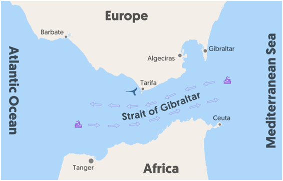
About Strait of Gibraltar

  • It is a slender canal that links the Mediterranean Sea to the Atlantic Ocean and divides Europe from Africa.
  • The Strait of Gibraltar was the only route to the Mediterranean Sea until the Suez Canal opened in 1869.
  • Its borders are to the north with Spain and the British Overseas Territory of Gibraltar, and to the south with Morocco, an African nation, and the Spanish exclave of Ceuta.
  • At its narrowest point, its length is around 58 km, while its breadth is approximately 13 km.
  • It is a substantial chasm that separates the Atlas Mountains of Northern Africa from the high plateau of Spain, with a depth ranging from 300 to 900 metres.
  • According to geological research, the African Plate moving northward towards the European Plate is what created the strait.
  • It is among the world's busiest waterways.
  • Every day, roughly 300 ships one every five minutes cross the Strait.
  • The Moroccan port of Tanger-Med, close to Tangier, is a significant port situated on the strait.
  • Pillars of Heracles: The easternmost point of the strait, which is roughly 23 km wide, is situated between Mount Hacho, also known as Jebel Moussa, in the south, and the Rock of Gibraltar in the north.
  • The Pillars of Heracles are these two geographical landmarks on the eastern end of the strait.

PRACTICE QUESTION

Examine the geopolitical significance of the Strait of Gibraltar in the context of international trade, maritime security, and regional stability.