Description
Disclaimer: Copyright infringement not intended.
Context
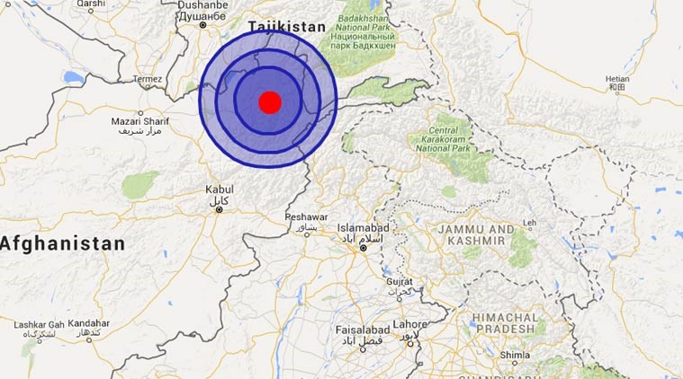
- Throughout its history, Afghanistan has witnessed numerous violent earthquakes, particularly in the mountainous Hindu Kush region, which shares a border with Pakistan.
- According to the World Health Organization (WHO), women and children make up the vast majority of earthquake victims in Afghanistan.
Details
Earthquakes in Afghanistan
- Afghanistan, hemmed in by mountains, has a long history of strong earthquakes, many in the rugged Hindu Kush region bordering Pakistan.
What Causes Earthquakes in Afghanistan?
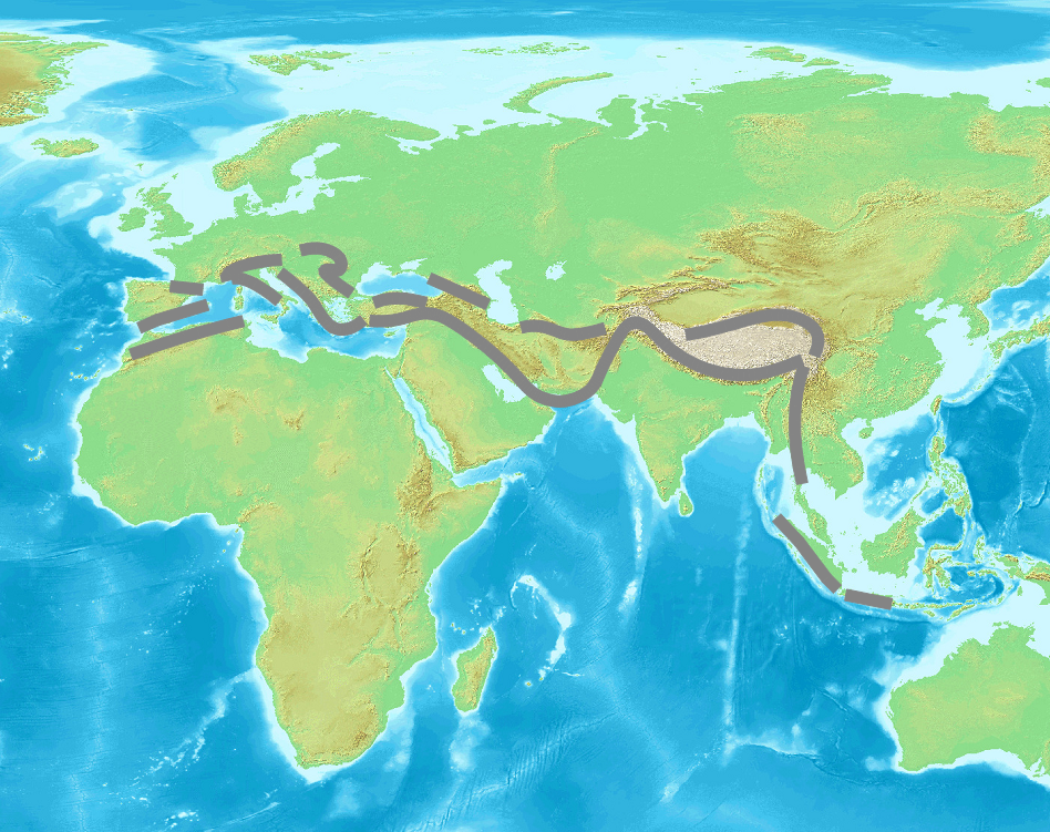
Location in Alpide Belt (or Alpine-Himalayan Orogenic Belt)
- Afghanistan is prone to earthquakes due to its location in the Hindu Kush region, which is part of the Alpide belt.
- After the circum-Pacific belt, the Alpide belt is the world's second most seismically active zone.
- It is a new mountain range that stretches from the Atlantic to the Himalayas.
- When the African, Arabian, and Indian Plates collided with the Eurasian Plate, the Tethys Ocean closed, forming the Alpide belt.
- Seismic activity is caused by plate collisions at the convergent plate boundary.
Faultlines
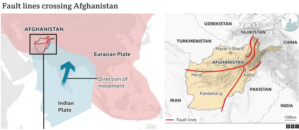
- A faultline is a line on the ground or on a rock surface that traces a geological fault.
- A fault is a crack in the Earth's crust caused by the movement of two blocks of rock relative to each other.
- When rock blocks move quickly, energy is released, resulting in earthquakes.
- Plate collision is one of the factors that causes a fault.
- Afghanistan is situated on top of several fault lines where the Indian and Eurasian plates collide.
What is an Earthquake?
- In simple terms, an earthquake is the shaking of the earth.
- It is a natural occurrence. It is created by the discharge of energy, which causes waves to propagate in all directions.
- Seismic waves are vibrations caused by earthquakes as they move through the Earth and are recorded on seismographs.
- The hypocenter is the point beneath the earth's surface where the earthquake begins, while the epicenter is the location directly above it on the earth's surface.
- Earthquake types include fault zones, tectonic earthquakes, volcanic earthquakes, and earthquakes caused by humans.
- The earthquake events are scaled either according to the magnitude or intensity of the shock. The magnitude scale is known as the Richter scale.
- The magnitude relates to the energy released during the quake. The magnitude is expressed in absolute numbers, 0-10.
- The intensity scale is named after Mercalli, an Italian seismologist.
- The intensity scale takes into account the visible damage caused by the event. The range of intensity scale is from 1-12.
Distribution of Earthquake
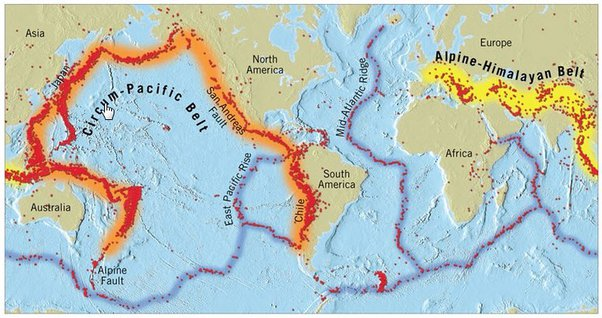
Circum-Pacific Seismic Belt:
- The world's largest earthquake belt, the circum-Pacific seismic belt, is found along the Pacific Ocean's rim, where approximately 81% of our planet's major earthquakes occur.
- It is known as the "Ring of Fire".
- The belt exists along tectonic plate boundaries, where plates of predominantly oceanic crust descend (or subduct) beneath another plate.
- Slip between plates and plate rupture produce earthquakes in these subduction zones.
Mid Continental Belt:
- The Alpine-Himalayan belt (mid-continental belt) stretches from Europe to Sumatra, passing via the Himalayas, the Mediterranean, and out into the Atlantic.
- This belt is responsible for around 17% of the world's greatest earthquakes, including some of the most devastating.
Mid-Atlantic Ridge:
- The third prominent belt follows the submerged mid-Atlantic Ridge. The ridge marks where two tectonic plates are spreading apart (a divergent plate boundary).
- Most of the mid-Atlantic Ridge is deep underwater and far from human development.
Seismic Hazard Map of India
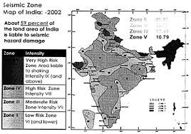
- Because of the existence of technically active young fold mountains such as the Himalayas, India is one of the most earthquake-prone countries.
- Based on scientific inputs relating to seismicity, prior earthquakes, and the region's geological configuration, India has been categorized into four seismic zones (II, III, IV, and V).
- Previously, earthquake zones were split into five severity zones, however, the Bureau of Indian Standards (BIS) organized the country into four seismic zones by combining the first two zones.
Seismic Zone II:
- Area with minor damage earthquakes corresponding to intensities V to VI of MM scale (MM-Modified Mercalli Intensity scale).
Seismic Zone III:
- Moderate damage corresponding to intensity VII of MM scale.
Seismic Zone IV:
- Major damage corresponds to intensity VII and higher on the MM scale.

Seismic Zone V:
- The area is determined by the seismic of certain major fault systems and is seismically the most active region.
- Earthquake zone V is the most vulnerable to earthquakes, where historically some of the country’s most powerful shocks have occurred.
- Earthquakes with magnitudes over 7.0 have occurred in these areas, and have had intensities higher than IX.
|
PRACTICE QUESTION
Discuss the numerous forms of plate tectonic borders found around the planet using plate tectonic theory. (250 Words)
|


