Description
Disclaimer: Copyright infringement not intended.
Context:
After Philippines, China ‘Schemes’ To Encroach Vietnam’s Territory In Gulf Of Tonkin.
Details:
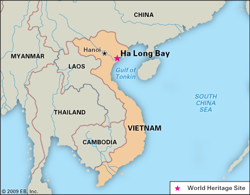
Gulf of Tonkin
- Gulf of Tonkin, northwest arm of the South China Sea, bounded by China (north and east), Hainan Island (east), and northern Vietnam (west).
- The gulf is 300 miles (500 km) long, 150 miles (250 km) wide, and up to 230 feet (70 metres) deep.
- The main shipping route is via the Hainan Strait, between China and Hainan Island.
- The gulf receives the Red River, and its main ports include Ben Thuy and Haiphong in northern Vietnam and Beihai (Pakhoi) in China.
Historical Event
- The report of North Vietnamese torpedo boats firing on two U.S. destroyers in 1964 resulted in the U.S. Congress adopting the Gulf of Tonkin Resolution to support increased U.S. troop involvement in the Vietnam War.
- In 1972 the gulf was the scene of increased naval activity when the U.S. Navy mined the entrances to North Vietnamese ports.
- Since the end of the Vietnam War, the Gulf of Tonkin has been the site of oil exploration by many multinational companies.
- It has been a historically significant point of maritime demarcation between China and Vietnam in the northwestern South China Sea.

Recent Development
- China has officially disclosed a new baseline outlining its territorial claims in the northern part of the Gulf of Tonkin, an area shared with Vietnam.
- The announcement introduces seven base points that, when connected, form the baseline for Beijing’s sovereignty claims in the Gulf of Tonkin, known as Beibu Gulf in China.
- According China , the announcement of the territorial sea baseline was an essential step in exercising national sovereignty and jurisdiction.
- The statement also noted the existence of different management regulations and usage plans for internal waters, territorial seas, and exclusive economic zones, which emphasize the need for clearly defined baselines to facilitate the standardized and scientific use of the sea by coastal provinces and regions.
- Further, the China contends that the delineation of the baseline for the northern part of the Beibu Gulf was integral to China’s broader efforts to improve territorial sea baseline delineation. This move according to China aimed to support the economic development of provinces and regions along the northern part of the Beibu Gulf, including Guangxi, Guangdong, and Hainan.
What Is Territorial Sea Baseline?
- The territorial sea baseline serves as the foundation marker for coastal nations to establish their maritime jurisdiction claims and also signifies the outermost boundary of their national land territory.
- According to the United Nations Convention on the Law of the Sea (UNCLOS), coastal states are entitled to a territorial sea width of 12 nautical miles (22.22 km), a 200-nautical mile exclusive economic zone (EEZ), and a continental shelf extending up to 350 nautical miles.
Issue with Beibu Gulf
- The Beibu Gulf, a semi-enclosed bay surrounded by mainland China, Vietnam, and China’s Hainan Island, has a maximum width of no more than 180 nautical miles.
- This circumstance leads to a complete overlap of the exclusive economic zones and continental shelves of both countries within the Gulf, as outlined by the convention. Consequently, the entire Gulf is subject to overlapping claims by China and Vietnam.

Concerns Regarding The New Baseline
- Vietnam and China inked a clear demarcation line agreement for the Gulf of Tonkin back in 2000, which should buffer any substantial blow to Vietnam’s economic interests from the fresh baseline, provided China doesn’t push for renegotiation.
- However, experts have flagged concerns about the distance of some base points from the coast, raising doubts about the new baseline’s compliance with UN maritime law and its potential to complicate various maritime activities.
- Gulf of Tonkin/Beibu Gulf witnessed multiple boundary agreements between China and Vietnam in three decades from 1974 to 2004 devoting more than half of the waters to Vietnam. Declaring a new baseline seems excessive on the map which will further impact the EEZ and contagious zone of Vietnam providing major fishing zones to China.
- China’s new unilateral demarcation of the baseline is an attempt to limit Vietnam’s claims over their exclusive zones & to trim the high waters. China will get more access to the marine boundaries to tackle Western influence and assertiveness in tackling Southern part of the Gulf of Tonkin.
- The new baseline will provide more than 60% water to Chinese authorities, a gross violation of UNCLOS in the territorial sea. May Vietnam will not escalate this issue at the highest levels but not doing so will impact its fishing rights, supply chains, and sea lanes in the coming days.
- As China will not limit its misadventures in the South China Sea due to its ancient notion of controlling all the waters, the Gulf of Tonkin is one of the pins punched as per their self-centered verdicts.
- Additionally, the new baseline could hamper freedom of navigation, scientific research, cable and pipeline laying, and island reclamation efforts. Despite this, Hanoi has remained mum on China’s move.
- If Vietnam, on the lines of the Philippines, took the matter for arbitration, China would again reject the verdict, saying it illegal, null, and void. The matter of the fact is that the median line between China and Vietnam is being demarcated earlier, the second step of China will be to nullify it. It will give them more area of contention with Vietnam claiming exclusive economic zones in the Gulf of Tonkin.
|
PRACTICE QUESTION
Regarding the United Nations Convention on the Law of Sea, consider the following statements
- A coastal state has the right to establish the breadth of its territorial sea up to a limit not exceeding 12 nautical miles, measured from a baseline determined following the convention.
- Ships of all states, whether coastal or land-locked, enjoy the right of innocent passage through the territorial sea.
- The Exclusive Economic Zone shall not extend beyond 200 nautical miles from the baseline from which the breadth of the territorial sea is measured.
Which of the statements given above are correct?
- 1 and 2 only
- 2 and 3 only
- 1 and 3 only
- 1, 2 and 3
Answer 4
|


