Description
Disclaimer: Copyright infringement not intended.
Context
The high-level committee for Yamuna’s rejuvenation has set a target for the floodplain’s demarcation.
Details
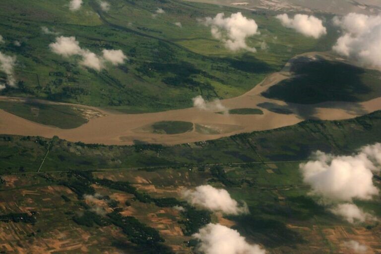
Floodplain
- A floodplain(or floodplain) is a generally flat area of land next to a river or stream. It stretches from the banks of the river to the outer edges of the valley.
Floodway
- A floodplain consists of two parts. The first is the main channelof the river itself, called the floodway. Floodways can sometimes be seasonal, meaning the channel is dry for part of the year.
Flood fringe
- Beyond the floodway is the flood fringe. The flood fringe extends from the outer banks of the floodway to the bluff linesof a river valley. Bluff lines, also called valley walls, mark the area where the valley floor begins to rise into bluffs.
- Some floodplains are extraordinarily wide and some rivers have very narrow floodplains.

Geology of a Floodplain
- The floodplains in India are of two types: a) peninsular (found in the Deccan plateau) where there are rock terraces (step-like structures created by lava flows), and those found in the Himalayan region, which are old, wide and depositional (created by the deposition of sediment).
- There are two major processes involved in the natural developmentof floodplains: erosion and aggradation.
Erosion
- The erosion of a floodplain describes the process in which earth is worn away by the movement of a floodway.
Aggradation
- Aggradation (or alluviation) of a floodplain describes the process in which earthen material increases as the floodway deposits sediment.
- A river erodes a floodplain as it meanders, or curves from side to side. The massive lowland floodplain of the River, for instance, is carved with hundreds of oxbow lakesthat document the meandering river and its tributaries over time.
Oxbow lakes
- Oxbow lakes are formed when a meander, or bend, in the river is cut off from the river’s mainstem. Features such as oxbow lakes and seasonal wetlands are often a part of floodplains created through erosion and deposition.
- A meandering stream can contribute to a floodplain’s aggradation, or build-up in land elevation, as well as its erosion. A typical aggradation environment is a wide, shallow, braided river.
- Braided rivers often include river deltas, where the main floodway is separated into discretechannels and tiny islands. The process of subsidence, in which the elevation of a delta may sink due to sea-level rise or human activity, often offsets aggradation in the floodplains in these areas.
Deposit of alluvium
- The alluvium, or sediment, of a floodplain varies. Its coarseness and composition depend on the surrounding landscapeand the velocity of the currents that created the floodplain. Some floodplains are mostly fine-grained silt, while others are sandy.
Crevasse splay
- The deposit of alluvium created as a river or stream breaks, or breaches, its bank is called a crevasse splay. The formation of a crevasse splay is very similar to the formation of an alluvial fan. The thickest layer of sediment is nearest the breach, while the thinnest and youngest sediments are fanned out.
Bank filtration
- The layered sediments of many floodplains can create important aquifers. Clay, sand, and gravel filterwater as it seeps Water purification systems often take advantage of this natural phenomenon in a process called bank filtration. In bank filtration, water is deliberately filtered through the banks or floodplain of a river or lake. Nearby wells then collect the filtered water, which is then ready for more intense purification processes.
Fluvial Terraces
- The sedimentary patterns of floodplains often provide scientists with evidence of past geologic Thick layers of sand may indicate flash flooding, for instance, while thin, evenly spaced layers of silt may indicate more moderate and predictableflood patterns.
- One of the most important geologic features of a floodplain is its fluvial terraces.
- Fluvial terraces are step-shaped areas of land that flankthe banks of a river or stream.
- Fluvial terraces mark the older, higher-elevation paths of the stream, before erosion and aggradation created the current mainstem of the stream or river.
- Fluvial terraces can mark the bluff lines—outer edges—of a floodplain.
- There are two major types of fluvial terraces: fill terracesand cut terraces. Fill terraces are formed as a valley or gorge is filled with alluvium. Alluvium can aggregate as a river meanders and overflows its banks, or it can be deposited by a glacier.
- While fill terraces are associated with aggradation, cut terraces are associated with erosion. Cut terraces are often formed below fill terraces, as water erodes sediment.
- Older floodplains and river valleys can have many fluvial terraces.
Significance of Floodplains
- Floods are usually seasonal and can be predicted months ahead of time. This predictability can make floodplains ideal locations to develop urban areas.
- Rivers provide both a natural transportationnetwork and source of water for irrigation and industry. The relatively level land can be developed either as agricultural fields or sites for habitation or business.
- A healthy floodplain gives rivers the space to spread out and slow down, which allows such sediment to settle. It keeps water cleaner, protecting local drinking water and aquatic species like fish.
- Shading of streams by floodplain vegetation also helps regulate water temperature.
- They are rich and biologically diverse environments that can support an abundance of plants, birds, fish, and other species on land and in the water. For example, Chinook salmon rely on floodplains for survival during the freshwater phase of their life cycle.
- Flood storage-Floodplains take on and store excess water in times of flood, releasing it slowly over land and into groundwater.
- Groundwater recharge-Rainwater travels deep into the ground of a floodplain to replenish groundwater supply.
- Groundwater travels slowly into rivers, lakes, and wetlands, regulating the availability of water during drier periods when people, plants, and animals need it most.
- They have rich, fertile soils that have made them attractive to farmers for generations.
- Sustainable agricultural practices can help support key floodplain functions.
- Floodplains provide numerous recreational opportunities via lakes, rivers, etc.,
- The long history of settlement in floodplains as people have been drawn to the fertile land and abundant resources create a shared culture and sense of place in these locations. Example- Indus valley civilization situated near the river Indus.
Agriculture
- Floodplains are usually very fertile agricultural areas. Floods carry nutrient-rich silt and sediment, and distributeit across a wide area. floodplains are flat and often have relatively few boulders or other large obstacles that may prevent farming.
- The rich floodplains of the Pampas, for example, are nicknamed the “Breadbasket of Argentina.” These lowlands are susceptibleto floods, but are also home to some of South America’s most lucrative grain farms and cattle ranches.
Transportation
- A floodplain’s flat terrainand slow-flowing rivers can provide excellent transportation corridors. Roads, bridges, railways, and even airports can be constructed on the even surface. Ships and barges can often haul cargo faster and more efficiently than roadways.
- The floodplains of the mighty Mississippi-Missouri river system in the central United States, for example, have served as vitaltransportation corridors for centuries.

Zoning of Flood Plains in India and Significance
- Zoning of floodplains refers to the practice of designating different areas within a floodplain for specific land uses and activities based on their vulnerability to flooding and associated risks.
- The Central Water Commission prepared floodplain zoning guidelines and the Model Bill for Floodplain Zoning was circulated by the Government of India in 1975.
- Acts provide for the establishment of a “Flood Zoning Authority”, to conduct surveys to determine the nature or extent of floodplains, prohibit or restrict the use of land in the floodplains, and impose penalties for non-compliance.
- Risk Reduction: By restricting certain types of development or activities in high-risk flood zones, floodplain zoning aims to reduce the vulnerability of communities to flood hazards.
- Environmental Protection: Floodplain zoning may also include provisions for preserving natural floodplains, wetlands, and other ecological features that provide important flood mitigation benefits and support biodiversity.
- Infrastructure Planning: Zoning regulations help in guiding the location and design of infrastructure such as roads, bridges, and utilities to minimize the impact of floods on essential services and transportation networks.
- Community Resilience: By promoting resilient land use practices and building standards, floodplain zoning contributes to the overall resilience of communities to flood events, reducing the social and economic disruptions caused by flooding.
Way ahead
However, despite the existence of floodplain zoning regulations, enforcement and compliance can be challenging due to various factors such as rapid urbanization, informal settlements, and inadequate resources for monitoring and enforcement. Additionally, the effectiveness of floodplain zoning depends on comprehensive flood risk assessment, public awareness, and stakeholder engagement in the planning process. Ongoing efforts are required to strengthen floodplain management practices in India to address evolving flood risks in the face of climate change and urban development pressures.
|
PRACTICE QUESTION
Discuss the role of floodplains in hydrological processes and their significance in flood risk management, considering both natural and anthropogenic factors."
|


