Description
Disclaimer: Copyright infringement not intended.
Context
- Scientists have developed a novel experimental which can help in developing early warning systems to minimize damage due to catastrophic events like landslides/earthquakes.
Earthquake
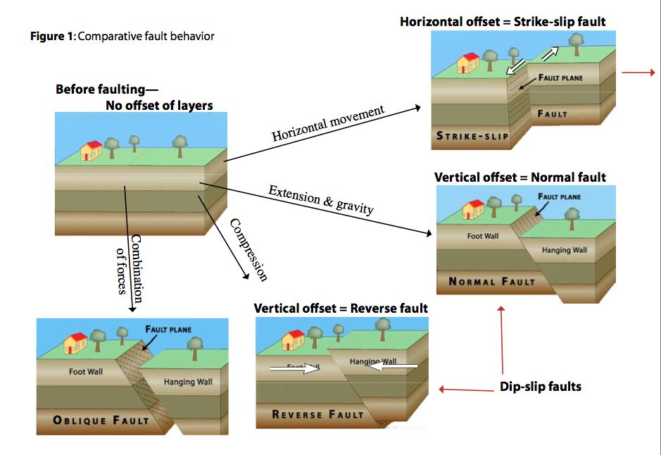
- An earthquake is the shaking of the Earth when two blocks of the earth suddenly slip past one another.
- The surface where they slip is called the fault or fault plane.
- The location below the earth’s surface where the earthquake starts is called the hypocenter, and the location directly above it on the surface of the earth is called the epicenter.
Types of Earthquakes
- Tectonic: A tectonic earthquake is one that occurs when the earth's crust breaks due to geological forces on rocks and adjoining plates that cause physical and chemical changes.
- Volcanic: A volcanic earthquake is any earthquake that results from tectonic forces which occur in conjunction with volcanic activity.
- Collapse: A collapse earthquake are small earthquakes in underground caverns and mines that are caused by seismic waves produced from the explosion of rock on the surface.
- Explosion: An explosion earthquake is an earthquake that is the result of the detonation of a nuclear and/or chemical device.
- Reservoir induced Earthquakes: These occur in the areas of huge reservoirs like dams.
Seismic Zones of India
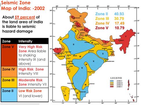
- Seismic zones in Indian subcontinent is divided into four seismic zones (II, III, IV, and V) based on
- scientific inputs relating to seismicity,
- earthquakes occurred in the past and
- tectonic setup of the region.
- The Bureau of Indian Standards is the official agency for publishing the seismic hazard maps and codes.
- It has brought out versions of seismic zoning map: a six zone map in 1962, a seven zone map in 1966, and a five zone map 1970/1984.
Seismic Active Zones
- Seismic Zone II
- Seismic Zone III
- Seismic Zone IV
- Seismic Zone V
|
Mercalli Scale: a twelve-point scale for expressing the local intensity of an earthquake, ranging from I (virtually imperceptible) to XII (total destruction).
Richter scale: It is a scale of numbers used to tell the power (or magnitude) of earthquakes.
|
Types of Seismic Waves
- BODY WAVES
- Traveling through the interior of the earth, body waves arrive before the surface waves emitted by an earthquake. These waves are of a higher frequency than surface waves.
- Body waves are of two types: Primary waves (also called P-waves, or pressure waves) and Secondary waves (S-waves, or shear waves).
|
P-Waves
|
S-Waves
|
|
Recorded first on the seismograph.
|
Recorded last on Seismic Waves
|
|
Longitudinal waves: Shake the medium in the direction in which they are propagating
|
Transverse waves: Shake the medium in the direction perpendicular to which they are moving
|
|
Compressional waves
|
Sheer waves
|
|
Least destructive
|
Slightly higher destructive power
|
|
Can travel in all mediums; Solid, Liquid and Gas
|
Can only move through solids
|
|
Velocity: 5 to 8 km/s.
|
60% the speed of P waves
|
|
Faster than the S-waves.
|
Slower
|
|
Shadow Zone: 103° and 142° away from the epicentre
|
Zone beyond 103° does not receive S-waves
|
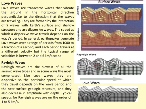
- SURFACE WAVES
- Travelling only through the crust, surface waves are of a lower frequency than body waves. Though they arrive after body waves, it is surface waves that are almost entirely responsible for the damage and destruction associated with earthquakes.
- The two types of surface waves are named Love waves and Rayleigh waves.
India and earthquakes
- More than 60% of the land in India is prone to moderate to very high-intensity earthquakes.
- Some major past earthquakes in India
1934 Bihar-Nepal Earthquake : 8.4 magnitude
1967 Koyna Earthquake : 6.5 magnitude
2001 Bhuj : 7.7 magnitude
2005 Jammu Kashmir Earthquake
Causes of Earthquakes in India
- North –East region: Collision zones of the Himalayan belt and Sumatran belt. Kopili fault is currently the most active seismic zone in North East India.
- Himalayan belt– Collision between Indo-Austral plate with Eurasian plate and Burma Plate with Java Sumatra.
- Andaman and Nicobar Islands– Seafloor displacement and underwater volcanoes.
- Deccan Plateau– Fault line and energy build-up along the fault line of the river Bhima (Krishna) near Latur and Osmanabad (Maharashtra).
- Anthropogenic: Increasing population and unscientific land use in construction.
Impact of Earthquakes
- Loss of Human Lives
- Change in River Course
- Landslide
- Floods
- Land Slide
- Tsunami
- Floods
- Avalanches
- Damage to property
Steps taken by Government to manage Earthquakes
- National Center for Seismology, Ministry of Earth Sciences: For Earthquake surveillance and Hazard Reporting
- National Earthquake Risk Mitigation Project
- National Building Code (NBC): To regulate building construction
- Building Materials & Technology Promotion Council (BMTPC): Areas of work-

- National Retrofitting Program
- ‘India Quake’ mobile app to disseminate real-time earthquake information.
International Cooperation
- 2019 Shanghai Cooperation Organization Joint Exercise on Urban Earthquake Search and Rescue- ‘SCOJtEx-2019’ held in New Delhi.
- BIMSTEC Disaster Management Exercise in Odisha.
- India is a signatory to the Sendai Framework for Disaster Risk Reduction.
- Coalition for Disaster Resilient Infrastructure (CDRI) launched by India at the 2019 UN Climate Action Summit.
Challenges and Gaps in Earthquake management in India
- Incomprehensive Polices: Scientific research findings on the Kopili fault earthquake zone have hardly made it into disaster reduction policies. Bridging this gap is key to formulating any meaningful earthquake damage mitigation plans.
- Hilly and mountainous region: Retrofitting is difficult and costly in these regions
- Lack of Skilled Human Resource: for resistant design and building.
- Poor/no campaign of sensitizing the decision-makers and Government on the need for earthquake preparedness.
- Lack of formal competency based licensing of structural engineers and masons.
- Even today most consulting engineers do not follow even the available Indian Standard design provisions for making earthquake-resistant constructions,
- Restricted earthquake engineering and preparedness education.
- Inadequate monitoring and enforcement of earthquake-resistant building codes;
- Faulty construction: NDMA said that close to 4,000 multi-storied buildings in Ahmedabad won’t survive a high magnitude earthquake due to a faulty design.
- Paucity of funds: Insufficiency in fund mobilization.
- Disaster response regime not swift: Testimony - Uttarakhand floods
- Lack of awareness: and training of the local population.
Way forward
- Strengthening of emergency response capability in earthquake-prone areas.
- Implementation of NDMA guidelines on earthquake in letter and spirit.
- Exclusive earthquake management department.
- Investing in prevention is important, but is not a substitute for preparedness;
- Promotion of traditional Khasi model of houses in the hilly region.
- Single point contact mechanism to address coordination challenges.
- Training and capacity building of Local population at war footing.
- Research and development institutes for Earthquakes.
- Learning from other countries: Over the last century, seismic engineering has evolved in countries like Japan, New Zealand and USA, and is reasonably well documented. The Indian professional community can learn from this vast experience available across the world.
- The Case of Japan:
- Japan has a long history of devastating natural disasters – from lightning strikes that have destroyed entire castles to the 2011 Tohoku earthquake and tsunami that wiped out entire towns.
- Yet, Japan remains a thriving country. Japan's effective and contextualized Disaster Management System is important for all countries to see how theory is put into practice.
https://pib.gov.in/PressReleasePage.aspx?PRID=1833834
1.png)


